Contact

Creating an orthophotomap to the territory of the Klyuchevsky settlement, Zabaykalsky Krai

01

About the project

Acquisition of Earth remote sensing data from the Pleiades satellite, as well as the creation of an orthophotomap on their basis to the territory of the vicinity of the settlement Klyuchevsky, Trans-Baikal Territory.

Industry Geology and mining
End date 10/30/2015
02

Project goal

Acquisition of Earth remote sensing data from the Pleiades satellite, as well as the creation of an orthophotomap on their basis to the territory of the vicinity of the settlement Klyuchevsky, Trans-Baikal Territory.

03

Completed works

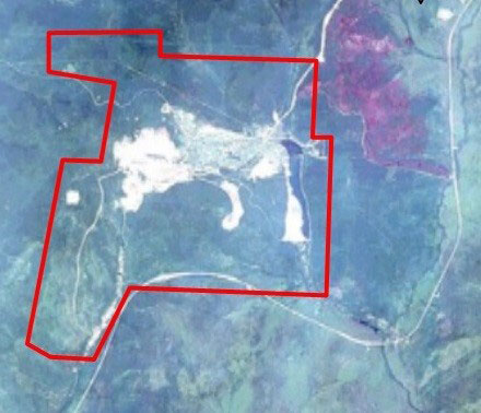
In the framework of the agreement, Innoter LLC carried out the selection and delivery of archival shooting from the Pleiades spacecraft, the Primery processing level, color version, spatial resolution of 0.5 m. The area of interest was 44 square meters. km

Basing on the image, orthorectification was performed using space-based RPC-coefficients and the SRTM-90 public digital elevation model.


The layout of the area. Area  44 sq. km.

04

Result

As a result of the order implementation, the necessary data were supplied from the Pleiades spacecraft, as well as work was performed on the creation of a digital orthophotomap.

Need satellite imagery or help choosing the right data?

Describe your task, area of interest, and desired outcome. We will check data availability, assess new acquisition options, and propose the optimal solution in terms of timelines, cost, and quality.
clients who trust us
25+ years in the geodata market
Request a call back
Back to page top
Мы используем Яндекс.Метрика и собственные Сookies для обеспечения наилучшего опыта работы на нашем сайте, персонализации сайта для наших пользователей и аналитики. Продолжая использовать сайт вы соглашаетесь с условиями Пользовательского соглашения.