of geospatial solutions
Sat-Sun: Non-working days
Customer
Mining and Metallurgical Combine LLC
Project's objective
Carrying out engineering and design and exploration work for the extraction of precious metals at the gold of the Kamchatka Territory.Completed work


Work description
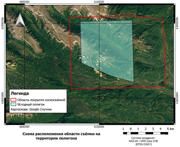
At the preparatory stage of the work, the selection and delivery of VNIR space stereo from WorldView-3 satellite in the license area of the customer's field was carried out. The nominal spatial resolution is 0.3 meters per pixel for the panchromatic channel and 1.24 meters per pixel for multispectral channels. Spatial data processing level: Ortho-Ready Stereo Standard (ready for orthorectification). The data format is GeoTIFF, the bit depth is 16 bits, the UTM projection, the ellipsoid, and the WGS-84 coordinate system.
At the next stage, the following types of work were carried out with the help of materials provided by the customer for the plan-and-height justification with a sufficient accuracy of coordinate measurements.
-
Creation of a Digital elevation model (DEM) based on panchromatic materials of space stereo filming. The creation of the DEM was carried out by the stereotopographic method. UPC (standard error) of the height of the DEM is not worse than 2 m.
-
In addition, the Digital Terrain Model (DTM) and the digital terrain model of the WorldDEM bundle DEM, resulting from interferometric data processing, were also created.
-
Creating digital Orthophotoplans of the terrain. Orthophotoplans were created basing on the DEM, the planning and high-altitude justification and satellite images of a given territory. UPC position of the orthophotomap contours is not worse than 2.5 m.
-
Creation of a digital specialized topographic plan of 1: 5000 scale in accordance with the technical specifications. Specialized topographic plans were created by the office interpretation of objects and included the following layers: vegetation, hydrography, road network, relief. The average errors (errors) in the position on the terrain contour plan with clear outlines relative to the closest points of the imaging justification did not exceed 0.5 mm, and in mountainous and forested areas - 0.7 mm on the scale of the created plan. UPC determination of heights on the issued topographic plans – no more than 2 m.
Need for consultation?
Fill the form and we will contact you
Sat-Sun: Non-working days