The main infrastructure project of the Republic of Congo, which will reduce the cost of transporting petroleum products.
Industry
Oil and gas
Customer
The RusGazEngineering Group of Companies, under a contract with the National Oil Company of the Congo, is implementing a project to build the oil pipeline Pointe-Noire – Brazzaville – Oyo – Ouesso with a branch Ye – Maluko – Trecheau. The project is being implemented under the patronage of the Russian-Congolese Intergovernmental Commission on Cooperation in the Field of Energy and the Ministry of Energy of the Russian Federation.
End date
12/26/2014
02
Project goal
The oil pipeline “Pointe-Noire – Brazzaville – Oyo – Ouesso” is the main infrastructure project of the Republic of Congo. The project was designed to reduce the cost of transportation of petroleum products, improve the safety of their transportation and, in general, ensure the sustainable development of remote areas of the Republic of Congo.
Innoter LLC, under the terms of the contract, fully provided the project with digital geospatial data — digital orthophotomaps of 1:10 000 terrain based on Earth remote sensing (RS), as well as a digital terrain model with a horizontal step of 5 m SRTM matrices.
03
Completed works
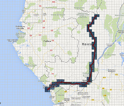
At the first stage, archival data of remote sensing of the Earth (RSD) to the territory of projected routes of oil product pipelines in the Republic of Congo were selected and obtained. The length of the route "Pointe-Noire – Brazzaville – Ye – Maloukou – Trechot” - 600 km, "Yie – Oyo – Ouesso" – 800 km. The shooting width is 4 km (+/- 2 km from the axis of the route)
On the sites where the archive data coverage was less than 100%, a new survey was ordered. In addition, the area of work was characterized by high clouds, in connection with which, to create orthophotomaps, not only a mosaic of current archived data and data from satellite imagery was used, but also pictures from several groups of spacecrafts with a resolution of up to 5 m.
The second stage is the formation of digital orthophotomaps based on archive and new remote sensing data in accordance with the terms of reference. SRTM with an accuracy of 20 m in height and 90m / pixel pitch was used as a high-altitude base.
The third stage of work was the formation of digital orthophotomaps for additional sites (based on archival images).
In conclusion, digital orthophotomaps were cut into 650 fragments measuring 5.5 x 5.5 km in size with corresponding cutting and linking of digital elevation models (DTM).
Scheme of operation of the oil pipeline pipeline Pointe-Noire – Brazzaville – Oyo – Ouesso with a branch Ye – Maloukou – Trechot (area of about 20,000 sq. Km.)
Схема-района-работ-нефтепродуктопровода.jpg
04
Result
The area of work was characterized by high clouds, in connection with which, to create orthophotomaps, not only a mosaic of current archival data and data from satellite imagery was used, but also images from several spacecraft groups with resolutions up to 5 m. Together with horizontals orthorectified remote data sensing allowed for successful planning of future engineering work.
This is the main infrastructure project of the Republic of the Congo, which will reduce the cost of transporting petroleum products, increase the safety of their transportation and ensure the sustainable development of remote areas of the Republic of the Congo.
Need satellite imagery or help choosing the right data?
Describe your task, area of interest, and desired outcome. We will check data
availability, assess new acquisition options, and propose the optimal solution in terms of timelines, cost,
and quality.
Fast feedback during business hours
We will select the best data for your task
Confidentiality guaranteed
Discuss the project
clients who trust us
25+ years in the geodata market
Мы используем Яндекс.Метрика и собственные Сookies для обеспечения наилучшего
опыта работы на нашем сайте, персонализации сайта для наших пользователей и аналитики.
Продолжая использовать сайт вы соглашаетесь с условиями
Пользовательского соглашения.
Request a call
Leave your contact details — we will get back to you during business hours, clarify the task and suggest suitable data or services.
Write to e-mail
Send a message, technical specification or task description. We will review your request and reply to the specified e-mail.
Fill in the order form
Describe the area, object and imagery requirements. We will check archive availability, the possibility of a new acquisition and offer a suitable option.