Creating a digital topographic plan of the 1:2000 scale
Creating a digital topographic plan of the 1:2000 scale
01
About the project
Topographic and geodetic works with the creation of a digital topographic plan (TSTP) of 1: 2000 scale (1: 500) and a vector-digital plan (TSC) to the projected area as part of the development of documentation on the territory planning for accommodating Universiade objects – Sopka and Raduga clusters.
Industry
Mapping
Customer
Russian Institute of Urban Development and Investment Development
End date
05/29/2019
02
Project goal
Topographic and geodetic works with the creation of a digital topographic plan (TSTP) of 1: 2000 scale (1: 500) and a vector-digital plan (TSC) to the projected area as part of the development of documentation on the territory planning for
accommodating Universiade objects – Sopka and Raduga clusters.
03
Completed works
The initial data for the execution of the contract were: digital topographic plans and vector-digital plans of 1: 2,000 scale with a 1-m section of the relief, made in 2014 using materials from aerial laser scanning combined with aerial photography; digital orthophoto plans with a scale of 1: 500; survey materials for the construction of clusters "Sopka" and "Raduga".
Innoter LLC, under the terms of the contract, provided the relevant cartographic materials of 1: 2000 scale used to prepare the graphic part of the territory planning documentation; as well as providing accurate, relevant, reliable materials and data (in graphic, digital and other forms) about the situation, existing structures and buildings and other planning elements.
Topographic and geodetic works on updating and creating cartographic material were performed in the following order:
1. Selection and acquisition of space imagery on an area of 250 hectares.
2. Creation of orthophotomaps on a scale of 1: 2000 over an area of 250 hectares.
3. Renovation (creation) of cartographic materials of 1: 2000 scale on an area of 250 hectares.
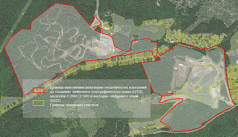
Area of the topographic and geodetic works on updating and creating cartographic material on Sopka and Raduga clusters.
According to the results of the work carried out, a report was prepared with a description of the topographic and geodetic works carried out on updating and creating cartographic material.
Рис.-1.jpg
04
Result
As a result of the implementation of the contract, Innoter LLC, within the timeframe specified by the customer, ensured the performance of topographic and geodetic works with the creation of a digital topographic plan of 1: 2000 scale (1: 500) and a vector-digital plan for the projected area as part of on the planning of the territory intended for the placement of the Universiade objects - Sopka and Raduga clusters.
Need satellite imagery or help choosing the right data?
Describe your task, area of interest, and desired outcome. We will check data
availability, assess new acquisition options, and propose the optimal solution in terms of timelines, cost,
and quality.
Fast feedback during business hours
We will select the best data for your task
Confidentiality guaranteed
Discuss the project
clients who trust us
25+ years in the geodata market
Мы используем Яндекс.Метрика и собственные Сookies для обеспечения наилучшего
опыта работы на нашем сайте, персонализации сайта для наших пользователей и аналитики.
Продолжая использовать сайт вы соглашаетесь с условиями
Пользовательского соглашения.
Request a call
Leave your contact details — we will get back to you during business hours, clarify the task and suggest suitable data or services.
Write to e-mail
Send a message, technical specification or task description. We will review your request and reply to the specified e-mail.
Fill in the order form
Describe the area, object and imagery requirements. We will check archive availability, the possibility of a new acquisition and offer a suitable option.
Order software
Order TK
Your application is accepted
We will contact you during working hours.
Выбрать город
Россия
Другие страны
Белоруссия
Contact via WeChat
Feliks Fokin
Open WeChat and scan the QR code to add the contact. On a phone, save the code and select it in the WeChat scanner.