Work Performed
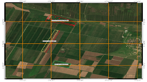
- Use of Sentinel-2A/2B satellite imagery with a spatial resolution of 10 m for the period 2018–2020
- Official cadastral data from the National Spatial Data System
- Software used: ScanEx Image Processor 5.1.47, NextGIS QGIS 4.7.0
- Verification and certification of satellite imagery to confirm data reliability
- Application of visual interpretation, atmospheric correction, orthorectification, and georeferencing methods
During the project, the Experts used nine high-quality Sentinel-2A and Sentinel-2B satellite images with a spatial resolution of 10 meters, acquired during key periods of the agricultural season. Technical processing included pansharpening to increase image detail, atmospheric correction to remove distortions, and orthorectification using a digital elevation model.
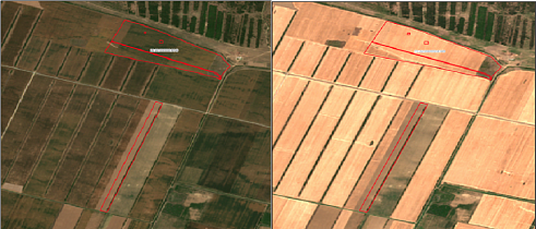
Specialized software enabled accurate visual interpretation and the creation of georeferenced polygons for the land plots under investigation. The method made it possible to trace surface changes from the light tones of plowed soil in spring to the characteristic appearance of harvested fields in autumn, confirming repeated land cultivation cycles over a three-year period.
The use of multispectral data in RGB channels made it possible to distinguish the spectral characteristics of different vegetation types and soil conditions. The image identification numbers contained complete technical information on acquisition parameters, including the MSIL2A processing level, ensuring a high level of data quality for forensic expert analysis.
Fig. 2. Comparative analysis of one of the land plots in May and July 2020, Stavropol Krai
Key agricultural operations are clearly distinguishable in satellite imagery due to characteristic spectral and textural surface features.
Key differences between field crops and vegetable crops are reflected both in their biological characteristics and in their agronomic requirements, which is critically important for accurate satellite image interpretation. Field crops, including cereals such as wheat, barley, and corn, as well as forage grasses and industrial crops, are characterized by continuous sowing and a homogeneous field structure, producing a relatively uniform texture in satellite imagery without pronounced row patterns. Vegetable crops demonstrate a fundamentally different structure — row planting with inter-row spacing, creating characteristic striping and mosaic patterns in satellite images.
Economic and technological factors also distinguish these crop categories. Transitioning from field crops to vegetable production requires specialized equipment, storage facilities, and qualified labor, creating high barriers for farmers. Vegetable crops are highly perishable and require immediate sale or specialized processing, unlike grain crops, which can be stored for extended periods. These differences in production cycles are reflected in the spectral characteristics of fields at different stages of vegetation development, enabling Experts to classify cultivated crop types more accurately when analyzing multi-year satellite datasets.
Analysis of satellite image time series provides continuous monitoring of agricultural operations and vegetation dynamics throughout the growing season. Satellite systems, including Sentinel-1 and Sentinel-2, make it possible to obtain regular time-series data with sufficient spatial resolution for detailed tracking of changes across land plots. Sequential image analysis allows Experts to identify not only whether agricultural activities took place, but also their chronological sequence, the duration of cultivation cycles, and their compliance with agronomic requirements.