of geospatial solutions
Sat-Sun: Non-working days
US Space Program
Foundations of US Space Policy
In the United States, remote sensing policy is determined by the government, which in recent years has taken steps to increase the satellite constellation of dual-use information systems to enhance and protect its security and to strengthen the US's leading position as a global leader in the development and use of remote sensing systems (RSS). The main efforts of state regulation in the US RSS sector are aimed at promoting the development of market mechanisms.
The fundamental document in this area is the directive on space policy regarding the use of commercial RSS, approved by the US President on April 25, 2003. This document replaced Presidential Directive PDD-23 of March 9, 1994, which outlined the foundations of US policy regarding foreign customers' access to the resources of American RSS [3].
The new policy is aimed at further strengthening the world's leading position of American companies and covers the following areas of activity:
- licensing activities and operations of RSS;
- using RSS resources for the interests of US defense, intelligence, and other government agencies;
- access of foreign customers (governmental and commercial) to RSS resources, export of technologies and materials for RSS;
- intergovernmental cooperation in military and commercial space imaging.
The main goal of the policy is to enhance and protect US national security and interests on the international stage by strengthening leading positions in RSS and developing national industry. The policy's objectives are to stimulate economic growth, protect the environment, and strengthen scientific and technological superiority.
Remote Sensing Materials
The new directive also addresses the commercialization of remote sensing systems. According to experts, without commercialization, RSS technologies will not only fail to develop but will also set the US (and any other country) back from leading positions in the world. The US government believes that space imaging materials become demanded products for government agencies' needs, obtained on a commercial basis from RSS. One of the main goals is to free the National Intelligence Community from a large volume of requests for such products from various US agencies. Another important task of the new space policy is the commercialization of RSS to further strengthen the leading position of American companies - operators of space remote sensing systems.
The directive outlines the licensing procedure for RSS activities in the interests of the Department of Defense, intelligence, and other agencies such as the State Department, and sets certain restrictions for foreign customers of RSS products and the export of technologies and materials. It also establishes the basis for intergovernmental cooperation in military and commercial imaging.
The steps taken by the US government ensure the enhancement and protection of national security, as well as the creation of favorable conditions for the country on the international stage by strengthening America's leading position in RSS and developing its own industry. To this end, the government has granted extensive powers to the National Imagery and Mapping Agency (NIMA), which is part of the US intelligence community. NIMA is functionally responsible for collecting and distributing imagery obtained from RSS among government agencies and foreign consumers, which is only done with the approval of the US State Department. The Department of Commerce and NASA are tasked with coordinating requests for RSS products in the commercial sector. The same imagery is to be used by various agencies interested in the same areas of imaging.
The Department of Commerce, Department of the Interior, and NASA define civilian needs in the RSS field. They also allocate appropriate funds for project implementation. NIMA assists in implementing civilian government RSS programs. This organization is also the lead in developing action plans for the new space policy, which involves the Secretary of Defense, Secretary of Commerce, State Department, and the Director of Central Intelligence (who is also the CIA Director).
These issues are addressed legislatively, through the discussion and adoption of laws. Government RSS systems, such as Landsat, Terra, Aqua, will be used for defense and intelligence tasks when obtaining information via commercial RSS systems is not economically feasible. NIMA creates conditions for the US industry to gain competitive advantages. The US government guarantees support for the RSS market development and retains the right to restrict the sale of imagery to certain countries to maintain US leadership in RSS. The directive stipulates that the CIA and the Department of Defense should monitor the development of RSS in other countries to ensure that US industry does not lose its leading position in the global RSS market.
The US government does not prohibit its Department of Defense from purchasing any imagery materials from commercial firms. The direct benefit is clear: no need to launch a new or retarget an existing RSS satellite to the area of interest, thus achieving high operational efficiency. This is eagerly done by the US Department of Defense, thereby promoting the development of commercial RSS structures [3].
Key ideas of the new space policy:
- It is legislatively established that US RSS resources will be used to the maximum extent for defense, intelligence, internal and international security, and for civilian users;
- Government RSS systems (e.g., Landsat, Terra, Aqua) will be oriented toward tasks that cannot be effectively addressed by RSS operators due to economic factors or national security interests;
- Establishment and development of long-term cooperation between government agencies and the US aerospace industry, ensuring an efficient licensing mechanism for RSS operations and export of RSS technologies and materials;
- Creating conditions for the US industry to gain competitive advantages in providing RSS services to foreign governmental and commercial customers.
The new RSS policy is the first step by the Bush administration to review US space policy. It is evident that the document's adoption was actively lobbied by aerospace corporations, who welcomed the new rules. The previous policy, defined by PDD-23, contributed to the emergence and development of high-resolution commercial means. The new document guarantees government support for RSS market development and stipulates that new commercial projects will be developed considering the needs of civilian and defense agencies.
Another important aspect is that the state becomes an "international promoter" of commercial RSS information. Previously, the structure of imagery information sales by commercial operators was dominated by defense and other government customers. However, the scale of purchases was relatively low, and the RSS materials market developed slowly. In recent years, with the advent of high-resolution RSS (0.5-1 m), the situation has changed. High and medium resolution commercial systems are now considered an essential complement to military space systems, enhancing the efficiency of orders and overall system productivity, delineating functions, and expanding the circle of imagery information users.
Over the past 5-7 years, commercial RSS imaging has become a crucial source of up-to-date and high-quality imagery for several reasons:
- The resources of military reconnaissance systems are limited due to the expanding range of tasks and the number of users, reducing the operational efficiency of survey tasks;Position on the strategic intentions of the US national geospatial intelligence system
In January 2004, the American National Geospatial-Intelligence Agency (NGA) published a conceptual document entitled "Position on the Strategic Intentions of the National Geospatial Intelligence System."
The document was developed under the leadership of NGA Director Lieutenant General USAF (Ret.) James Clapper, whose tenure was associated with revolutionary changes in geospatial data information. The NGA Director identified key threats that the agency aims to counter: international terrorism, proliferation of weapons of mass destruction, and regional instability threatening US interests. In technological terms, according to the NGA Director, the agency must be prepared for explosive growth in the volume, speed, and types of information [5], [7].
The document outlines four main strategic goals of the geospatial intelligence system, summarized as follows.
The first goal concerns the core task of information provision, requiring the creation of an integrated and interconnected environment for analysis and decision-making focused on uncovering the capabilities and intentions of targeted entities.
The second goal concerns the development of NGA's interactions with strategic partners and ensuring leadership in the national geospatial intelligence system. It is intended to establish common standards and metadata, expand partnerships and strategic alliances with national agencies, military commands and services, industrial corporations, and foreign allies.
The third goal addresses personnel policies, issues of recruitment, and professional development of personnel with the knowledge and skills necessary to counter current and future threats. It is necessary to implement standards of professional competence and innovative methods of retraining personnel to enhance the level of analytical processing of materials.
Finally, the fourth goal defines the approach to the development of advanced geospatial intelligence technologies. Tasks include the integration of various sensors and data collection platforms, transition to digital network architecture for rapid data collection and dynamic data exchange, and ensuring a dynamically expanding infrastructure of the geospatial intelligence system to meet the growing volumes, speeds, and data formats.

Figure 1 - Satellite image - raster image
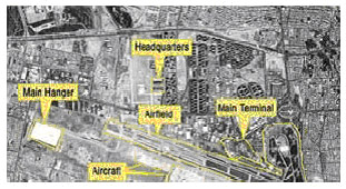
Figure 2 - Identification of targets and objects
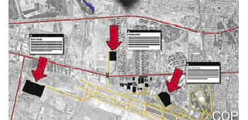
Figure 3 - Real-time operational situation display
The primary task of the NGA, one of the 15 organizations comprising the US Intelligence Community, is to provide geospatial intelligence data in the interests of national security. In its activities, the NGA occupies an intermediate position between the developer and operator of space systems—the National Reconnaissance Office (NRO), on the one hand, and the consumers—military commands and services of the country's special services, on the other. Therefore, for a long time, the effectiveness of the NGA's work depended on the activities of the NRO, which was a monopoly in the field of creating new reconnaissance satellite systems but did not perform its functions in the best way [6].
Under the leadership of NGA Director Clapper, large-scale purchases of high-resolution satellite images from commercial companies are associated with the agency's activities. This practice allows simultaneously reducing the load on the so-called "national technical means" (military satellites) and supporting the development of the American GEOINT industry. Thus, the NGA disrupted the NRO's management monopoly on reconnaissance satellite orders. How successful this practice will be will become clear in the near future: launches of new super-satellites are expected in 2007.
In the future, the NGA plans to expand the scale of information purchases from commercial operators. According to General Clapper, "commercial images have proven their information utility and value" in practice. The commercial GEOINT industry serves as a kind of insurance policy for secret satellites operated by the NRO, especially given the problems encountered in developing new Future Imagery Architecture (FIA) reconnaissance satellites. The NGA Director stated that commercial satellites will become a fundamental component of the FIA system architecture.
Space military reconnaissance program
At the end of 2005, the American non-governmental organization Union of Concerned Scientists (UCS) published a database of active spacecraft compiled from open publications. The UCS database includes over 800 active satellites. At that time, there were 413 American satellites of various purposes in low Earth orbits. All other countries in the world together had only 382 satellites. Russia had 87 still functioning orbital vehicles, and China had 34. The research summarized information about active vehicles in 21 parameters—from orbits to their intended purposes. The study included 40 secret American reconnaissance satellites of the National Reconnaissance Office (NRO), including those known as Lacrosse-4, Mercury, Trumpet, and Orion. Even those whose names are unknown are listed [7], [8].
In February, the US Department of Defense published a report on the prospects for the next 4 years. In the field of space technology, the US defense department confirmed its intention to maintain a technological advantage over all countries by at least one technological generation. Plans include developing rapid access to space, ensuring high survivability of space systems by improving space control means and spacecraft protection.
As a result, the US has created the largest group of reconnaissance satellites in orbit in its history. In January 2006, amateur astronomers united in an international network, based on optical observations, established that the US radar reconnaissance satellite Lacrosse-2 made a slight correction to its orbit. This curious fact means that the world's longest-serving low-orbit reconnaissance satellite, launched in 1991, showed "signs of life" [7].
For decades, the US IMINT reconnaissance system has included two types of satellites: optical telescopes KeyHole (or KH - "keyhole", referred to as "Improved Crystal" KH-11 or KH-12 in the press) and radar reconnaissance Lacrosse. According to press reports, the spatial resolution of optical equipment is about 10 cm, and radar equipment is less than 1m. In addition, according to open publications, a stealth satellite with low radar and optical visibility, Misty-2, was launched into orbit in 1999 and can capture images of objects without being noticed by space surveillance stations of other countries. The first Misty-1 satellite was launched in 1990 and is likely no longer in use.
With clarifications made by optical observers and publications in the magazine "Space News," the number of the US IMINT reconnaissance group reached a record size of 9 satellites, including 4 KeyHole, 4 Lacrosse, and one secret stealth satellite Misty-2. All listed secret satellites were observed by astronomers except Misty-2, which was lost to observers immediately after launch. The number of Earth observation IMINT satellites of the US increased to a record level in 2005 due to two successful launches of KeyHole and Lacrosse-5 satellites. No old spy satellite has been deorbited, indicating their residual operational capability.
Of course, not all satellite capabilities are equivalent, but the expanded IMINT group provides high redundancy, high frequency of viewing, and allows for increased volume of space information collected on objects worldwide. In addition to data obtained from military satellites, the National Geospatial Intelligence Agency (NGA) spends almost $100 million annually on purchasing high-resolution satellite images from commercial satellites Ikonos-2, QuickBird-2, and OrbView-3 operated by GeoEye and DigitalGlobe operators. The group is complemented by military experimental satellites STP-R1, MTI, and SINDRY with Earth observation equipment. Thus, in addition to the main IMINT group, 5-6 satellites collect geospatial information.
Maintaining a 9-satellite IMINT group in orbit requires not only significant financial expenses but also corresponding infrastructure for relay, reception, processing, and archiving of a huge volume of spatial data. It is not excluded that such an expansion of the IMINT space segment is associated with preparation for the launches of the promising multisatellite FIA (Future Imaging Architecture) reconnaissance system. Despite significant delays in the development of new FIA satellites (initially planned launches were supposed to start in 2005), the ground information processing segment was created and put into operation in 2003 as part of the Mission Integration and Development (MIND) program. MIND system uses internet protocols HTML, CGI, TCP/IP, JAVA 1, and commercial equipment Cisco and NT for data exchange.
Under the GeoScout project, the NGA creates ground infrastructure for joint ordering, processing, automated analysis, and preparation of various geospatial products based on data from national reconnaissance satellites, commercial observation vehicles, and airborne platforms collecting visual information. The main areas of application for commercial data include the development of high-precision detailed maps and digital terrain models, determination of coordinates of stationary and low-mobility targets, control of results of missile-bomb strikes. The accuracy of the coordinate attachment of stationary objects by commercial images is several meters, which is sufficient for the use of high-precision weapons with satellite navigation equipment GPS (JDAM and JSSOW families of strike weapons). Tactical guided weapons with combined GPS/IMU receiver can provide the aiming accuracy of 2-3 m, which is the value of combat characteristics of new American combat aircraft of F-22 Raptor and F-35 Lightning II.
The American geospatial intelligence system, based on the use of global information sources, ensures the combat capabilities of new electronic and information warfare systems. Thus, the increase in the number of reconnaissance satellites is associated with the strategic interests of Washington to maintain the lead in the arms race in the field of satellite reconnaissance and the development of new reconnaissance equipment and electronic systems of information warfare in orbit. One of the 7 tactical guidance satellites of the NAVSTAR / GPS military navigation system (with frequency and positional data transmission) will allow determining the current coordinates of air, sea, and ground targets on the principle of "dual use." At present, American reconnaissance satellites do not use information on the targets of a 3rd party and are not authorized to determine their precise coordinates. NAVSTAR / GPS military navigators are used for direct guidance of the low-precision JDAM and JSSOW air bombs (smart bombs and cruise missiles). There is no need for a separate determination of the precise position of the target. The implementation of tasks in the event of the use of equipment is carried out with the help of a specialized installation, which determines the coordinates of ground targets on the Earth's surface.
The second contract of the NGA geospatial intelligence agency's NextView series was won in September 2004 by a group of companies led by GeoEye. The development of the dual-purpose satellite GeoEye-1 is carried out by a cooperation of companies: General Dynamics (platform), IBM (processing system), Kodak/ITT Industries (camera), MDA (ground segment). The total contract value amounts to $500 million, with approximately $209 million allocated for the satellite manufacturing.
Structurally, the GeoEye-1 satellite is designed as a telescope with service subsystem blocks around it and solar panel arrays on the sides. The satellite will provide simultaneous panchromatic and multispectral imaging with spatial resolutions of 0.41m and 1.64m (the predecessor OrbView-3 cannot combine both imaging modes) in a swath width of 15.2 km at an altitude of 684 km. Telescope pointing can deviate up to 600 from nadir. The daily capacity of the equipment is 700,000 km², and for global coverage, a recorder with a capacity of 1200 Gbit is installed on board. Images are transmitted to Earth via two X-band radio links at speeds of 150 and 700 Mbit/s. Radiometric resolution of images is 11 bits/pixel. The estimated operational lifespan is more than 7 years (fuel reserve for 10 years). In 2007, the satellite is planned to be placed in a morning sun-synchronous orbit (local time of equator crossing 10:30) and, according to preliminary forecasts by specialists, will operate until 2015 [11]. The external appearance of the GeoEye-1 satellite is shown in Figure 5.
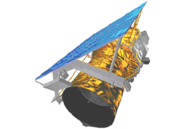
Figure 5 - GeoEye-1 Satellite
GeoEye plans to use its existing international network of 12 ground receiving stations, including three stations in Germany, Poland, and Turkey responsible for receiving images from Europe and Russia, for the operational collection and distribution of information from the GeoEye-1 satellite.
Under the restrictions of U.S. national legislation, satellite images for customers outside the U.S., including Russia, will be supplied with degraded resolution of up to 0.5 m and with a time delay of at least 24 hours.
GeoEye and DigitalGlobe operators will be able to use nearly 50% of the onboard imaging resources of super-satellites for commercial purposes. Considering that the total performance of the super-satellite system is 10 times higher than the capabilities of the current constellation, the proposal of U.S. geospatial products with submeter resolution on the global market will increase significantly.
Ultra-detailed images will find application in the development of large-scale maps and terrain plans, various thematic GIS, urban planning, construction of roads, communication lines, pipelines, and other infrastructure objects. In case of sustainable development of the consumer market for geospatial products based on ultra-detailed satellite images, millions of people such as car drivers equipped with navigation computers, users of various thematic GIS with detailed topographic bases, designers, builders, and insurers may become users.
The next logical step in the development of the remote sensing satellite market is the launch of satellites with ultra-high resolution (up to 0.25 m). Previously, images with such resolution were provided only by U.S. and Soviet military satellites.
SI and DigitalGlobe companies have applied to the licensing authority - the National Oceanic and Atmospheric Administration (NOAA) - for a license to launch a satellite with a resolution of 0.25 m (the companies already have licenses for systems with resolutions of 0.5 m and 0.4 m). It is obviously inferred that the optical-electronic systems of U.S. military reconnaissance satellites already have a higher resolution capability than 0.25 m, if commercial firms plan to use optical-electronic equipment with such high parameters and capabilities. According to analysts, the emergence of ultra-high resolution remote sensing satellites will aim to redistribute revenues between aerial imaging materials and space data markets in favor of the latter. According to estimates, the global aerial imaging data market is about $3 billion, while the space materials market is less than $500 million. Improving resolution to 0.25 m will increase the significance of commercial optical information and for military consumers.
So far, the major competitors in the remote sensing satellite market from countries such as Europe, Russia, Japan, Israel, and India have no plans to create remote sensing satellites with ultra-high resolution. Therefore, launches of such devices in the United States will further develop the market and strengthen the positions of American geospatial data product operators - super-satellite operators.
In addition to the ambiguous status of commercial satellites, the world is concerned about the uncertainty of U.S. policy regarding access for ordinary users to another vitally important satellite system - GPS. The selective access regime that restricted the accuracy of positioning for ordinary people was turned off by decree of President Clinton on May 1, 2000. However, President Bush has long been in the White House and could reintroduce this regime in order to combat "global evil."
Lockheed Martin announced the completion of the modernization of the Global Positioning System (GPS) data processing and modeling software, which will increase system accuracy by 10–15% for all GPS equipment users. The modernization was carried out under the Legacy Accuracy Improvement Initiative (L-AII) program through joint efforts of the U.S. Air Force and the National Geospatial Agency (NGA).
The improvements in GPS system parameters were achieved through the phased integration of the Air Force's standard operational control network of 6 ground stations with the NGA's monitoring station network located worldwide. The unified ground network of 17–20 stations enables monitoring of each of the 23 operational GPS satellites simultaneously by two to three stations. As a result, the time interval between the appearance of malfunctions and their elimination is reduced, the accuracy of determining the satellites' orbit parameters improves, and more accurate ephemeris and time signals are transmitted to consumers.
Before the implementation of the joint L-AII program, GPS constellation satellites were served only by six Air Force stations and could be out of radio visibility for several hours. Additional NGA stations in Eurasia are located in the United Kingdom, Bahrain, and Korea. The main control station of the combined ground station network is located at Schriever Air Force Base (Colorado).
Increasing the GPS system accuracy by 10–15% will affect all GPS receiver users worldwide, both military and civilian. No modification of consumer equipment will be required. Although some sources report that accuracy for military consumers will improve by 35%.
What do such changes in the state policy of the most powerful space power of the modern world mean for the global market? The emergence of competition in the high-resolution satellite system market has already led to a significant reduction in the cost of satellite images. The cost of panchromatic (black-and-white) satellite images with a resolution of one meter has already decreased from over $30 per square kilometer to $5 per square kilometer. Obviously, this process will accelerate further with the appearance of similar foreign systems.
Such a dramatic reduction in prices for products essential for modern industry would only be welcomed. However, the widespread use of remote sensing systems is hindered by concerns that unpredictable U.S. policy could intervene in business at the last minute. Then long-term promising projects could collapse overnight. The drop in satellite image prices will make satellite system operation less profitable. This, in turn, will complicate or make it impossible to compete against countries or blocs that cannot provide state support to the industry. On the other hand, the stakes in this area of activity are higher than ever.
There are reasons to believe that the necessity of life will push more and more states towards the development of their own remote sensing systems or participation in international projects for their development. The creation of high-resolution remote sensing satellite systems is one of the few areas where Russia can still have a significant say and become a global leader in an important and advanced area of modern high technology.
Space Programs of European Countries
In recent decades, Western European countries have begun to play an active role in space exploration and development. Western European countries from the very beginning sought to unite their scientific and technical efforts, production and test facilities, and financial capabilities, initially based on the European Space Research Organization and later within the framework of the European Space Agency (ESA) (European Space Agency). ESA was established in 1975, and its members are Belgium, United Kingdom, Denmark, Ireland, Italy, Netherlands, France, Germany, Switzerland, and Sweden. Austria and Norway are observers in ESA. Germany (26%) and France (21%) play the leading role in ESA financing. The agency's headquarters is located in Paris.
Cooperation in space research is considered a priority direction in the European Union (EU). In the near future, Europe may rank third in the world in terms of appropriations for space programs. ESA's main tasks include the creation and operation of space facilities on a commercial basis, and ESA members can participate in agency programs by selection and determine their share of costs for specific projects. ESA's annual budget for the 2001–2005 period is planned to be approximately 2 billion euros, and the agency employs about 1500 people.
ESA's specific projects are designed to conduct a detailed study of outer space, the Earth's atmosphere, and natural resources and the creation of communication, meteorological, and television systems, including telecommunications systems. All ESA programs have commercial applications. The successful launch of the Columbus orbital module, for example, will enable European scientists to conduct the necessary research and experiments to get firsthand knowledge of the impact of space flight on the human body. The international "Artemis" project is a telecommunications system with a large number of telecommunication channels based on the construction of a communications satellite fleet. And after it has been orbiting for five years, "Eureca" has successfully provided 15 scientific projects with scientists from around the world.
ESA's plan is to develop global navigation systems to compete with the US global positioning system. GPS. The European system of navigation satellites Galileo will have 30 satellites and provide the planet with GPS accuracy. The first of these will be sent to a geostationary orbit in 2006. These systems for advanced EGNOS and GPS will have high communication capabilities with two-way information transmission. Through increased security, low cost, and exceptional benefits, Galileo will be the central part of the European integrated satellite communication system. And for many European users, it will be their satellite navigation system. No matter the last point, though, of the European satellite communication system to work, I. themselves have a good number of advantages. in addition to the dataGridViewTextBoxColumn we had project This
On SPOT 5, the resolution of three multispectral channels (visible and near-infrared ranges) was enhanced to 10 m, and the panchromatic channel to 5 m. Images in these channels are formed by two separate CCD lines, vertically and horizontally shifted by half a pixel (2.5 m on the ground) in the focal plane. Funding for the creation of SPOT 5 was provided by CNES, SSTC, and SNSB. Additionally, Italy and Spain indirectly contributed to the satellite's development through systems developed for the European optical reconnaissance program Helios 2, which were also used on SPOT 5.
The Doppler Orbitography and Radiopositioning Integrated by Satellite (DORIS) radar is used to determine precise satellite orbit parameters using signals from the International DORIS Service (IDS) network of ground beacons. The network includes approximately 60 radio beacons in 30 countries across all continents. The IDS network was initiated by CNES, the French Geodetic Research and Study Center (GRGS), and the French Space Agency for Surveying, Mapping and Remote Sensing (IGN). With DORIS, orbit accuracy can reach 10–20 cm when onboard data processing is performed over a 24-hour observation cycle, and accuracy can be further improved to several centimeters when data is processed on Earth. SPOT 4 and 5 are equipped with the Diode navigation system as part of DORIS, allowing real-time orbit parameter measurements. On SPOT 4, measurement accuracy is 5 m for all three axes. An upgraded version of the Diode system software developed for SPOT 5 will achieve accuracy of less than a meter in real-time mode.
On September 9, 2012, the innovative satellite SPOT-6 was launched into a sun-synchronous orbit by an Indian PSLV rocket from the Satish Dhawan Space Centre on Sriharikota Island. SPOT-6 offers higher capabilities compared to its predecessors—SPOT 4 and SPOT 5—allowing Earth observation with resolutions up to 1.5 m in panchromatic mode and up to 6 m in multispectral mode.
Spot-6 and 7 are two identical high-resolution optical Earth observation satellites. Spot-7 is scheduled for launch in 2014. The imaging swath width for SPOT 6, like its counterpart SPOT 7, is 60 km. Each of the SPOT-6 and -7 satellites can daily cover up to 3 million square kilometers.
The satellites represent a new generation of the SPOT series. The decision to create them was made by the consortium EADS Astrium in 2009 to ensure continued high-resolution imaging for years ahead (up to 2023). SPOT-6 and -7 will replace SPOT 4 and SPOT 5 satellites launched in 1998 and 2002, respectively.
The new generation SPOT satellites, together with the Pleiades satellite group, form a unified system. Four satellites—Pleiades-1/2 and SPOT 6/7—will be placed in the same orbital plane, evenly spaced by a phase angle of 90° from each other. This allows commercial and government customers to obtain imagery of the same area twice a day in a wider high-resolution band using SPOT satellites and in a detailed super high-resolution mode using Pleiades satellites.
The reception and processing system includes two main stations in Toulouse, France, and Kiruna, Sweden. These stations can receive telemetry data recorded on onboard recorders or received directly within their approximately 2500 km visibility radius, with themselves as the center. Additionally, there are 22 direct reception stations that only receive telemetry data within the visibility circle. Each station effectively manages its visibility zone according to the satellite resources assigned by SPOT Image.
On July 7, 1995, the 75th launch of the Ariane rocket successfully launched the payload of the “Helios-1A” (Helios-1A) satellite. “Helios-1A” became the 100th satellite launched into orbit by the “Ariane” series rocket and the third military satellite launched by a European launcher (the first two were British military communication satellites “Skynet-4B” and “Skynet-4C” in 1988 and 1990, respectively) [17].
“Helios-1A” is the first optical reconnaissance satellite manufactured and launched in Europe. The “Helios” program began as purely French and was particularly stimulated by the experience of the Persian Gulf War, when French forces were completely dependent on the United States for space reconnaissance information. Subsequently, France turned to ESA partners with a proposal to participate. Italy and Spain responded to this proposal by taking on 14% and 7% of the funding for the “Helios-1” project, respectively. The main developer of the “Helios” satellite was the French company “Matra” (which has since merged with the British company “Marconi Space” into the international group “Matra Marconi Space”).
The satellite, weighing 2537 kg, was structurally based on the basic block of the SPOT remote sensing satellite developed by “Aerospatiale”. The optoelectronic system, also developed by “Aerospatiale”, provides maximum Earth surface resolution up to 1 meter. (SPOT-1..3 satellites launched so far provide a resolution of up to 10 meters, albeit at a slightly higher orbit). In addition to the main developers, prominent in the production cooperation were companies “Thomson-CSF”, which supplied linear assemblies of charge-coupled device (CCD) image sensors with 4096 and 2048 elements, “Sextant Avionic” (video system), “Schlumberger Industries” (onboard tape recorders), SAGEM and SODERN (electronics).
The overall management of the “Helios” program is carried out by the Rocket and Space Management of the General Directorate for Armaments (Delegation General de I'Armament — DGA) of the French Ministry of Defense, but the National Center for Space Studies (CNES) will play a key role in managing the satellite. Requests for imaging from Italian, Spanish, and French commands will be submitted to the French airbase at Creil. There, with the participation of military representatives from Spain and Italy, an integrated imaging program will be compiled (in which each side has the right to a share corresponding to its share of project financing). The coordinated program will be transmitted daily to the CNES center in Toulouse, which manages “Helios-1A”, and from there will be transmitted to the receiving stations equipped in each participating country. The French receiving station is located in Colmar, near the borders with Germany and Switzerland, the Italian one is in Lecce, in the south of the country, and the Spanish one is in Maspalomas, in the Canary Islands. In addition, the Western European Union station in Torrejon (Spain) will also process images from “Helios” for use by WEU countries.
The total cost of the program, including the manufacture of two satellites and ground stations in three countries, is 10 billion francs (2 billion $). In the future, it is planned to create an improved satellite “Helios-2”, which will have a more advanced visible range optical system and an additional infrared observation system. It is planned to manufacture two “Helios-2” satellites, the first of which was planned for launch in 2001, but was launched on December 22, 2004, by an Ariane rocket into an orbit approximately 600 km high. According to experts, the launch of Helios 2A indicates that France is gradually, but steadily shifting the focus of its military policy from NATO to the European Union, including eliminating military-technical dependence. The main areas in which European countries are fatally dependent on America are military transport aviation, satellite reconnaissance, global navigation systems, as well as AWACS reconnaissance and targeting aviation systems [17].
Europe is only at the very beginning of a long path that will eventually eliminate dependence on NATO in these matters. However, active steps are already being taken in this direction. Last year, the European Union approved $4 billion for the purchase of military transport aircraft from Airbus. The same amount was allocated for the development of the European global navigation system "Galileo".
France currently operates two Helios satellites, which allow obtaining Earth surface images with a resolution of about 1 meter. Such images allow, for example, identifying the types of aircraft parked at an airfield. According to French military sources, the new Helios 2A satellite will have a resolution more than four times better. Images obtained with its help will not only identify the type of aircraft, but also determine what exactly is mounted on its external suspension - rockets or fuel tanks. The presence of an infrared channel will allow obtaining images not only at night, but also to determine, for example, the temperature of a tank parked at the airfield.
In accordance with intergovernmental agreements between France, Germany, and Italy, Paris will receive synthetic aperture radar (SAR) data from the SAR-Lupe and COSMO systems in exchange for similar data deliveries from the HELIOS-2 optical imaging satellites, and in the future, from PLEIADES. Official data on the spatial resolution of the HELIOS-2 optical equipment are classified, but according to statements by French military officials, this figure is "several tens of centimeters," i.e., 30–40 cm. A clear advantage of radar satellites is the ability to capture images in any weather and lighting conditions.
Germany
Germany conducts its space program within the framework of bilateral cooperation with the USA, France, and the European Space Agency (ESA) under the leadership of the Aerospace Research and Experimentation Center. Although Germany does not have its own launch vehicles, it actively participated in the development of the Western European Ariane rocket, which incorporates a third stage of German manufacture using oxygen-hydrogen.
Expenditures on space are quite significant. For example, in the late 1980s, they amounted to 502 million marks. By 2000, these expenditures are planned to increase to 27 billion marks, with 17 billion marks earmarked for joint programs with ESA and 10 billion marks for national programs.
For a long time, Germany was in the shadow of the leaders in the space information market – the USA, France, and India – modestly participating in pan-European Earth remote sensing programs. The new German satellite TerraSAR-X will make Germany a monopolist in the market for high-detail radar products previously available only to special services.
Following the successful launch of TerraSAR-X, Germany became the first country to launch a civilian satellite with radar with a spatial resolution of up to 1 meter. Today, similar radars are operated only by the US military (LACROSSE reconnaissance satellites) and Japan (IGS-1R satellite). In the race to create various types of space radars (military, civilian, dual-use), Italy, Russia, Israel, and Canada are also participating, but German products from the TerraSAR-X satellite were the first to appear on the market.
Germany was able to surpass competitor countries in creating high-detail space radars thanks to the introduction of a progressive public-private partnership scheme, combining the financial resources of the DLR space agency with private initiative and technological developments of the European aerospace giant EADS Astrium. The total cost of the satellite was €130 million, with €102 million provided by the DLR agency. The project development took 4 years. The advantages of the public-private partnership are evident when compared to the similar British TerraSAR-L satellite with L-band radar, which is being developed concurrently with the TeraSAR-X project but under the traditional scheme – under the leadership of UK government structures and ESA – and therefore will not be launched until 2008 [18].
Following Canada and the USA, Germany is developing its own Earth observation systems for both Bundeswehr and civilian users. On August 30, the German Aerospace Center (DLR) and Astrium GmbH signed a contract to create the TanDEM-X radar satellite. The new satellite with a design life of 5 years is almost identical to the already manufactured first German radar apparatus TerraSAR-X, which was launched in 2007 by the "Dnepr" rocket. As a result of launching the TanDEM-X satellite in 2009, a constellation of two radar satellites will be formed in orbit, performing a joint (tandem) flight at a small distance from each other. Over three years, the tandem pair of twin radar satellites will map the entire Earth's surface (150 million square kilometers) to develop a global digital elevation model (DEM) with unprecedented accuracy and detail (height error 2 m, step 12 m). Currently, the freely available American DEM has a 90 m step and height errors of 16 m, which does not cover the entire Earth's surface.
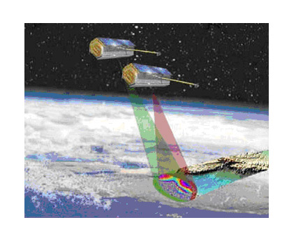
Figure 7 - TerraSAR-X and Tandem-X Satellites
With a total cost of €85 million, the project is funded through a public-private partnership, with €56 million contributed by the DLR agency, €26 million by Astrium, and an additional €3 million expected from the sale of excess payload mass. The responsibility for using the acquired space information for scientific purposes lies with the DLR's Institute for Microwave and Radar Technology, while the commercial marketing of radar information will be handled by Infoterra GmbH, a subsidiary of Astrium, which will also manage part of the operational costs for orbiting TanDEM-X. Under the agreement between the two German organizations, the DLR is responsible for overall project management, ground segment creation, data collection, archiving, and processing, calibration, and DEM creation, as well as satellite management for 5 years. Astrium is responsible for developing, manufacturing, and launching the TanDEM-X satellite.
Germany is also creating a military radar reconnaissance system consisting of five SAR-Lupe mini-satellites. The system is designed to provide operational imaging of any area on Earth regardless of weather conditions with a maximum resolution of up to 0.7 meters. The first mini-satellite, weighing 770 kg, was launched into orbit by the Russian "Cosmos-3M" rocket from the Plesetsk cosmodrome on December 19, 2006. The foundation of this satellite system lies in France gaining access to German SAR-Lupe satellite capabilities in exchange for Germany accessing the French HELIOS-2 optical system. The creation of this satellite orbital system is Germany's first large-scale space program openly implemented for military purposes.
The SAR-Lupe system, which plans to deploy an orbital group of five satellites between 2006-2008, is intended for high-resolution radar Earth observation. The architecture of the SAR-Lupe orbital segment is shown in Figure 8 [19].
Figure 8 - Architecture of the SAR-Lupe Orbital Segment
By deciding to implement the SAR-Lupe program, Germany contributes to bridging the existing gap in global reconnaissance means at both national and European levels. Germany consistently adheres to a policy of cooperation and will integrate its national capabilities with pan-European ones. In this regard, cooperation with France is the first and most important step, and all interested countries can participate in this cooperation.
The main contractor developing SAR-Lupe is the small company OHB-System AG, headquartered in the technological park of Bremen. The company occupies one of the leading positions in the world (and the leading position in Germany) in the development of lightweight satellites, equipment for manned space vehicles, reconnaissance and monitoring technologies, as well as security provision. According to the official press release of OHB-System AG, the company's total number of employees is about 300, with 160 working at the main office. Subcontractors of the project include Alcatel Space, EADS Dornier, Saab Ericsson Space, THALES, and the German COSMOS International.
The SAR-Lupe system will consist of an orbital group including five lightweight satellites and a ground segment, providing satellite management, data collection, processing, and use of the information collected. It is expected that this orbital group of satellites will quickly obtain high-detail images of the required territory across almost the entire globe, regardless of time of day, cloud cover, or other aerosols.
The foundation of this system is France gaining access to the SAR-Lupe system in exchange for Germany accessing the French HELIOS-2 optical system. It is expected that the first elements of the system will be created by the end of 2005, when the HELIOS-2 system becomes operational [19].
Italy
The Italian space research program is based on the use of US launch vehicles ("Scout"), the European Space Launcher Development Organization ("Europa-1"), and the European Space Agency ("Ariane").
The leadership of Italy's space programs is entrusted to the Commission for the Study of Space Issues and the Aerospace Research Center. The Italian Space Agency was established in 1988. In terms of space expenditures, Italy ranks third in Western Europe after France and Germany.
Launches under Italy's space program were conducted until 1975 from the unique floating San Marco spaceport, established in 1964. Italy's first artificial satellite, "San Marco-1," was launched by a US Scout rocket in December 1964. The Italian floating launch complex "San Marco" is located in the Indian Ocean, 5.5 km off the coast of Kenya. It consists of two platforms resting on the seabed: the launch platform "San Marco" and the control platform "Santa Rita." The geographical location of the "San Marco" launch platform is extremely advantageous for launching satellites into equatorial orbits. The proximity of this launch complex to the equator allows rockets to carry heavier payloads into orbit compared to launches from other locations.
In 1992, for geodetic research, the MTCS "Space Shuttle" launched the satellite LAGEOS-2 into low Earth orbit, which was then transferred to a planned orbit of 5900 km altitude using the Italian solid-fuel stage IRIS.
For Earth remote sensing, Italy has developed the X-SAR program in collaboration with DARA (Germany) and NASA (USA) to develop SAR with synthetic aperture radar. Two launches were carried out in April and September 1994. The data obtained from these launches are the subject of study for national and international research organizations.
According to forecasts from Western agencies, including ESA, from 2004 to 2013, governments of Western European countries are expected to order 3-4 small satellites annually. Italy is almost ready for satellite manufacturing on a permanent basis. The Italian Space Agency ASI sponsors the development of two new satellite platforms: MITA for satellites weighing up to 100 kg and PRIMA for satellites weighing 300-600 kg.
In addition, Italy is developing Earth observation satellites under the COSMO-SKYMED program. This constellation of small Earth observation satellites equipped with optical and radar sensors provides daily observations of weather changes. They have high-resolution equipment and provide rapid data delivery to users.
Italian COSMO-SKYMED satellites will be part of a new Earth observation system. On June 22, 2001, the president of the Italian Space Agency (ASI) and the president of the French National Center for Space Studies (CNES) signed a memorandum of cooperation in the field of Earth remote sensing, aiming to create a dual-purpose system. Specialists will rely on the experience gained from already implemented French and Italian Earth observation programs, PLEIADES (France) and COSMO-SKYMED (Italy), as well as existing ground segments for civilian and military use.
The system will include two optical satellites developed by the European corporation ASTRIUM and the Italian company ALCATEL SPACE, four radar satellites produced by ALENIA SPAZIO, and a ground segment jointly created by France and Italy.
Italy will also participate in the development of military systems. In October 2001, the chiefs of staff of Italy, France, Germany, and Spain prepared a document defining the program for creating a global European satellite observation system for defense purposes. The first stage of creating such a system, scheduled until 2010, does not require financial investments, as it involves the use of satellites planned for launch under national programs. By 2008, the system may consist of 12 such satellites: two HELIOS-2 (France, launches in 2004 and 2008), two PLEIADES (France, launch in 2008 and 2009), four COSMO/SKYMED (Italy, launches from 2007 to 2008), and four SAR-LUPE (Germany, launches from 2006 to 2008).
The cost of creating the second-generation system is estimated at €2.2 billion over 10 years starting in 2012, excluding costs for national ground segments. This more advanced system will be capable of detecting, recognizing, and identifying objects at any time of day anywhere on the globe.
In the near future, Belgium, the Netherlands, Greece, and Portugal will join this project. The initiators of the program hope to attract as many European countries as possible to participate.
Alcatel Alenia Space will build the ground segment for the Italian space system Cosmo-SkyMed. The company signed a €32 million contract with the Italian Space Agency ASI, which acts as the contractor. This project is part of a broader intergovernmental agreement on cooperation and data exchange between the Italian space system Cosmo-SkyMed and the French system Helios-2. Equipment designed and manufactured by Alcatel Alenia Space in Italy will be installed at the French military base Creil in the suburbs of Paris.
Cosmo-SkyMed satellites are designed for monitoring, observation, and collection of reconnaissance data day and night, regardless of weather conditions. Cosmo-SkyMed will be used for various tasks of both military and civilian nature, including environmental monitoring, disaster prevention, and detailed topographic mapping.
The COSMO-SkyMed project reflects modern trends in the development of Earth observation satellite systems: the use of small satellite systems, the combination of radar and optical-electronic equipment (OEE), dual-use information for military and civilian (governmental and private) agencies domestically and abroad. The popular idea of creating small-sized satellites has several indisputable advantages over traditional "heavy" satellites, including relatively low cost, higher overall system reliability, and high frequency of area observation by satellite constellations compared to single large satellites.
By the late 1990s, as a result of the review of the COSMO-SkyMed project concept, it acquired the status of a dual-purpose system. The tasks of ensuring national security through space reconnaissance means received high priority after the NATO military action in Yugoslavia in 1999. As a result of military involvement in formulating system requirements, the resolution capability of equipment was improved to 0.8…1 m (initial values were 3 m for radar and 1.5 m for OEE), and the ground complex was refined to increase operational efficiency, performance, reliability, and survivability.
Italy is also a participant in the Helios optical-electronic reconnaissance program, operated on a cost-sharing basis by France (79%), Italy (14%), and Spain (7%). Italy's defense department has deployed a ground complex consisting of a receiving station in the Lecce area and a space reconnaissance center in the suburbs of Rome to process optical-electronic reconnaissance data. Clearly, the prospective COSMO SkyMed system will rely on the existing infrastructure of the Ministry of Defense's space reconnaissance system in solving military tasks.
The application area of radar reconnaissance systems for socio-economic development includes assessing the crop yield of the agricultural sector, monitoring forests, collecting data on water surface characteristics, searching for minerals, mapping the boundaries of reservoirs and snow cover, eco-monitoring, emergency response, detecting oil spills and forest fires, planning industrial and transport infrastructure development, ensuring navigation, and mapping the Earth's surface. The main consumers of information are nature conservation and geological exploration agencies, organizations responsible for emergency response, cartographic production development, as well as construction and insurance companies, oil and gas corporations, and others.
Overall, although creating the COSMO-SkyMed system will require even greater efforts, it is undoubtedly that Italy's chosen approaches (small satellite system, dual-use, and seeking partnerships with foreign countries) are beneficial, including for Russia.
Britain
Britain conducts space research as part of its national program and in joint programs with the United States and the European Space Agency.
The civil space program is led by the British National Space Centre, funded by relevant ministries. The majority of Britain's space work is carried out through ESA. The stability of Britain's space research program is explained by a consistent increase in funding, approximately £20 million annually. In October 1971, the first British artificial satellite "Prospero" was launched using its own Black Arrow rocket.
In terms of satellite development, Earth observation satellites of interest to Britain are developed by SSTL. One such satellite, the experimental mini-satellite (weighing between 325-350 kg) UOSAT-12, was launched into orbit from the Baikonur Cosmodrome using a Dnepr-1 conversion rocket on April 21, 1999. The launch was aimed at testing several prospective technical solutions for future use in commercial, scientific, and military mini-satellites. The expected operational life of UOSAT-12 is 5 years. As one of its payloads, UOSAT-12 carries multi-zone and panchromatic imaging equipment. The satellite transmits black-and-white and color images of the Earth's surface with spatial resolutions of 10 m and 32.5 m, respectively.
The demand for small satellites has intensified competition among leading developers. Many countries are striving to create national space systems based on modern and relatively inexpensive small satellites. The market for Earth observation small satellites (EOSS) has significantly expanded in recent years. Consequently, many aerospace giants, previously engaged in expensive projects based on large satellites, are now turning their attention to this new market.
The British company SSTL has developed several dozen mini- and microsatellites and is considered a recognized global leader in this field. In October 2005, the mini-satellite TOPSAT-1 was launched into orbit by a Russian Cosmos-3M rocket. The cost of TOPSAT-1 was approximately $25 million, and at the time of its launch, it was rightfully considered the cheapest in its class of mini-apparatus with high-resolution equipment. The mini-apparatus provides high-resolution images (2.8 m), and the cost of these images is five times lower than that of similar images obtained from larger satellites. TOPSAT-1 transmits space images to the QinetiQ's West Freugh ground station.
Figure 9 - Image with a resolution of 2.8 m obtained by the mini-satellite TOPSAT-1
The main objectives of the TOPSAT demonstration program include the development of operational imagery reconnaissance and data delivery to end-users via small receiving stations. Essentially, TOPSAT-1 became the first British optical-electronic reconnaissance apparatus because until then, British defense agencies received space information from American reconnaissance systems based on bilateral agreements. However, initially, TOPSAT-1 was developed as a dual-purpose apparatus to save costs and was funded on a shared basis by the British Ministry of Defense and the British National Space Centre (BNSC). It is believed that the main civilian applications of TOPSAT data will include emergency zone monitoring, cartography, land cadastre, mineral resource exploration, forestry and agriculture, and environmental monitoring. The estimated duration of demonstration experiments is only 1 year, after which satellite operation may be extended on a commercial basis if there are interested customers. Commercial distribution of images is planned to be carried out through the company Infoterra.
Britain is developing other projects in the field of space imaging. In particular, the TerraSAR-L satellite with L-band SAR, which was developed parallel to the German TeraSAR-X project but under the traditional scheme, supervised by British government agencies and ESA, not through public-private partnership. Therefore, it will be launched into orbit later than TeraSAR-X, not earlier than 2008.
The first Algerian microsatellite ALSAT-1 was also manufactured by SSTL.
Испания
Spain participates in a number of projects carried out by ESA. The satellite "Helios-1A" was the first optical reconnaissance satellite manufactured and launched in Europe, and Spain took on 7% of the funding for the creation of the "Helios-1A" satellite. Requests for imaging from Italian, Spanish, and French commands are received at the Creil French Air Base. There, with the participation of military representatives from Spain, an integrated imaging program is developed (in which each party has the right to a share corresponding to its share of project funding). The obtained images are transmitted to receiving stations equipped in each participating country, including the West European Union (WEU) station in Torrejon (Spain), where images from "Helios" are processed for use by WEU countries.
Spain also participates in the creation of the global European system for satellite observation of defense purposes.
The first commercial Spanish mini-satellite for Earth observation will be built by the British company SSTL on order from the Spanish company DEIMOS Imaging SL. The small satellite, named DEIMOS, will be manufactured in the first quarter of 2008 and will be part of the international Disaster Monitoring Constellation (DMC) space system. The main equipment of the satellite is a multispectral camera capable of obtaining images in 3 spectral channels with a swath width of 600 km and a spatial resolution of 22 m. Space images will be used for the benefit of commercial companies, government agencies, and for monitoring emergency situations.
Thanks to its wide swath, the satellite will be able to provide full coverage of Spain and Portugal twice a week and the entire Europe within 10 days. The space information from the new mini-satellite DEIMOS will be Spain's contribution to the overall European program for global environmental monitoring and security. According to the contract terms, a ground receiving center will be built in the technopark of the city of Valladolid.
The International Disaster Monitoring Constellation (DMC) already includes mini-satellites from Britain, Algeria, Nigeria, Turkey, and China, built by SSTL. The system can obtain optical images of any Earth region within a day. The future operator of the first Spanish satellite DEIMOS will be DEIMOS Imaging SL (headquartered in Valladolid, Spain), formed by the well-known consulting company DEIMOS Space SL and the remote sensing laboratory at the University of Valladolid (LATUV).
Space programs of others стран
Japan
Japan became the fourth country in the world to launch its first artificial satellite "Osumi" from its own spaceport using its "Lambda-4S" carrier rocket in February 1970. Japan operates in space solely through national programs carried out according to a long-term plan under the guidance of the National Space Development Agency and the Institute of Space and Astronautical Science at the University of Tokyo. Pursuing this plan, Japan has achieved significant successes in space, creating a series of carrier rockets "Lambda-4S," "Mu," "H-I," "H-II," and satellites for communication, meteorology, and research of Earth's natural resources, etc.
The official tasks of the system include ensuring security and preventing emergencies. However, satellite images from the IGS system are classified and not disseminated in the media. Images of emergency zones are sent to the Crisis Management Center at the Cabinet.
All IGS reconnaissance satellites are developed by Mitsubishi Electric (MELCO) based on unified space platforms; the radar is developed by NEC, and optical equipment by Toshiba. Characteristics and appearance of the satellites are classified. However, in 2003, an image of the IGS-R satellite with a phased array antenna radar was published in the press. Given the high technological level of Japan's radio-electronic industry (demonstrated in the development of the PALSAR radar for the civilian satellite ALOS), it can be assumed that the IGS-R radar provides multipolarization imaging in C- or X-band frequencies (possibly in two bands) on both sides of the flight path with a resolution of 1-3 m. The estimated weight of the satellite is about 1.2 tons [21].
Japanese optical satellites IGS-O are equipped with two long-focus optoelectronic systems with independent suspension and guidance systems (similar to French satellites SPOT/HELIOS). The equipment allows for single-pass stereoscopic imaging, as well as obtaining images with a resolution of up to 1 m in panchromatic mode and about 4 m in narrow spectral zones. The satellite's active life span is 5 years.
Less information is provided in the press about the new experimental satellite IGS-O3 Prototype with optical imaging equipment. The main purpose of the satellite is orbital testing of new imaging equipment with improved spatial resolution up to 40-60 cm. If successful, the next generation satellites will be equipped with these new telescopes. Working in conjunction with the four standard satellites, the experimental satellite with advanced telescope (effectively the fifth satellite of the IGS system) can capture optical images of the same objects for comparative analysis, as well as enhance the system's capabilities.
Total expenditures for the IGS system in 2007 amounted to $556 million (60.2 billion yen). The launch of the new third-generation IGS-O satellite is planned for 2009. The optical equipment resolution will be improved to 40-60 cm. In 2006, $198 million (21.4 billion yen) was allocated for the production of the new IGS-O3 satellite. The launch of the new radar apparatus IRS-R3 is scheduled for 2011. Plans also include continuing the training of personnel at the Center for Space Reconnaissance CSIC.
The Prime Minister of Japan plans to submit a bill to parliament simplifying the interpretation of non-aggressive military use of space, which will allow for the development of satellites with equipment for more detailed imaging. Japan is revising its space program, planning to create smaller satellites and launch them into orbit using foreign launch vehicles.
India
On January 10, 2007, the Cartosat-2 satellite was launched, through which India entered the market with meter-resolution data. Cartosat-2 is a remote sensing satellite with a panchromatic camera for cartography. The camera is designed for spatial resolution photography of one meter and a capture band width of 10 km. The spacecraft has a sun-synchronous polar orbit with an altitude of 630 km.
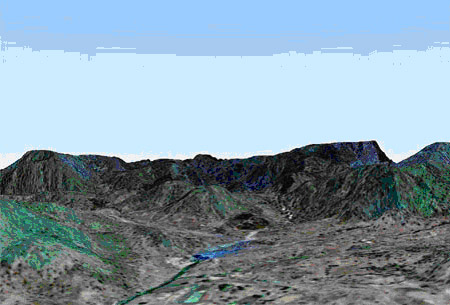
Figure 10 - 3D model of Gujarat state territory, built from Cartosat-1 data
Positions of new space powers, recently considered "third world" countries, in the field of space technologies and products - including space images - are becoming stronger. India has become one of the leading suppliers of Earth remote sensing data to the global market, including to Russia, which no longer has such satellites. Selling high-tech products like Earth images from space brings much-needed currency to India.
India is ready to distribute meter-resolution satellite images obtained with Cartosat-2 below market prices and plans to launch a new spacecraft with a spatial resolution of up to 0.5 meters in the future.
Now the state corporation ANTRIX is preparing for commercial distribution of images worldwide. It should be noted that India no longer intends to sell marketing rights for CARTOSAT-2 data on the global market to the American company GeoEye, and distribution of IRS program data will be carried out according to a direct strategy through its own network of distributors and 15 direct information reception stations. India aims to capture 10-15% of the global market share of the most profitable meter-resolution data segment in the next two years (IKONOS sales in India are about $0.5 million annually). The total annual volume of the global space information market is estimated at $120 million. Today, India is the world's third player (after the USA and France), accounting for up to 25% of global sales [24].
Thus, India's space group includes 6 satellites: IRS-1C/D, IRS-P4, IRS-P6 Resourcesat-1, IRS-P5 Cartosat-1, and Cartosat-2. Another satellite TES with a meter resolution camera is under the control of India's defense department. At a press conference, the director of ISRO announced plans to develop a satellite with an optical camera with half-meter resolution. The new satellite may be launched no earlier than 2010. ISRO laboratories are developing a 1.2-meter aperture telescope, semiconductor detector matrixes, and new materials. India plans to expand its group by launching 4 new satellites Oceansat-2, INSAT-3D, RISAT, and Resourcesat-2 for Earth surface imaging in 2008-2009. Currently, outside India, there are 20 ground stations receiving images from IRS series satellites.
The second largest sector of India's space product and service market is launch services. In April 2007, India already launched the Italian satellite Agile on a commercial basis using the medium-class PSLV rocket and is preparing to enter the market for launching geostationary communication satellites with its heavy GSLV rocket. The launch of two foreign satellites indicates that India is beginning to compete with Russia in the market for launch services for light and medium-class rockets. In 2007, ISRO plans to conduct several more launches, including satellites from Israel, Italy, and Singapore as payloads.
Israel
Israel is rightfully considered one of the world's leading space powers. Since the launch of its first satellite "Ofek-1" in September 1988, Israeli specialists have created dozens of state-of-the-art spacecraft and launched various types of space vehicles. Initially, Israel's space program had a military focus, but over the years, the military component has been complemented by a range of instruments for telecommunications satellites and scientific research stations.
In 1986, the Institute of Space Research was established. The first Israeli satellite "Ofek-1" was launched into orbit by the "Shavit" launch vehicle from a military range in the center of the country. According to foreign sources, the "Shavit" launch vehicle was derived from the Israeli ballistic missile "Jericho-3". With the launch of the "Ofek-1" satellite, Israel became the eighth country in the world to launch its own satellite with its own rocket. Several generations of "Ofek" satellites have since followed. According to reports, the camera equipment installed on the "Ofek-5" satellite allows for space imaging of objects as small as 1 meter at any time of day. Israel plans to launch reconnaissance satellites "Ofek-6" and "Ofek-7", as well as a radar satellite - a new generation of Israeli space technology, surpassing the current "Ofek-5" by 2008 [25].
A milestone in Israel's space program was the creation of the "EROS A" satellite, the world's first lightweight commercial high-resolution observation satellite. On January 18, 2001, ImageSat International received the first images from this satellite. EROS A is used for various commercial applications including geodesy, cartography, urban planning, and fishing.
On April 25, 2006, the Russian conversion rocket "Start-1" successfully placed the Israeli commercial satellite "EROS-B" into the designated orbit. EROS-B was developed by Israel Aircraft Industries (IAI) based on the successful EROS-A model but with unique features. EROS-B is the world's first mini-satellite weighing about 300 kg capable of capturing Earth images with a spatial resolution of up to 0.7 meters from a height of 500 km [25].
As a result of the launch, the Israeli operator ImageSat formed a system in orbit consisting of two high-resolution satellites, EROS-A and EROS-B, capable of competing successfully in the market with leaders such as the American companies DigitalGlobe and GeoEye. The advantages of the orbital system lie in the fact that the working sun-synchronous orbits of the two Israeli satellites are arranged so that EROS-A can take images in the morning and EROS-B in the afternoon. As a result, the probability, frequency, productivity, and informativeness of shooting specific objects are increased. Other competing companies today cannot offer similar services. The disadvantages of Israeli space images related to the absence of spectral imaging channels are offset by affordable prices.
For the distribution of EROS images, an international network of 12 real-time data reception stations has been established in Europe, Asia, Africa, and South America. Since 2004, ImageSat has been supplying EROS-A data to the Russian market. According to a distribution agreement with ScanEx IT Center, since 2005, two Russian stations, UniScan in Moscow and Irkutsk, have been receiving EROS-A images in real-time. During the first year, 350 frames covering major cities of Russia, industrial logging areas in Karelia, Krasnoyarsk Territory, Arkhangelsk and Perm regions, as well as major cities in Ukraine and areas of Kazakhstan, were obtained. It is worth noting that American companies GeoEye and DigitalGlobe are not yet ready to provide real-time images to Russia.
Like American meter-resolution satellites, EROS series satellites are capable of dual-use tasks (defense and socio-economic). Therefore, the Israeli Ministry of Defense plans to purchase EROS images for monitoring objects in the Middle East and Iran (the main source for the Israeli Ministry of Defense remains its own military satellite OFEQ-5 with a half-meter resolution).
According to ImageSat's plans, the third satellite EROS-C with a multispectral optical camera will be launched in 2009. The owner of the EROS series satellite is ImageSat International, formed as a joint venture of Israeli companies Israel Aircraft Industries and El-Op Electro-Optics Industries of Israel with the participation of several European and American investors. The satellite will be placed in a sun-synchronous orbit at an altitude of about 600 km. The equipment installed on the EROS-C satellite will allow imaging of the Earth's surface with a resolution of 0.7 meters in panchromatic mode and 2.8 meters in multispectral mode. The expected operational life of EROS series satellites is at least 10 years.
In addition to its own space program, Israel is widely represented in international space projects. Among joint projects, one can mention the development of video cameras by Israeli companies for experiments in space, the testing of which took place in May 2002 aboard the American shuttle "Columbia", and the creation of the TAUVEX space telescope. As part of Indian-Israeli cooperation in the scientific field, an Indian satellite equipped with an Israeli-made telescope will be launched into space in two years. Scientists from the Hebrew University of Jerusalem participated in the creation of the Japanese precipitation registration satellite "El-Niño". Many Israeli aerospace companies are world leaders. For example, Gilat Satellite Network has become a global leader in the production of satellite terminals. El-Op has developed a television camera for the South Korean observation satellite "Kompsat-2". MABAT offers multi-purpose satellites weighing 500 kg and miniature satellites weighing 50-120 kg for commercial use.
China
China's space program is led by the Academy of Space Technology and primarily serves military and economic purposes. China's space budget is estimated at $1.5 billion annually. China launched its first artificial satellite "China-1" into orbit in April 1970.
China actively uses two spaceports - Xichang and Sichan. Xichang, located 1470 km west of Beijing in the Gobi Desert (41° N and 101° E), is one of China's first spaceports. Sichan Spaceport, located in southwest China (28° N and 102° E), 1300 km from Xichang, specializes in launching CZ-3 launch vehicles, placing payloads into geostationary orbit. The satellite control center for China is located in Weinan (Shaanxi Province). Returning Chinese satellites land in the southern part of Sichuan Province.
In 1999, China launched the CBERS-01 satellite to observe Earth's surface. It was designed to operate for two years but lasted nearly 4 years. In October 2003, it was replaced by CBERS-02. The weight of this satellite is about 1400 kg, and it is on a sun-synchronous orbit at an altitude of 775 km with an inclination of 98.5 degrees to the equator. It is equipped with three cameras with resolutions of 20, 80, and 160 meters. The photos from this satellite are used for agriculture, cartography, and geological purposes by China and Brazil. Since 1998, Brazil and China have been cooperating in the development of satellites for Earth observation. The result of this cooperation has been the CBERS series satellites. The launches were carried out by Chinese rockets. These satellites are used for monitoring river and ocean pollution, deforestation, and urban growth. The total cost of developing and building these satellites was $300 million (30% by Brazil and 70% by China). Now these countries intend to continue their cooperation in this area [26].
Figure 11 – CBERS-01 Satellite
On September 19, 2007, China launched the third Sino-Brazilian satellite CBERS-2B. The satellite was placed in a morning sun-synchronous orbit at an altitude of 748x769 km with an inclination of 98.54 degrees and a crossing time of the equator at 10:30.
According to the project, the satellite will perform its tasks for 2 years. Its weight is 1452 kg. The satellite is capable of timely transmitting photos and data to China, Brazil, and other client countries regarding agriculture, environmental protection monitoring, urban planning, and land and natural resource reconnaissance.
The satellite is equipped with three multispectral OES: HRCC scanner with a resolution of 20 m over a swath of 113 km, IRMSS OES 80 m and 160 m over a swath of 120 km, and WFI scanner - 260 m over a swath of 885 m.
In order to gain a place in the global geoinformatics market, China has chosen a rather unusual approach: CBERS-02B satellite images will be transmitted in open mode for free. The message does not specify which specific scanner information will be transmitted in open mode. Perhaps the Chinese will retain the rights to sell data from the high-resolution scanner or license the software.
Today, China has created an impressive constellation of 10 satellites in orbit for collecting spatial information and Earth observation. This includes two meteorological satellites FY-1D and FY-2C, ocean observation satellite HY-1A, Sino-Brazilian Earth resources satellite CBERS-02, three Resource-2 (ZY-2) series Earth resources satellites, small satellites "Beijing-1" and "Tsinghua-1", and Experimental. In addition, China has launched 22 dual-purpose FSW series satellites equipped with Earth observation cameras that return data. The main Chinese data reception station for Earth resources satellites is located near Beijing, gathering data not only from Chinese satellites but also from 9 spacecraft of leading international Earth observation programs from the USA, Europe, Canada, France, and India.
During the 11th Five-Year Plan (2006-2010), China plans to establish a system of 8 low-orbit small Earth resources satellites of the HJ series equipped with optical and radar equipment. Within the next 1-2 years, China will launch two mini-satellites HJ-1A/1B with optical telescopes and one satellite HJ-1C with radar, alongside creating ground infrastructure for data collection and processing. According to a representative from MOST, China has approved a program to develop high-resolution optical satellites comparable to the "Ikonos" class. In 2007, China also plans to launch the HY-1B ocean multi-spectral observation satellite, FY polar meteorological satellite, and the third Sino-Brazilian CBERS-02B Earth observation satellite equipped with three optical-electronic scanners with high, medium, and low spatial resolutions (20 m, 80 m, and 260 m). China plans to launch a total of 18 Earth observation satellites over the next decade.
China has also achieved success in satellite navigation. The country has established the regional navigation system based on 3 geostationary satellites "Beidou-1" (BD-1), which is applied in transportation, fisheries, maritime navigation, and mineral resource development. It has been reported that China is developing a multi-satellite constellation project for a new navigation system "Compass-2". Currently, international radio frequency coordination is underway within the ITU. China is also a partner in the development of the European navigation system "Galileo". The new Earth observation and navigation systems (EOS) of China are designed to enhance the quality and competitiveness of national space systems, integrate the mechanism of space information usage into the practical activities of state structures, and integrate national and foreign systems into a unified Earth observation and navigation complex (GPS/GLONASS/Galileo/Compass).
Over the past 20 years, the Chinese government has developed one of the world's largest markets for commercial satellite images. It has achieved full autonomy in medium-resolution images and aims to achieve the same for sub-meter resolution images within the next three to five years, according to the China Center for Resource Satellite Data and Applications (CRESDA).
Korea
The government of the Republic of Korea has a high technology support program, including aerospace technologies, which it considers the best way to enhance the country's competitiveness in the international market. The Korean Aerospace Research Institute KARI was established in October 1989 for research and development in aerospace technologies.
Over the past 15 years, South Korea has launched 9 artificial Earth satellites for observing the Earth's surface and oceans, as well as for military purposes. Additionally, South Korea uses its satellites for commercial communication.
The first Korean multipurpose satellite KompSat-1 provided a resolution of 6.6 m with a swath width of 17 km. The second Korean multipurpose satellite KompSat-2 was launched on July 28, 2006, using the "Rokot" carrier rocket from the Plesetsk Cosmodrome (Russia). The satellite was developed by engineers from KARI in collaboration with the EADS Astrium consortium. Exclusive rights for data supply from the KompSat-2 satellite were obtained by SPOT Image (France). The satellite was placed in a sun-synchronous orbit at an altitude of 685 km. KompSat-2 is designed for obtaining digital images of the Earth's surface with a spatial resolution of 1 m in panchromatic mode and 4 m in multispectral mode. The calculated swath width is 15 km. High-detail space information will be used for cartography, environmental monitoring, mineral resource exploration, and defense purposes [27].
From this satellite, it is possible to obtain 7,500 images daily with a coverage of 15x15 km, providing a total coverage of 1.7 million sq. km. Such images are suitable for mapping at scales of 1:5000 to 1:2000. The Korean Aerospace Agency (KARI) is currently working on new satellites in the KompSat series and the COMS-1 satellite for telecommunications, meteorology, and oceanography. Over the next 10 years, KARI plans to launch another 10 satellites for various purposes.
According to the national space agency, South Korea plans to launch a new dual-purpose Earth observation satellite around 2012. The satellite, named Arirang 3A, will be an upgraded version of the Arirang 3 satellite, scheduled for launch in 2009. Like its predecessor Arirang 3, the new satellite will be equipped with a multispectral sensor MSC with a resolution of 70 cm. Additionally, it will include multiple infrared channels for firefighting, monitoring heat sources in cities, observing volcanic activity, and tracking ground vehicles, ships, and aircraft movements.
The cost of developing Arirang 3A is estimated at $228.2 million. The infrared sensor will be developed by Korean specialists by 2009. Arirang 3A is planned to be placed in orbit at an altitude of 450-890 km. The swath width will be 16.8 km, and its operational lifetime is expected to be 4 years.
South Korea also plans to launch the Arirang 5 radar imaging satellite (KOMPSAT-5) into orbit in 2008 and enter the radar imaging data market. European company Alcatel Alenia Space will develop and launch the KOMPSAT-5 satellite for Korea by the end of 2008 with onboard SAR. The message does not provide the satellite's characteristics, but based on recent scientific publications, the KOMPSAT-5 satellite will be equipped with an X-band radar with spatial resolution of several meters.
South Korea will spend 3.8 trillion won ($4 billion) over the next 10 years on satellite and rocket technology research, according to Chung Hae-yan, representing South Korea's Ministry of Science and Technology. "Space research is an investment in the future," he emphasized. Chung Hae-yan added that space research will also help South Korea in finding necessary resources for its economy.
Canada
In 1990, Canada established the Canadian Space Agency, which oversees aerospace activities.
On November 4, 1995, the Canadian commercial satellite RADARSAT-1 began operating in orbit. RADARSAT-1 became the world's first commercial satellite with a synthetic aperture radar, which ensured its high (up to 8 m) spatial resolution and sustained demand for its data. Radar allows imaging independent of weather conditions and at any time of day, crucial for satellite remote sensing systems. Additionally, customers can request emergency imaging of a specific area with a response time of just 29 hours, receiving real-time data.
Originally designed for a 5-year mission lifespan, RADARSAT-1 doubled its operational period, continuing to deliver high-quality images. Over 10 years of flawless operation, RADARSAT-1 mapped a total area of 58 billion square kilometers, which is two orders of magnitude larger than Earth's surface area. The system's reliability reached 96%. The largest of RADARSAT-1's 600 data consumers is Canada's ice reconnaissance service, receiving 3800 radar images annually with a latency of less than 90 minutes after imaging.
For commercial distribution of RADARSAT-1 data worldwide, an international network was established comprising 28 direct reception stations for RADARSAT-1 data and 80 distributor companies. The only Russian reception station in this network, operated by ScanEx, covers almost the entire territory of the European part of Russia and neighboring states, the Arctic Ocean, the Caspian, Black, and Azov Seas [28].
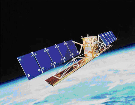
Figure 12 - RADARSAT in space as depicted by an artist
The Canadian Space Agency signed a contract with MacDonald, Dettwiler and Associates (MDA) to develop the second-generation satellites for Earth observation using the Radarsat-2 radar. Radarsat-2 provides images with a resolution of 3 meters per pixel.
The third-generation satellite project Radarsat 3 plans to place it into a polar orbit, where it will conduct radar imaging of the entire Earth's surface for 7 years, focusing primarily on polar regions. Radarsat-3 will be launched 2-3 years after Radarsat-2, and these two satellites will operate in tandem. Their observations will be used for both commercial and non-commercial purposes such as natural resource exploration, civil engineering, land use planning, navigation, flight path planning, flood monitoring, etc.
Australia
Australia began its space activities in the 1960s when it established the powerful Woomera launch complex in the desert near Adelaide in southern Australia. In the 1960s-1970s, it launched sounding rockets and American and British launch vehicles from this site. In 1967, Australia launched its first satellite, WRESAT, from the Woomera test range, followed by the Australian research satellite Prospero in 1971.
Economically beneficial space activities for Australia include telecommunications, navigation, Earth remote sensing, and scientific research, primarily for meteorology and environmental protection needs.
As part of the commercial global geological monitoring and mapping project, Australia will launch its Earth remote sensing satellite (ERS) Aries-1. This satellite is planned to be equipped with a highly sensitive spectrometer operating in 105 visible, near-infrared, and shortwave infrared bands. At a working orbit altitude of 450-500 km, a typical frame will cover an area of 15x15 km with a ground resolution of 30x30 m. The tilted observation optical system will allow viewing any Earth region every 6-7 days. The 450-480 kg Aries-1 satellite is planned for deployment into a low Earth orbit at an altitude of 500 km. The manufacturing cost of the Aries-1 satellite is estimated at $72 million.
The Aries-1 satellite will provide data on mineral deposits in rocks and soils, including through moderate vegetation cover. It will also monitor forests and coastal areas, control various environmental parameters globally, and support long-term weather forecasting and crop size estimation based on satellite data.
Australia actively collaborates with several countries in space exploration. Australian companies are also involved in developing a microsatellite jointly with South Korea for environmental data collection in rural areas of the Asia-Pacific region. According to CRCSS, the project's cost is estimated at $20-30 million. Cooperation with Russia holds significant prospects.
Other Countries
Since 1988, South Africa has been conducting research and space utilization under its national program at the Overberg test range, located 170 km from Cape Town. In the late 1980s, the first ballistic rockets were launched from this range.
Russia intends to assist South Africa in creating a national Earth remote sensing satellite system (ERS). Later this year, a Russian rocket will commercially launch a South African satellite that will conduct scientific observations. Russia also sees bilateral space cooperation in using South Africa's ground infrastructure, which has been modernized since the 1950s.
Overall, according to the deputy head of Roscosmos, although bilateral space cooperation "is not yet at the appropriate level, the prospects here are very good - contacts and negotiations are ongoing, and South Africa's scientific base is quite high." According to him, this country actively participates in international Earth observation communities; in particular, the next meeting of the "Global Earth Observation Systems" society will be held in Cape Town in the fall of 2007. In the direction of space industry development, "South Africa is moving progressively and purposefully, they have great potential, hence great potential for cooperation with Russia," concluded the deputy head of Roscosmos.
Brazil is negotiating with several countries (including Russia) to establish an international commercial spaceport near Alcantara (2° 17' S and 44° 23' W).
On July 6, 1988, an intergovernmental protocol was signed, followed by an inter-agency agreement in 1989, under which the China Academy of Space Technology (CAST) and the Brazilian National Institute for Space Research (INPE) began developing the China-Brazil Earth Resources Satellite (CBERS). The development cost approximately $300 million, with China contributing about $200 million and Brazil $100 million. Brazilian specialists developed the satellite structure, power system, onboard computer, WFI instrument, and SCD data collection system. China undertook the satellite's launch, with Brazil promising to reimburse 30% of the costs.
Participation in the project allowed Brazil to gain access to and accumulate experience in space technologies, develop its scientific and technical potential, and create a production structure for future (including international) projects. Based on CBERS development experience, Brazil intends to develop its own communication and meteorological satellites. Finally, the project strengthened ties between the two countries, placing Brazil among the leaders in the "third world."
The CBERS-1 satellite is designed to monitor natural resources in China and Brazil for agricultural, geological, hydrological, geographical, cartographical, ecological, oceanographic, and other disciplines. Based on CBERS data, urban planning, land use analysis, environmental pollution monitoring, water purity, forest monitoring, deforestation, and fire-related losses, as well as natural phenomena (droughts, floods, etc.), can be conducted. The information obtained from the satellite will enable long-term weather forecasting and estimation of future harvest sizes.
Subsequently, additional agreements were signed for the manufacture and testing of CBERS-2 in Brazil and for INPE's participation in managing the CBERS system. On September 19, 2007, China launched the third China-Brazil Earth Resources Satellite CBERS-2B. The satellite was placed in a morning sun-synchronous orbit with dimensions of 748x769 km and an inclination of 98.54 degrees, crossing the equator at 10:30. According to the project, the satellite will fulfill its tasks for 2 years. Its weight is 1452 kg. The satellite is capable of timely transmitting photos and data to China, Brazil, and other customer countries related to agriculture, environmental protection monitoring, urban planning, and reconnaissance of land and natural resources.
Taiwan has announced plans to develop its own satellite constellation, the form of which is yet to be determined. Taiwan is now considering its options for this project, evaluating the feasibility and advantages of each of them.
Recently, Taiwan's National Space Organization (NSPO) announced plans to develop its first satellite entirely by national industry efforts. The project, named Argo, aims to create a small Earth observation satellite (EOS) equipped with high-resolution optical instruments.
Previously, Taiwan's space agency funded three projects under the Rocsat series, later renamed Formosat-1, -2, and -3. Formosat-1, launched in 1999 aboard the American Athena-1 rocket, was developed by the U.S. company TRW with partial involvement from Taiwanese companies. It was used for multispectral ocean imaging and technological experiments.
The second satellite, Formosat-2, costing $142 million, was built by the French company Astrium SAS, assembled in Taiwan, and launched into orbit by the American Taurus rocket in 2004. Weighing 740 kg, it features a high-detail optical camera RSI for Earth imaging with spatial resolutions of 2 and 8 meters in panchromatic and multispectral modes. Marketing rights for Formosat-2 images on the global market were acquired by the French company SPOT Image, which established a network of receiving stations [29].
The international Formosat-3/COSMIC (Constellation Observing System for Meteorology, Ionosphere and Climate) program, costing $100 million, involves launching six microsatellites developed by Taiwanese and U.S. enterprises for atmospheric and ionospheric research, weather and climate prediction. The launch of the Formosat-3 satellite is scheduled for late March 2006 from Vandenberg Air Force Base (California) using a Minotaur rocket.
Recently, NSPO announced the start of the Argo project aimed at creating a mini EOS satellite weighing 200 kg and costing $47 million, developed entirely by national industry. The satellite's onboard optical-electronic equipment will provide multispectral imaging with a spatial resolution of 6.5 meters over a swath of 77 km. The mini-satellite is planned to be launched into a 660 km orbit by late 2008 or early 2009 using the commercial Falcon-1 rocket and will join the multi-satellite international system RapidEye, being the Taiwanese segment (also known as RapidEye-6).
According to NSPO, the Argo project has already developed a space platform featuring a new LEON-3 processor in its control system. All onboard software and ground flight control center systems are planned to be developed in Taiwan. The estimated operational lifespan of the satellite is 7 years.
With full deployment, the RapidEye system of 6 satellites will provide daily imaging of any Earth region under favorable meteorological conditions. The main applications of the RapidEye system include land use monitoring, ecological and environmental monitoring, agriculture and forestry, disaster management, and cartography. Major users of satellite data will include agricultural complexes, insurance, engineering and construction companies, environmental organizations, and other agencies.
According to NSPO estimates, the Argo project is expected to be a significant milestone in Taiwan's industrial development with potential future export contracts for EOS satellite development based on advanced small satellite platforms.
Egypt, Thailand, Vietnam, Indonesia, Malaysia are striving to join the club of countries operating EOS and have planned satellite launches. Plans for EOS satellite launches are also underway in Singapore, Turkey, Egypt, Saudi Arabia, Iran, Algeria, Argentina, and Nigeria.
CIS Space Programs
Belarus
Belarus' space program is carried out under the joint program "Development and Use of Advanced Space Systems and Technologies for the Economic and Scientific-Technical Development of the Union State" for the period 2004-2007. Funding for the joint program is provided by the own funds of enterprises and organizations of the Russian Federation and the Republic of Belarus participating in the program.
The first Earth remote sensing satellite "BelKA" was intended for regular and prompt imaging of Earth surface areas in the visible and near-infrared spectral ranges with high spatial resolution, storage, and transmission of received target information to ground-based receiving points of the EOS. The "BelKA" satellite was developed by RKK "Energia", with its payload, including optical-electronic equipment, manufactured in Belarus.
The satellite, costing about $10 million, was planned to be placed into a sun-synchronous orbit at an altitude of 510 km. The information obtained from the satellite was intended for use in agriculture, forestry, water management for disaster prevention and forecasting, natural resource protection, and urban planning.
As a result of the accident of the Dnepr carrier rocket on July 26 at the Baikonur Cosmodrome, 18 spacecraft were lost, including Belarus' first satellite "BelKA".
On July 22, 2012, the launch of the Canopus-V No. 1 satellite and the Belarusian Space Apparatus (BSA) was successfully completed, which operate in a unified orbital grouping. The development and creation of these spacecraft were carried out by enterprises of FSUE "NPP VNIIEM" and the Institute of Geoinformation Systems of the National Academy of Sciences of Belarus under orders from the Russian Ministry of Emergency Situations, Roshydromet, Ministry of Natural Resources of Russia, Russian Academy of Sciences, and the National Academy of Sciences of Belarus.
Both spacecraft have a similar appearance, characteristics, are equipped with the same imaging equipment, and are located in a sun-synchronous orbit with a 180-degree separation from each other. They were designed to operate in tandem.
Space activities in Japan are managed and coordinated by an advisory body to the Prime Minister — the National Space Development Agency (NASDA).
In order to expand the space research program and reduce foreign dependency, NASDA proposed a sharp increase in appropriations. In 2000, they were approximately $40 billion annually (for comparison, by that time NASA had expenditures up to $26.6 billion, and ESA up to $8.66 billion).
The main feature of Japan's space program is its broad thematic scope at minimal cost. Despite all its achievements in space, Japan spends ten times less than NASA. To implement national space programs, Japan has established and equipped with modern technological and test equipment two spaceports: Uchinoura and Tanegashima, and several research centers.
In 1998, Japan deployed the Intelligence Gathering System (IGS) in a standard four-satellite configuration in orbit. The national IGS system, second in the world in number after the United States, became an important source of independent objective visual information about the situation in North Korea and other countries.
Japan's decision to create the IGS system was made after the launch of a North Korean ballistic missile over the Japanese islands in August 1998. After the successful launch on March 28, 2003, of the first pair of IGS-O1 and IGS-R1 satellites (optical and radar), an accident occurred. The third satellite with an optical telescope, IGS-O2, was successfully launched into orbit on September 11, 2006. With the launch of IGS-R2, the IGS system finally reached its full complement [21].
The expansion of the system to four satellites significantly improved its capabilities for collecting visual information. The system can observe any region of the Earth within a day, with higher frequency of observation for regions in the Far East. The average revisit period for the IGS-R radar satellite pair is less than 24 hours, if Japanese satellite radars provide coverage on both sides of the flight path (similar to the US system, the Joint Global Multi-Satellite Imaging System). Observations made by the IGS-O optical satellites can be conducted without interruption, regardless of the time of day or meteorological conditions. The system for processing and analyzing images obtained by IGS will be placed in a newly built center in Kasumigaura, Japan.
The launch of the fourth satellite of the series, IGS-O3, is expected no earlier than 2009.
Research on soil properties and functions from space is another focus of Japan's work. They are conducted under the ALOS (Advanced Land Observing Satellite) program. It carries two multipurpose ultra-high resolution radio sensors (AVNIR-2) and Panchromatic Imaging. The program has begun releasing vehicles as planned under the program. In mid-2006, Japan launched its own satellite into orbit. It is expected to be able to study certain elements of the Earth for years as part of the space service. Based on the satellites of this program, satellites can be downloaded, providing research, learning zones.
The international AMOS configuration satellite was orbited by israel during using for the purposes 2009.
Table 1. Main Characteristics of the "Kanopus-V" and BSA Satellites
| Satellite Dimensions, m×m | 0.9×0.75 |
| Satellite Mass | 450 kg |
| Payload Mass, kg | 110 |
|
Orbit: altitude, km inclination, degrees orbital period, min equator crossing time, hour |
Sun-synchronous morning 510 98 94.74 10:30 – 11:00 |
| Platform: tilt angles (pitch and roll), degrees orientation accuracy, arcmin stabilization accuracy, degrees/sec |
from -40° to 40° 5 0.001 |
| Revisit period, days | 15 |
| Average daily power consumption, W | 300 |
| Operational lifespan, years | 5-7 |
The "Kanopus-V" and BSA satellites are designed to address the following tasks:
- monitoring emergency situations;
- mapping;
- detecting forest fire outbreaks and pollutant emissions;
- recording abnormal physical phenomena for studying and predicting earthquakes;
- monitoring water resources and agriculture;
- land use management tasks;
- highly operational surveillance.
The creation of such an international constellation of Russian-Belarusian satellites like "Kanopus-V" and BSA with unique properties for operational and various types of imaging capabilities will significantly expand the application scope of Russian-Belarusian data in the global remote sensing market.
Ukraine
The recognition by the European Union of Ukraine's role in shaping the new architecture of European security can and should be used as a significant lever to promote Ukrainian interests in relations with the EU, ensuring the most effective use of the export potential of Ukraine's military-industrial complex. Such steps will contribute to strengthening Ukraine's security by ensuring economic and political stability in the pan-European space.
In the current situation, there is an opportunity to provide Ukrainian industrial enterprises with orders from European countries. The adoption of such measures will help prevent crisis phenomena in Ukraine, enhancing its political and economic impact on pan-European integration processes.
The national space program of Ukraine pays significant attention to Earth observation. In 1995, the first Ukrainian satellite "Sich-1" was launched, and in 1999, the Ukrainian-Russian satellite "Ocean-O" was launched for comprehensive observations in the visible, infrared, and microwave ranges of the spectrum. Both satellites continue to function for their intended purpose. Ground infrastructure has been created for satellite management, reception, and preliminary processing of Earth observation data. It is planned to launch a modernized satellite "Sich-1M" with a high-resolution optical scanner (~ 30 m) and a multi-band (visible, infrared, microwave) survey observation system; the design of optical and radar observation space systems with resolutions of 1 - 8 m is underway, with their commissioning planned for 2007.
Nevertheless, the current main problem in the development of remote sensing remains the low commercial return of space assets, which is typical, without exception, for all modern space systems. Despite the low cost of imaging per unit area and the enormous volumes of data collected, the share of space information in the total volume of thematic products for consumers remains quite low - up to 10-15%.
Experience with the "Sich-1M" and "Ocean-O" systems has shown that insufficient attention has been paid to promoting remote sensing services on the national and international markets: the network of receiving stations was limited to the territories of Ukraine and Russia, there is no distribution network for disseminating remote sensing data and processing it into a ready-made information product for the user. Therefore, to successfully solve a wide range of operational applied tasks, a fundamental restructuring of the technology for planning imaging, obtaining, and delivering information is necessary.
The first Ukrainian satellites "Sich-1" and "Ocean-O" were created and operated in close cooperation with the Russian Federation. In the future, it is necessary to develop and expand integration ties with other interested countries.
In this regard, the creation of the Ukrainian-Russian space system "Sich-1M", aimed at integrating into the global satellite Earth observation network, is indicative. The selected set of research equipment meets the modern world level of remote sensing development and allows solving a number of practical tasks for both observing terrestrial vegetation and soil cover and studying the World Ocean and atmosphere, as well as monitoring hydrological and ice conditions.
Thus, the satellite is equipped with a set of low-resolution equipment (optical - MSU-M and radar - RLS BO), operating in a combined frame mode and providing global all-weather monitoring of sea and continental ice, surface wind, atmospheric fronts, large oil spills, and more.
As for high-resolution space systems better than 10 meters, their creation is also advisable to be conducted in cooperation with interested foreign partners and owners of similar systems. When creating prospective satellites, special attention should be paid to enhancing the information capabilities of the system. In this regard, Ukraine has a number of original developments.
For the effective operation of the space segment in the interests of users, a key condition is the creation of ground infrastructure, ensuring regular reception of information from national and foreign satellites, its processing, and delivery to users as a finished product.
Currently, at Yuzhnoye Design Bureau, the next stage of the remote sensing system - the "Sich-1M" satellite - is being developed, based on the structural platform of the "Sich-1" satellite, but with an improved scanner providing significantly better resolution. The parameters of the side-view radar will also be improved. The satellite will be equipped with an optical-microwave scanner MTV3A-OK for simultaneous measurements in the infrared and microwave ranges, providing global environmental monitoring for meteorology and oceanology, as well as solving industrial tasks. A qualitatively new ground complex for receiving, processing, and distributing Earth observation information will also be introduced. For the first time in Ukraine, its composition will include an operator center, which, in addition to coordinating the system's work, will address commercialization tasks. Projects for the distant future - meter-resolution satellites in optical and radar ranges "Sich-2" and "Sich-3" - are also being developed at Yuzhnoye Design Bureau.
Previously, funding for rocket and space activities was carried out on a residual principle, amounting to up to 90 million UAH annually. The Law of Ukraine "On the Nationwide (National) Space Program" provided for funding averaging up to 360 million UAH per year. The Concept considers several options for financing space activities - up to 250 million UAH annually. However, to optimally develop the sector, the total amount of budget support should be 750-900 million UAH. Additionally, extra-program funds of at least 50% of the specified amount should be attracted.
In 2001, the Ukrainian Yuzhnoye Design Bureau (Dnipro) won an international tender held by the Egyptian government to create the first Egyptian remote sensing satellite EgyptSat-1. Apart from Ukraine, the tender included participants from the UK, Russia, Korea, and Italy. Created based on microtechnology, the EgyptSat-1 weighing up to 100 kg will be operated in a sun-synchronous orbit. The reason for the delay in launching the Dnepr launch vehicle with 16 foreign microsatellites, including the first Egyptian remote sensing satellite (RSS) EgyptSat-1, was a malfunction in the cable network of the rocket's booster stage.
According to the head of the NSAU, the EgyptSat-1 built by Ukraine should be launched in 2007. Within three years, the Ukrainian side will also ensure the creation and deployment of a ground control station in Egypt and the modernization of the remote sensing data receiving station, as well as training Egyptian personnel and preparing local specialists to develop satellites of this class. According to the GIS-Association, the director-general of the National Space Agency of Ukraine (NSAU), Yuri Alekseev, does not rule out that Ukraine will build another, second, remote sensing satellite for Egypt — EgyptSat-2, as well as the Algerian RSS satellite Alsat-2.
Kazakhstan
The success of Kazakhstan's satellite projects, implemented mainly with the support of Russian space structures, largely depends on their alignment with consumer expectations.
Today, as the space industry has emerged as one of the priority and high-tech sectors, Kazakhstan, no longer content with the position of a landlord, can and should become an active participant in the international space market. In 2004, a state program for the development of space activities in the Republic of Kazakhstan for 2005-2007 was adopted, aiming to strengthen national and information security, promote socio-economic and scientific-technical development of the country through the effective use of space technologies. Currently, the national company Kazcosmos is developing the concept of a space industry development program for the period up to 2020, and presumably, the document will be submitted for public discussion in 2007 [36].
Representatives of scientific research organizations and production-implementation structures of Kazakhstan, Russia, and foreign countries involved in the implementation of Kazakhstan's space program believe that the priority direction of space activities development in Kazakhstan should be satellite communication systems and remote sensing systems.
In the spring of 2006, the first domestic communication satellite of the republic KazSat was launched from the Baikonur cosmodrome, which Russia has leased from Kazakhstan since 1994. Currently, Kazakhstan, with the help of the Russian side, is preparing to launch a whole group of communication satellites.
Another direction for the development of satellite systems — remote sensing of the Earth (RSS) from space, according to market participants, is particularly relevant for the country given its territorial characteristics, which include vast territory and low population density. Effective management of such infrastructure and its control is impossible without space monitoring systems. The tasks of RSS systems lie in the fields of defense and security, the search for minerals and energy resources, agriculture and forestry, emergency monitoring, land use, and environmental control.
Experts note that the creation of national RSS satellites is one of the most characteristic trends in the space industry. National RSS systems are operational and being developed in India, China, Israel, Thailand, Korea, Argentina, as well as in many other countries, including the post-Soviet Ukraine and Belarus. Kazakhstan does not yet have its own RSS satellites, but the country has a system for receiving and processing RSS data from Indian, US, Russian, and Canadian satellites. Involved in this work are the Institute of Space Research with receiving stations in Astana and Almaty, as well as the company "Kazgeokosmos," which has a receiving station in Atyrau.
Using space-based remote sensing means, it is possible to monitor the state of infrastructure, agricultural activities, and emergencies, accurately assess the consequences of accidents and natural disasters. Therefore, the prospects for developing observation satellite systems should be evaluated not only at the state level but also at the level of banking structures, large and medium-sized corporate users who will consume the new service, derive profit from it, and invest it in the satellite industry, reproducing it at a higher technological level.
Russian Space Program
Main Provisions of the Federal Space Program of Russia for 2006-2015
Russia's space activities are carried out in accordance with the Federal Law "On Space Activities," enacted by the resolution of the Supreme Council of the Russian Federation on August 20, 1993, N 5664-1, with clarifications and amendments made by Federal Laws from November 29, 1996, N 147-FZ, January 10, 2003, N 15-FZ, March 5, 2004, N 8-FZ, August 22, 2004, N 122-FZ, and February 2, 2006, N 19-FZ. The law regulates the principles, goals and objectives, organization and management, and economic indicators of space activities. The priority areas of space activities are defined by the "Fundamentals of the Policy of the Russian Federation in the Field of Space Activities for the Period up to 2010," approved by the President of the Russian Federation on February 6, 2001, and the Concept of National Space Policy, approved by the resolution of the Government of the Russian Federation on May 1, 1996, N 533.
The implementation of the "Fundamentals of the Policy of the Russian Federation..." is carried out by the Russian Space Agency through the execution of tasks defined by the Federal Space Program of Russia for 2006-2015 (FCP-2015) and the federal target program "Global Navigation System" (FTP “GLONASS”), approved by the resolutions of the Government of the Russian Federation on October 22, 2005, N 635, and August 20, 2001, N 587, respectively [30].
The goal of the FCP-2015 is to meet the growing needs of state structures, regions, and the country's population in space means and services based on:
- increasing the efficiency of using outer space to address the tasks facing the Russian Federation in economic, social, scientific, cultural, and other fields of activity, as well as in the interests of the country's security;
- expanding international cooperation in space activities and fulfilling the international obligations of the Russian Federation in this area, developing, applying, and supplying rocket and space technology;
- strengthening and developing the space potential of the Russian Federation, ensuring the creation and use of the required range of space systems and complexes with characteristics that meet the global level of space technology development, as well as guaranteed access and necessary presence in outer space.
The main tasks of the Program are:
- developing, replenishing, and maintaining the orbital grouping of spacecraft in the interests of the socio-economic sphere, science, and the country's security (communication, television broadcasting, relay, remote sensing of the Earth, hydrometeorology, environmental monitoring, emergency control, fundamental space research, space microgravity research);
- creating, deploying, and operating elements of the Russian segment of the International Space Station to conduct fundamental and applied research, implementing a long-term program of scientific and applied research and experiments planned for the Russian segment of the International Space Station;
- ensuring the functioning of the Russian segment of the international satellite search and rescue system COSPAS-SARSAT;
- creating promising means of launching spacecraft;
- maintaining and developing the facilities of the Baikonur cosmodrome;
- ensuring the creation of rocket and space technology products with world-level characteristics.
The implementation periods and stages of the Program are 2006-2015.
At the first stage (up to 2010), the following are being created in terms of remote sensing of the Earth:
- a space meteorological monitoring system consisting of 5 spacecraft;
- a space environmental monitoring system consisting of 4 spacecraft.
At the second stage (up to 2015), the build-up and maintenance of orbital groupings are ensured:
- the space meteorological monitoring system consisting of 3 fourth-generation and 2 third-generation spacecraft;
- the space environmental monitoring system consisting of 5 spacecraft.
The most important areas of space activities of the Russian Federation are defined by the Fundamentals of the Policy of the Russian Federation in the Field of Space Activities for the Period up to 2010 and the Fundamentals of the Military-Technical Policy of the Russian Federation for the Period up to 2015 and Beyond, approved by the President of the Russian Federation on February 6, 2001, and March 11, 2003, respectively.
The priority areas of space activities that contribute to achieving strategic goals are:
- monitoring the environment and near-Earth space, controlling emergency situations and environmental disasters, researching Earth's natural resources;
- providing federal executive authorities, executive authorities of the subjects of the Russian Federation, and local self-government bodies with geophysical, including hydrometeorological, information.
To control emergency situations and solve the most urgent natural resource tasks, it is necessary to ensure by 2010 the observation of the Earth's surface with a total area of 20-30 million square kilometers (the territories of Russia and adjacent zones of economic interests). In this case, individual regions should be observed with a frequency of 3 hours to 1 day and a resolution of 1-5 meters. Considering the commercial and economic interests of the Russian Federation, by 2015, the total observed area should increase to 50-70 million square kilometers, with a resolution of 1-5 meters and a frequency for individual regions from real-time to 1 day. The task of predicting man-made and natural emergency situations will become particularly important. Space means should ensure continuous environmental monitoring of the territory of the Russian Federation, as well as control over the state of especially important objects.
The basis of space activities is Russian space means, the creation and development of which accelerate the process of economic formation, ensure the effective development of science, technology, and the social sphere, and strengthen the country's defense capabilities. If state needs for space means and services are not met through the creation and development of Russian space means, they will be satisfied by acquiring services on the world market, which will require significant economic costs, significantly reduce the opportunities for the innovative development of the domestic economy, and increase the gap between the Russian Federation and the most developed countries in the post-industrial society.
However, due to the negative economic conditions that developed at the end of the 20th century, the further development of Russian space means is associated with resolving the following problematic situation. The Russian orbital grouping of spacecraft for socio-economic and scientific purposes, except for communication and broadcasting, lags in its development from the level required for fully addressing the tasks in the interests of the socio-economic sphere, science, and international cooperation.
Orbital means of remote sensing of the Earth are practically absent in Russia at present, which sharply limits the possibilities of solving natural resource use, hydrometeorology, and emergency prediction tasks using modern methods and to the required extent.
Russian spacecraft of previous designs do not have the required characteristics in terms of active lifespan, capabilities of target equipment, throughput capacity, and data transmission speed of information channels, as well as the ability to autonomously process information on board spacecraft. The composition and quality indicators of ground equipment for users lag behind the requirements of the time.
Space technology and space technologies in 2006 - 2015 should develop based on the wide use of information technologies and nanotechnologies. This will require a modern equipment park involved in the technological cycle and capable of implementing the latest technologies. In this regard, the tasks of technical re-equipment, the introduction of new high-tech technologies, the improvement of qualifications, and the rejuvenation of scientific and technical personnel come to the forefront.
The ground space infrastructure, including spaceports, ground control facilities, information reception points, and an experimental base for ground testing of rocket and space technology products, needs modernization and re-equipment with new equipment.
The current state of Russian space assets leads to an increasing lag of the Russian Federation in space activities from the leading space powers of the world and does not allow meeting the country's needs with Russian means.
If adequate measures are not taken, this process will become irreversible and will turn into a brake on the accelerated development of the country's technical and economic potential.
The program activities include activities funded by budget funds and activities carried out by funds invested in space activities by non-state customers.
Activities funded by budget funds include works provided in the following sections:
- Section I – "Research and Development";
- Section II – "Procurement of serial space equipment to maintain the functioning of the space vehicle constellation in the required composition, ensuring the performance of research and development work, as well as for the management of space vehicles accepted for operation";
- Section III – "Maintenance of ground space infrastructure objects";
- Section IV – "State capital investments for the reconstruction, technical re-equipment of industrial enterprises, and development of ground space infrastructure objects".
Within Section I, it is planned to carry out activities in 11 subsections.
The subsection "Earth remote sensing, hydrometeorological observation, environmental monitoring, and emergency control" provides for the creation of:
- Geostationary and low-orbit space complexes and systems of the new generation for hydrometeorological support and operational monitoring of earthquakes, man-made, and natural emergencies;
- Optical-electronic space complex for the study of the Earth's natural resources and a space system based on it;
- Space radar observation system, as well as an integrated satellite system for Earth remote sensing;
- Advanced multifunctional complex and centers of ground reception, registration, and processing of remote sensing space information;
- Validation subsatellite observation complexes, data banks, and technologies for the dissemination of space information;
- Onboard instruments for Earth remote sensing satellites.
Activities carried out by funds invested in space activities by non-state customers include works in the following areas:
- Space communication, broadcasting, and relay systems;
- Earth remote sensing, hydrometeorological observation, environmental monitoring, and emergency control;
- Space vehicle launch systems;
- Spaceport objects and ground experimental base.
The results of these works are planned to be used to solve tasks for state needs.
Upon the implementation of the Program, the following results will be achieved:
1) The development, modernization, and commissioning of new-generation space systems and complexes will be completed, including:
a) The capacity of trunk, intrazonal, local, corporate, and departmental communication networks will be increased, and the capacities of distribution broadcasting networks will be increased, ensuring in the necessary volumes and with the specified quality:
- Global, real-time, stable, and absolutely secure presidential and government communications;
- The needs of federal executive authorities, executive authorities of the constituent entities of the Russian Federation, and local self-government bodies in modern telecommunications, including confidential communications;
- The needs of residents of all regions of Russia, including sparsely populated and remote areas, in modern types of communications;
The needs of land, sea, and air subscribers in global communications using compact terminals for mass consumers that meet modern requirements in terms of types, quality, and volume of services, taking into account international standards;
b) The frequency of updating hydrometeorological observation data will be increased to 3 hours for medium-altitude space vehicles and to real-time for geostationary space vehicles, ensuring:
- Receiving information for the qualitative preparation of short-term (up to 3-5 days) and long-term (up to 15 or more days) weather forecasts;
Highly operational (within 0.5-1 days) detection of catastrophic phenomena and accidents (earthquakes, landslides, avalanches, floods, biosphere pollution, oil and gas pipeline ruptures, etc.), timely warning of emergencies, and early warning of forest fires;
c) The resolving power of Earth remote sensing satellites will be increased (up to 1 m), the number of spectral observation ranges will be increased (up to 1000), and the frequency of Earth surface observation will be increased (up to 8 hours), ensuring:
- Meeting the needs for Earth remote sensing information in cartographic activities, use of the Northern Sea Route, geological study of the country's territory, inventory of rural and forest lands, cadastre preparation, monitoring of dangerous anthropogenic impact on the environment;
- Meeting the minimum necessary needs of the regions of Russia in Earth remote sensing information;
d) 11 national space projects will be implemented, and participation in 5 foreign projects will be ensured, including the development and use of tools for observing astrophysical objects in the X-ray, gamma, and radio ranges with ultra-high resolution, tools for studying solar-terrestrial connections, tools for delivering planetary matter to Earth, and tools for studying Mars, the Moon, and other celestial bodies of the Solar System, ensuring:
- Russian scientific schools with the necessary information for fundamental and applied research, including samples of extraterrestrial matter (Phobos soil);
- The residents of all regions of Russia with space weather forecasts and information on adverse phenomena on the Sun and in the Earth's magnetosphere;
e) A space complex with a small-sized spacecraft with enhanced accuracy in determining the coordinates of distress objects will be created, ensuring the speed of receiving emergency messages within 10 seconds and the accuracy of determining the location of distress objects within 100 meters.
2) The efficiency of managing space vehicles and manned space complexes will be increased by creating and developing on a shared basis a ground automated control complex, developing and implementing new cost-effective space vehicle management technologies, and reducing the costs of managing space vehicles.
3) Key issues in the development of astronautics will be studied, advanced scientific and technical groundwork will be created in the field of basic technologies and key elements of space systems and complexes for various purposes, and design-search and system studies will be conducted in the field of rocket and space technology development.
4) The active operation period of space vehicles will be ensured for up to 15 or more years, highly reliable radiation-resistant noise-immune long-lasting service and target onboard equipment of space vehicles will be created, the miniaturization of target and service systems of space vehicles will be achieved, and the share of Russian developments in the composition of space vehicle equipment will be increased to 90 percent.
5) The entry of Russian space assets into such promising sectors of the global space market as communications, broadcasting, and Earth remote sensing will be ensured.
An assessment of the number of jobs secured shows that as a result of the Program's implementation, conditions will be created to retain the personnel potential of specialists in the rocket and space industry, and 250,000 jobs with modern technological equipment will be preserved.
An assessment of the economic effect of space activities in the socio-economic and scientific spheres shows that as a result of the Program's implementation, the aggregated economic effect in the period 2006 – 2015 is forecasted at the level of 500 billion rubles in 2005 prices.
Analysis of Earth Remote Sensing Space Systems
The Federal Space Program for 2006–2015 provides for the creation of new spacecraft, the orbital grouping of which for this period is shown in Figure 13 from [1].
Figure 13 - Orbital grouping of Earth Remote Sensing Spacecraft for the period 2006-2015
At this stage, it is planned to develop, create, and commission the following space complexes (SC) and space systems (SS) by 2015:
- SS "Electro" consisting of two geostationary hydrometeorological SC and the third-generation SC "Electro-M";
- SS "Meteor-3M" for hydrometeorological and oceanographic support, consisting of three SC in sun-synchronous orbits and the fourth-generation SC "Meteor-MP";
- SS "Kanopus-V" for operational monitoring of man-made and natural emergencies, consisting of two SC;
- SS "Resurs-P" for Earth resource exploration, consisting of two SC for operational optical-electronic observation;
- SS "Arkon-2" for radar observation, consisting of two SC.
In orbit since 2006 were two Russian Earth remote sensing spacecraft – Monitor-E and Resurs-DK. Unfortunately, control over the "Monitor-E" SC was lost in 2006, and it is practically non-operational. The operation of the SC "Resurs-DK1" for detailed Earth surface observation is also nearing completion.
Monitor-E is the first Russian small-class Earth remote sensing spacecraft. The head developer of the spacecraft is the Khrunichev State Research and Production Space Center.
The Resurs-DK1 SC was developed and manufactured in accordance with the Federal Space Program by order of the Federal Space Agency. The complex was created with the participation of a wide cooperation of research institutes, design bureaus, and industrial enterprises of the Russian Federation. The Resurs-DK1 SC was launched on June 15, 2006, using a Soyuz-U launch vehicle from the Baikonur Cosmodrome. The satellite is part of an operational SC for detailed optical-electronic Earth surface observation.
The Resurs-DK1 SC allows obtaining digital images of the Earth's surface with a spatial resolution of up to 1 m in panchromatic mode and up to 3 m in multispectral mode. It provides multispectral imaging of the Earth's surface and the operational delivery of highly informative images via radio channel to Earth for the following tasks:
- information support for rational natural resource management and economic activities of state structures, subjects of the Russian Federation, and other economic entities and structures in the field of agriculture and soil science, geology, oceanology, land use;
- creation and updating of thematic topographic and thematic maps and plans;
- information support in the field of ecology and environmental protection;
- solving tasks in the interests of the Russian Ministry of Emergency Situations and other agencies.
The importance of creating this SC in Russia cannot be underestimated - it represents a significant step forward compared to previous SCs, without which further development of Earth monitoring systems from space is impossible.
At the same time, it should be noted that the Resurs-DK1 SC was developed more than 15 years ago, and its technical base is outdated. Today, leading global optical-electronic Earth imaging systems use sun-synchronous orbits, have lower mass, and better characteristics. Therefore, the creation of new Russian Earth remote sensing systems is absolutely necessary.
In recent years, the Meteor-M SC No. 1 was also launched - the first in a series of promising SCs for hydrometeorological support, which is part of the "Meteor-3M" hydrometeorological and oceanographic support complex. The launch took place on September 17, 2009, from the Baikonur Cosmodrome.
The Meteor-M SC No. 1 is designed for the operational acquisition of information for weather forecasting, as well as for monitoring the sea surface, including ice conditions, which is important for assessing the state of offshore oil and gas fields. The onboard equipment of the Meteor-M SC No. 1 includes a medium-resolution multispectral imaging complex (50 and 100 m), designed to obtain multispectral images of the Earth's surface and the world's oceans.
In essence, the main Earth remote sensing space means developed by 2015 will be the Kanopus-V SC for operational monitoring of man-made and natural emergencies and the Resurs-P SC for operational optical-electronic observation.
The Kanopus-V SC No. 1, launched on July 22, 2012, includes:
- two optical-electronic panchromatic cameras with a ground resolution of 2 m and a swath width of 2×20 km;
- a multispectral imaging system with a ground resolution of 10 m and a swath width of 20 km;
- the MSU-200 multispectral scanning device with a ground resolution of 25 m and a swath width of 250 km.
The Resurs-P SC is intended to replace the currently existing Resurs-DK SC. The launch of the Resurs-P SC No. 1 took place on June 25 from the Baikonur Cosmodrome using the Soyuz-2.1B launch vehicle. The Resurs-P SC No. 1 includes five imaging systems, including:
- an optical-electronic high-resolution observation system for obtaining panchromatic images with a resolution of 0.5-1 m and multispectral images (3-4 spectral channels) with a resolution of 2-4 m in a swath width of 38 km;
- an optical-electronic medium-resolution system for multispectral observations (4-6 channels) in the visible and near-infrared ranges with a resolution of 10-50 m in a swath width of 100-200 km;
- a multispectral imaging system in the infrared range with a resolution of 20-50 m in a swath width of 100-200 km;
- a hyperspectrometer with a large number of spectral channels and a spatial resolution of 30-50 m in a swath width of 30-50 km.
The Resurs-P complex continues the domestic high-resolution Earth remote sensing means used for the socio-economic development of the Russian Federation. It is designed to solve the following tasks:
- compilation and updating of general geographical, thematic, and topographic maps;
- monitoring pollution and degradation of the environment, including ecology in areas of geological exploration and mineral extraction, monitoring of water protection and protected areas;
- inventory and monitoring of natural resources (agricultural and forest lands, pastures, fishing areas), creation of a land cadastre, monitoring of economic processes for ensuring rational activity in various sectors of the economy;
information support for the search for oil, natural gas, ore, and other mineral deposits, as well as laying of highways and large structures, roads, railways, oil and gas pipelines, communication systems;
- monitoring construction areas, obtaining data for engineering assessment of the terrain for economic activities;
- detection of illegal crops of narcotic plants and monitoring their destruction; ice condition assessment;
- monitoring areas of emergencies for monitoring natural disasters, accidents, catastrophes, as well as assessing their consequences and planning recovery activities.
The state customer of the complex is Roscosmos, and the customers are the Ministries of Natural Resources, Agriculture, Civil Defense, Emergencies, and other federal agencies for fisheries, hydrometeorology and environmental monitoring, and state registration, cadastre, and cartography.
For our country, a significant part of which is located in high-latitude regions with polar winter and cloudy weather in summer, it is very important to have a SC for detailed all-weather radar observation of areas for the exploration and extraction of oil, gas, and other minerals; transportation of oil products; construction and operation of large industrial complexes. This solves both the tasks of information support for production processes in the search, extraction, processing, and transportation of produced products, and the tasks of monitoring the environmental situation, detecting, and assessing the consequences of major accidents.
In recent years, several radar high-resolution satellite projects have been simultaneously developed in Russia. The creator of "Almaz", the Scientific and Production Association of Mechanical Engineering, is working on a satellite project designated "Kondor". The launch of the "Kondor" SC took place on June 27 from the Baikonur Cosmodrome using the converted Strela launch vehicle in the interests of the Russian Ministry of Defense. The multifunctional radar will provide high-resolution imaging of the terrain within two swath widths of 500 km each, to the left and right of the flight path. Unlike Western spacecraft, the Russian satellite uses a deployable parabolic antenna with a diameter of 6 m instead of a heavy antenna array. Its pointing commands from Earth will allow operational retargeting to various imaging areas. The onboard radar of the satellite will also be capable of stereoscopic imaging for creating digital terrain models.
The Federal Space Program includes the development of the radar SS "Arkon-2", designed for high and medium resolution imaging in the interests of a wide range of consumers. The "Arkon-2" SC will provide detailed imaging of areas 10x10 km in size with a resolution of up to 1 m, overview imaging in a swath width of 450 km with a ground resolution of up to 50 m, and route imaging with a swath length of 400-4000 km. The implementation of the "Arkon-2" project should ensure the presence of a Russian SC for detailed radar observation in orbit.
The multi-purpose "Arkon-2" satellite is intended for high and medium resolution imaging in the interests of a wide range of consumers, both state and commercial. The satellite is also planned to be used for national security purposes in Russia and in international cooperation programs. The creation of the "Arkon-2" SC in the Federal Space Program is provided using off-budget financing mechanisms.
When creating "Arkon-2", its developers used the successful experience of radar mapping of Venus from the "Venera-15" and "Venera-16" interplanetary stations. A unique feature of the project is a three-band radar system. The decimeter range system (23 cm) will allow observing through tree foliage. The 70 cm wavelength will ensure the probing of the surface under a layer of dry soil.
The section of the Federal Space Program "Activities performed at the expense of funds invested in space activities by non-state customers" provides for the creation of the SS "SMOTR", ordered by OAO "Gazprom Space Systems". The "SMOTR" observation and mapping SS is designed for all-weather, time-independent observation and mapping of objects and territories. The "SMOTR" SS should provide informational support for solving various technological tasks in the interests of enterprises engaged in exploration and development of deposits, extraction, and transportation of gas and condensate.
The orbital grouping of SC provides for two SC with optical-electronic equipment and two with radar equipment, which should perform the following types of imaging:
- panchromatic imaging with high resolution on the ground – up to 0.5 m;
- multispectral imaging in the visible range with high (up to 2 m) and medium (up to 10 m) resolution on the ground;
- radar imaging with high (up to 1 m) and medium (up to 10 m) resolution on the ground;
- infrared imaging with medium (up to 50 m) resolution on the ground;
- hyperspectral imaging with high spectral resolution.
The ground infrastructure of the SMOTR SC includes facilities for SC control, planning the operation of their onboard imaging equipment, as well as facilities for receiving, processing, storing, and distributing the obtained information.
Recently, several initiatives have appeared in Russia for creating Earth remote sensing SCs under public-private partnership conditions. For example, the project to create the Global Geoinformation Support System for Mobile Users "Kovcheg" and the project to create the ACS "Arktika". For the creation of the ACS "Arktika", a system project was completed in accordance with the technical assignment for the state contract of the Federal Space Agency with FSUE "Research Institute of Precision Instruments" dated 19.06.2009 No. 756-AR01/09.
The ACS "Arktika" is expected to include three subsystems - "Arktika-M", "Arktika-R", "Arktika-MS" and a ground complex for receiving, processing, and distributing space information.
The "Arktika-M" subsystem is designed for continuous hydrometeorological monitoring of the Arctic zone, northern territories, and heliogeophysical monitoring of the polar region of the surrounding space. The "Arktika-M" subsystem has an orbital grouping consisting of two SCs in highly elliptical orbits with a 12-hour period. The target equipment of the "Arktika-M" SC includes a multispectral scanning device, a heliogeophysical equipment complex, and an onboard radio-technical complex with an antenna-feeder system.
The "Arktika-R" subsystem is designed for all-weather radar monitoring of the ice situation, information support for economic activities, mapping, information support and control of ship movements along the Northern Sea Route, marine borders, detection and monitoring of emergencies of a man-made and natural nature in the Arctic zone, in mining areas, and along hydrocarbon transportation routes. The "Arktika-R" subsystem proposes to use the radar segment of the SMOTR Earth remote sensing SC, developed by JSC "Gazprom Space Systems" on an off-budget basis. The standard orbital grouping of the all-weather radar monitoring subsystem of the Arctic region "Arktika-R" consists of two radar observation SCs and the corresponding ground infrastructure. The target equipment of each SC is an onboard radar with synthetic aperture with bilateral (symmetrical relative to the track) swath arrangement due to the roll turn of the SC – right side and left side.
The "Arktika-MS" subsystem is intended for service, emergency, navigation, and multiservice (multimedia) communication and digital broadcasting with potential coverage of the entire Arctic zone of the Russian Federation. It is planned to create this subsystem in the form of two components:
- the "Arktika-MS1" subsystem, consisting of a space complex of three SCs to provide multiservice communication with mobile objects based on the "Polar Star" project (developed by JSC "Gazprom Space Systems" on an off-budget basis);
- the "Arktika-MS2" subsystem, consisting of four SCs to provide mobile government communication, air traffic control, and relay of navigation signals (developed by JSC "ISS Reshetnev").
Development of the Ground Complex for Reception, Processing, Storage, and Distribution of Earth Remote Sensing Data
As noted in the FCP-2015, the ground space infrastructure, including cosmodromes, ground control facilities, data reception points, and an experimental base for ground testing of rocket and space technology products, needs modernization and upgrading with new equipment.
The modern Russian ground complex for the reception, processing, and distribution (GCRPD) of space data from Earth remote sensing SCs consists of diverse and disjointed centers belonging to various ministries, departments, and individual organizations. Many centers have weak technical equipment and are equipped with small reception antennas, which does not provide the ability to receive the full flow of space information (SI) from promising Russian Earth remote sensing SCs.
The section "Remote Sensing of the Earth, Hydrometeorological Observation, Environmental Monitoring, and Emergency Control" provides for [30] the creation of:
- a promising multifunctional complex and centers of ground facilities for the reception, registration, and processing of Earth remote sensing space information;
- complexes of validation subsatellite observations, data banks, and technologies for the dissemination of space information.
The existing methods and forms of servicing consumers have low operational efficiency in fulfilling requests for space imaging and do not provide the required reliability in fulfilling orders for Earth remote sensing data and space products from its processing. Access to archives of stored space data is complicated due to the multitude of such archives and the low level of interaction between them due to departmental disunity. There is no General Catalog of the complete composition of stored Earth remote sensing data. All this sharply complicates the possibilities of effectively using the total available Earth remote sensing data and reduces the interest of domestic and even more so foreign potential consumers in Russian space data.
An efficiently functioning GCRPD is extremely important both for Russian consumers and for Roscosmos, as the agency responsible not only for creating the orbital grouping (OG) of Earth remote sensing SCs but also for its effective application. Only through the mediation of the GCRPD does the socio-economic importance of the developed and operated Earth remote sensing SCs manifest itself.
The functional scheme of the integrated satellite Earth remote sensing system is shown in Figure 14.
Figure 14 - Integrated Satellite Earth Remote Sensing System
Thus, ministries and departments-consumers of Earth remote sensing data, on the one hand, and the Federal Space Agency, on the other hand, are interested in ensuring the coordination of activities of all centers and stations of the GCRPD created by different departments and organizations and establishing their coordinated functioning and interaction according to uniform rules, convenient for all links of the GCRPD and consumers.
For this purpose, it is necessary to form the NKPOR in the form of the Unified Territorially Distributed Remote Sensing Information System (ETRIS) without changing the departmental ownership of centers and stations, but rather by functionally integrating them. It is important to emphasize that it is necessary to develop unified coordinated rules of operation and, based on them, achieve coordination of interaction of all levels of the NKPOR within the framework of the ETRIS RS.
The full structure of the ETRIS RS can be constructed as a conditionally hierarchical one, and its topology should have a radial character to ensure the territorial distribution of ETRIS nodes and to serve both central state and all departmental, regional, commercial, and private consumers. This structure should include 5 hierarchical levels: 1) at the highest level should be the federal RS center subordinate to Roscosmos, responsible for coordinating the other levels and maintaining the General Catalog; 2) the second level should include large regional centers of various departmental ownership, responsible for servicing consumers in their respective regions; 3) the third level should function large and small thematic processing centers serving consumers in individual subjects of the Russian Federation; 4) the fourth level should allocate small subscriber points in administrative centers and cities of Russia; 5) at the fifth level are the consumers of RS data.
The main goal of the ETRIS RS is to ensure optimal consumer service. This goal implies the application of various forms of interaction with users. The potential user should have the opportunity to obtain any stored data from any of the ETRIS RS centers. Additionally, alternative methods for requesting and viewing available products should be provided:
- by directly contacting any of the centers,
- via departmental or other communication lines,
- through the Internet.
For this, the consumer should have the ability to directly or remotely access the General and other catalogs and be able to evaluate and select the necessary RS images based on their compressed representations ("quick-looks"). If necessary, the consumer can order the relevant surveys from operational RS constellation satellites through any ETRIS center within the established timeframes (depending on the type of required survey). The delivery of the final products can also be done through various means, including traditional (with direct physical interaction with the relevant center staff, by mail) and communication lines. Moreover, considering the diversity of consumer classes and their different importance, as well as the possibility of conflicting interests among individual users, within the ETRIS RS, all consumers should be divided into different priority classes and a differentiated pricing policy should be implemented.
It is essential to emphasize the specific importance for Russian consumers of the method of distributing RS data using "distributed access technology" and the use of "non-request" mode of RS satellites operation. This allows receiving RS data directly from RS satellites to small receiving stations of consumers located in various, including remote and sparsely populated areas of Russia. The ETRIS RS must support this technology.
Ultimately, the most rational "mixed-use concept" of state centers within the ETRIS RS and diverse receiving stations of various departmental and private ownership should be implemented in Russian conditions.
The analysis of the "Concept for the Development of the Russian Earth Remote Sensing Space System for the Period up to 2025" serves to substantiate the main provisions of the Federal Target Program 2015, defining the main tasks, directions, and stages of development of the Russian Earth Remote Sensing Space System up to 2025. The concept was developed by the leading institute of the space industry, TsNIIMash, at the request of Rosaviakosmos. In developing this document, the authors relied on information from more than twenty socio-economic and scientific departments and organizations - potential consumers of RS data.
The Concept for the Development of the Russian Earth Remote Sensing Space System for the Period up to 2025 is a relevant and timely document. The absence of a national concept for obtaining and using space information has dealt a huge blow to the Russian RS market and ultimately led it to stagnation.
Currently, the volume of global sales of aerospace imaging materials has reached 2.8 billion US dollars. The results of thematic processing of this data are used by consumers of space information in all areas of industrial activity:
- geological exploration works;
- design, construction, and operation of engineering structures;
- forecasting of hazardous phenomena (weather, man-made and natural disasters, violations of protected areas of structures, etc.);
- territorial development planning;
- environmental monitoring of territories, etc.
In our country, the main areas of using space information are weather forecasting, detection of forest fires, and determination of flood areas during floods. At the same time, sales volumes in 2005 did not exceed 2 million US dollars. This is no more than 2% of the potential capacity of the national RS market.
The developed "Concept" should contribute to the development of the Russian RS market, concentrating allocated resources to achieve national RS usage goals and solve priority tasks defining the pace of socio-economic development of the Russian Federation. To achieve the goal set by the authors of the Concept, it is proposed to solve the following tasks using aerospace imaging materials:
- hydrometeorology, for the solution of specific tasks, it is necessary to obtain high-frequency global-scale space data on cloud and snow-ice covers, three-dimensional fields of atmospheric temperature and humidity content, three-dimensional wind field, temperature, and other physico-chemical parameters of the Earth's surface, precipitation zones and intensity, large-scale and hazardous atmospheric and surface processes (cyclones, anticyclones, tropical storms and hurricanes, natural hydro meteorological phenomena, etc.), all constituent elements for studying climate evolution (Earth's albedo, minor gases, aerosol, variations in solar radiation, etc.), heliogeophysical parameters of the Earth's "weather" in near-Earth space, and the dynamics of changes in vegetation cover;
- environmental monitoring at global, regional, and local levels for the spread of pollution in all three main natural spheres (atmosphere, land surface, water environment), the development of erosion and other processes of natural environment degradation; detection of the fact and targeted localization of major industrial and other sources of environmental pollution; control of transboundary pollution transfer; environmental monitoring of mining areas, hydrocarbon fuel transportation, and other chemical products (ammonia, etc.), and major concentrations of industrial enterprises and metropolises;
- monitoring of emergencies, including detection of emergencies, assessment of the scale and nature of destruction; earthquake forecasting and other destructive natural phenomena; tsunami warning, floods, landslides, chemical and other contamination of the area, forest fires, major spills of oil products, etc.;
- creation and updating of a wide range of general geographic and thematic cartographic materials (topographic maps, digital maps, GIS of various purposes, seismicity maps and geological risk, forest massifs maps, agricultural lands, and other thematic purposes);
- information support for land management, laying of transport routes, construction of industrial facilities and urban planning, preparation of cadastres of land and other natural resources;
- information support for economic activities in leading sectors of social economy related to the use and processing of renewable and non-renewable natural resources, including agriculture, fisheries, forestry, water management, geology, and development of mineral deposits;
- oceanography and oceanology (probing of water surfaces to determine their temperature, salinity, color, transparency, bioproductivity, pollution, currents, ice situation, waves, wind drift, as well as studying the continental shelf);
- fundamental study of the laws and trends of global and major regional processes in the atmosphere and other shells of our planet (hydrosphere, cryosphere, biosphere, near-Earth space, and magnetosphere), including studies of processes:
- carbon cycle, including the as yet unsolved problem of the impact of boreal forests on it;
- water cycle;
- heat cycle, specifically studying the components of the heat balance of the "earth surface - atmosphere - Sun" system;
- ice cycle, including dynamics of formation and disappearance of surface and mountain glaciers and glaciation of polar caps of the Earth;
- ozone cycle in the stratosphere;
- cycles of changes in a number of minor atmospheric gas components (MAGC), which play a significant role in climate evolution;
- circulation and evolution of major permanent currents in the World Ocean (Gulf Stream, Kuroshio), as well as more interesting sporadically occurring currents in specific areas of the World Ocean (El Niño);
- circulation of cloud cover on a global scale;
- drift of continental plates and much more.
The relevance of the proposed tasks raises certain doubts because their list was compiled without conducting marketing research on the capacity of the national RS market and was not publicly discussed. In addition, there is no techno-economic justification for the feasibility of using space information to solve the proposed list of tasks.
An important section of the Concept is proposals aimed at increasing the efficiency of using space information in Russia.
The main problems determining the efficiency of using space information in Russia are:
- imperfections in the regulatory framework prescribing the use of space information;
- lack of systematized materials illustrating the high efficiency of using space information in solving production tasks.
Promising information means of spacecraft (SC), proposed in the Concept for inclusion in the Russian orbital group, are inferior in their characteristics to the equipment of existing foreign satellites. Therefore, when these SC are put into operation, they may not be in demand by Russian consumers.
The modern approach to spatial data requires a complete digital description of geographical objects, including the identifier of the object, a set of its attributes, and the parameters of the object's location in space and time (in some system of spatio-temporal coordinates). RS systems by definition are the most suitable for obtaining spatial data over large territories with high accuracy characteristics. Moreover, modern means allow determining the angular and linear position of the carrier in flight with the highest accuracy. Unfortunately, this issue is practically not considered in the Concept, and none of the listed CC and CS even provides for the presence of onboard equipment for high-precision determination of the angular and linear position of the SC in flight. Even in section 6.1 under the enticing title "Creation and maintenance of an advanced reserve of RS onboard instruments," nothing is said about this.
At the same time, all modern foreign SC of ultra-high resolution have such high-precision onboard measuring complexes. The onboard measuring complexes of these SC include star sensors, high-precision gyroscopic sensors, and GPS receivers used to determine the angular and spatial position of the SC in flight. To ensure high-precision coordinate binding of images, these sensors have temporal, optical, and mechanical coupling with the imaging camera, and a series of geometric calibrations of the entire onboard measurement complex (BIC) is performed before and during flight. As a result, the coordinate accuracy of images of the Ikonos-2 SC is 12 m (SCP), and the WorldView-2 SC - 3 m without using ground control points. For this purpose, the onboard measurement complex of the WorldView-2 SC includes star sensors with sub-second accuracy, a dynamic GPS receiver with 1 m accuracy, and a high-precision inertial sensor. The planned coordinate accuracy of images will allow creating maps at a scale of 1:10,000 and larger without using ground reference points.
It is urgent to revise the Concept of creating RS spacecraft in terms of ensuring their accuracy characteristics. All optical-electronic observation RS systems, high-detail radar observation complexes, not to mention cartographic RS complexes, should be equipped with high-precision onboard measurement complexes. The development of such BICs is within the capabilities of our industry, but efforts are needed to overcome the outdated concept of departmental division of RS systems into measuring and non-measuring.
The Concept specifies that the most significant negative factor hindering the improvement of Earth remote sensing (ERS) spacecraft is the limited level of state budget financing. Consequently, the feature of the current stage is the need, firstly, to restore the orbital group and, secondly, to enhance it to eliminate the growing gap from foreign ERS spacecraft. It is clear that without exploring additional sources of funding and leveraging all internal resources to enhance the technical level of domestic ERS spacecraft, achieving the stated goals is impossible. Furthermore, the Concept does not mention anything about exploring sources of financing.
Obviously, the only way to attract financial capital into the space industry is state support and state guarantees for return on investments based on fulfilling state orders. Perhaps then, the ministries and agencies most interested in space information will engage in the investment process. In any case, the public, interested organizations, and specialists must understand that without solving the problem of off-budget financing, there can be no talk of eliminating the lag in ERS spacecraft development, and the Concept needs to be aligned with state decisions in this area. After all, this sector ensures the country's information security, and on the other hand, this sector is still capable of achieving a technical breakthrough in Russian technologies.
The Concept should reflect issues of state budget financing for the development, launch, and maintenance of critical Earth remote sensing systems, such as natural resource and meteorological observation, and provide a mechanism for investors to participate in implementing the most commercializable or innovative ERS programs, such as high-resolution imaging and microsatellites with ERS equipment.
The Concept did not address fundamental issues affecting the geospatial data market's development, such as limitations on accuracy and spatial resolution. It should be noted that the policy of distributing ERS data in the market is related to decisions on the coordinate accuracy of image georeferencing and therefore should be coordinated with the policy regarding GLONASS and GPS satellite navigation systems.
For example, the U.S. has a "Commercial Earth Observation Policy" approved by the President of the United States on April 25, 2003. The main goal of the policy is to strengthen and protect U.S. national security and interests internationally by enhancing leadership in Earth observation systems and developing national industry. The policy's objectives include stimulating economic growth, protecting the environment, and enhancing scientific and technological superiority.
Certainly, the state and tasks of the Earth remote sensing sector in the U.S. and Russia differ, but many organizational decisions and principles could have been borrowed. Above all, the Concept should address Russia's integration into the global ERS market and the acceptance of data from leading ERS programs to saturate the domestic market with various geospatial ERS products.
As indicated by the FCP-2015 and Concept-2025, the creation of a national ERS group extends over the coming years, and consumers need operational space information today. The Concept could provide for centralized funding for the purchase of space information for use by government bodies. Concerns that by purchasing ERS data abroad, we will finance the construction of new foreign satellites are unfounded. Today, the cost of space information even for large projects is immeasurably less than the cost of an ERS spacecraft, which is why no ERS program has become profitable so far. For example, the annual contract cost for daily monitoring of the shelf by the Brazilian oil company Petrobras using the Radarsat-1 satellite is $570,000, equivalent to the average cost of a cottage in the Moscow region. At the same time, the cost of a spacecraft with ERS is $300 million - $0 million. Space images purchased for insignificant amounts (several hundred thousand dollars) allow the creation of geospatial products worth several million dollars and therefore serve as raw materials and catalysts for the geoinformatics market.
The budget financing scheme for ERS data purchases by government agencies is implemented in the United States, China, India, and other countries. In the United States, despite having the world's largest group of its own ERS satellites, government agencies also purchase some space imaging materials as part of government projects from foreign ERS program operators: RADARSAT (Canada), IRS (India), SPOT (France). Thus, there is a universal practice: in the absence of necessary national ERS data or their non-compliance with requirements, economically and technically suitable foreign space information is purchased. A similar approach is observed in all leading countries. In Russia, filling the information vacuum with foreign ERS data is not always beneficial for the Russian client: in the form of deliveries of ready-made products or products of initial level of processing.
Civilized entry of Russia into the global ERS market involves Russian stations participating in international networks for direct reception of data from leading global ERS programs, enabling reception of "raw" telemetry, complete processing in Russia, reducing delivery times, and reducing the cost of end products.
This approach is promising as the national geoinformatics market develops, there will be a sustainable demand for geospatial data that can be supplied by domestic ERS systems as they emerge and develop. The problems of ERS sector development are not solved in one day immediately after launching a new satellite; a sufficiently long stage of forming sustainable demand for ERS data is necessary.
In conclusion, here is a list of measures whose implementation will ensure the increased efficiency of space information use for the socio-economic development of the Russian Federation:
- Include in the FCP Concept a list of priority tasks to be solved using prospective space technology. The economic criterion for including a task in this list should be the economic contribution to the Russian Federation's budget if this task is solved using space information.
- Information products created using national space systems must be competitive in the global ERS data market. Therefore, the information parameters of prospective national space systems should not be inferior to the best foreign examples of space technology.
- Before deciding to include a new development in the FCP, ensure wide discussion of the characteristics of new developments and the list of tasks to be solved using them to maximize this Program's contribution to the socio-economic development of the Russian Federation.
- Given the need for international cooperation to rationalize the use of national resources and compensate for the absence of national developments of the required quality in certain areas of space activities, propose rational cooperation with operators of foreign space systems in providing consumers with all necessary range of primary data with required timeliness and quality. Possible cooperation may include integrating foreign sources of space information into the national space system on agreed terms.
- Identify strategic consumers of national space information and ensure their decisive influence on the information parameters of new ERS technology development projects. Provide organizational and financial mechanisms for such influence. Specify public-private partnership as the only financing mechanism for new ERS projects. ERS projects with other sources of funding should be excluded from the civil section of new ERS projects.
- To improve the quality of services for space information consumers, develop and implement technical regulations defining the types and characteristics of information products created using ERS technology.
- Consider metrological certification as a mandatory condition for putting ERS spacecraft into operation as measuring instruments for thematic parameters.
- Make it mandatory practice to prepare consumers for using information from developing space systems by simulating future primary data based on aerial survey materials, including these costs in the budget for building space technology.
- Develop and implement ground and aviation means to validate the results of thematic processing of space information.
- Consider it a mandatory condition for initiating funding for new developments to include marketing research costs for the capacity of national and international markets for future information products and create normative and methodological documentation ensuring mass use of space imaging materials.
- Develop conceptual approaches to archiving space information using international experience in such activities.
Justification of Financial Principles for Financing Spaceborne SAR Systems
As global experience shows, no budgeted space project usually manages to be completed on time and within the initially planned financial resources. As the scale of space programs grows, this tendency only increases. A two- to three-fold increase in the cost of multibillion-dollar projects has long become a common phenomenon.
In 2005, the National Reconnaissance Office (NRO) of the United States conducted another restructuring of the largest military space project in U.S. history for the development of advanced reconnaissance satellites, Future Imagery Architecture (FIA). Back in 1999, Boeing was awarded the contract for the FIA project, and in 2005, the first FIA satellite was supposed to be launched. However, it was found that an additional $5 billion and at least 3 more years of work were needed for the first FIA satellite to appear. As a result of the FIA restructuring, the customer reduced Boeing's share of work in the project and transferred the development of reconnaissance satellites with optical-electronic equipment to Lockheed-Martin. Despite this, Boeing will receive about $500 million more to complete work on the optical component and will continue to develop radar equipment for FIA.
Another prospective program, the National Polar-orbiting Operational Environmental Satellite System (NPOESS), has already exceeded its initial $7 billion budget by 25%. The launch date of the first NPOESS C-1 satellite, originally planned for 2008, has been postponed by 3 to 4 years. For the second consecutive year, the U.S. Congress has been reducing appropriations for the prospective Space Radar program, the technology of which is still under development, while the estimate of the total system cost fluctuates widely. According to the system managers, the exact number of operational satellites in the system will only be known after 2010 [35].
Almost all major U.S. space projects suffer from a similar ailment where their implementation timelines stretch and costs invariably rise. Booz Allen Hamilton, a leading U.S. company in systems analysis, has identified the following main sources of problems in the implementation of large space projects:
- technological difficulties in implementing technical requirements and changes in technical specifications that the customer makes during the development process;
- reduction in funding, delays, or restrictions in the allocation of budgetary funds;
- errors in forecasting the future cost of products and processes;
- deficiencies in the procedures for government procurement of space systems;
- contractors' tendency to underestimate the cost of contract work in the initial phase to win tenders over competitors;
- lack of necessary professional experience and knowledge among personnel of enterprises participating in the development of new space programs.
In recent years, public-private partnership schemes have emerged in the United States, Germany, and the United Kingdom, combining the advantages of state planning and private interest in the implementation of national space projects. Recent examples in the field of space imaging include the UK's reconnaissance satellite Topsat-1, launched on October 27, 2005, and Germany's prospective radar satellites TerraSAR-X and Canada's Radarsat-2. In the area of commercially viable space communications, new forms of partnerships have existed for a long time.
The National Geospatial-Intelligence Agency (NGA) has also applied a new public-private partnership scheme in the field of reconnaissance space imaging. As known, the NGA, supplying consumers with geospatial information, functionally depends on the results of the National Reconnaissance Office's (NRO) space reconnaissance management, which leads the development and is the operator of national space reconnaissance assets. In view of the risk of long delays in the appearance of new FIA satellites, in 2003 and 2004, the NGA placed two NextView contracts totaling $500 million under a public-private partnership scheme to ensure the continuity of data regardless of the FIA situation.
Under the NextView contracts, two private companies—DigitalGlobe and GeoEye—are to develop dual-purpose satellites, WorldView and GeoEye-1, with Earth imaging equipment capable of spatial resolution of 0.5m and 0.4m, respectively. The NGA participates in co-financing (approximately 50/50) of new satellites, in exchange for future acquisition of space information at prices lower than market rates. In addition, the NGA guarantees the acquisition of space information during the satellite's operational life.
Contractually specified deadlines for the launch of the WorldView-1 satellite (end of 2006) and GeoEye-1 (2007) are in place. In case of contract deadline failures, operators DigitalGlobe and GeoEye are obliged to provide satellite images from operational satellites QuickBird-2, OrbView-3, and Ikonos-2 based on already received funds. The companies awarded the contract are operators of currently active space systems and are interested in timely satellite deployment into orbit.
Part of the resource (about 50%) of new space vehicles by operator companies will be used for selling highly detailed space images on the global market. There is no doubt that images with sub-meter resolution will find wide demand in the world, where Americans will be monopolists (as no other country has yet announced plans to create satellites with similar equipment).
The trend of cost escalation and delay in the implementation of space projects is characteristic of the domestic space industry as well. For example, the high-resolution imaging satellite "Resurs-DK" has been under development since 1996, and its launch has traditionally been postponed from year to year. Estimates of the project cost have not been publicly disclosed. As a result, the domestic remote sensing industry has been effectively deprived of its own high-resolution satellites. Over the past decade, the satellite has become morally obsolete, and its weight, approaching 7 tons, is orders of magnitude higher than that of successfully operating satellites with even higher characteristics.
The reasons for delays in the development of new space projects in Russia may differ from those in the United States due to the specifics of the state of the domestic space industry. Among them, experts cite prolonged underfunding and technological lag. As a result, enterprises may sometimes be interested in prolonging the development of a new program to obtain additional budgetary funds.
Nevertheless, new financing schemes for space projects are also emerging in Russia, where the developer enterprise invests its own funds from profits. An example of such a partnership here is the project "Condor-E" of NPO Mashinostroyenia and the remote sensing program of GKNPTs im. Khrunichev and FKA "Monitor-E". Due to the limited funds of Russian enterprises, such a scheme has not yet proven itself as a panacea. The difficult start of the "Monitor-E" satellite and the absence of the "Monitor" series in the federal space program FKP-2015 show that partnership is not developing as of today. It is worth noting that in the United States, in addition to NGA budgetary funds, projects like NextView are based on investor finances, loans, and stock exchange proceeds, i.e., market mechanisms are used with state guarantees.
Today, it is difficult to choose a viable scheme for Russia, but it is obvious that only the state form of procurement and management of large space programs becomes excessively costly and inefficient.
In the current conditions of globalization of the economy, no country in the world (including the USA) fully meets the needs of government agencies for space information using its own Earth remote sensing (ERS) systems, resorting instead to budgetary purchases of ERS data from foreign operators. Purchasing ERS data abroad, in the absence of domestic satellites, allows Russian users not only to solve tasks at the federal level but also to apply modern ERS data processing technologies in the geoinformation sector for national economic purposes.
In Russia, due to the current inadequacy of the domestic ERS satellite constellation, the only way to obtain necessary space data for sustainable economic development of the state is to procure them from foreign operators of commercial ERS systems using state budget funds. The most economical and efficient procurement option is the acquisition of licenses for direct reception. Infrastructure for direct licensed reception of data at Russian stations exists (for example, based on stations of the MPR Russia network), but without a state approach to financing, it is not developing.
Having necessary material and production resources, the task of creating ERS can be addressed by large corporations and agencies that should consider creating corporate ERS meeting modern requirements for data quality, accuracy, and operational efficiency, comparable to leading global counterparts. In justifying the composition and characteristics of a corporate ERS, efforts should focus on creating modern imaging equipment that ensures information retrieval with lower financial costs and higher operational speed compared to alternative options.
The content of the corporate ERS product should be oriented towards meeting the demands of the most significant segment of the ERS corporate market, taking into account the competitiveness of this data in the international market. The decision to create a corporate ERS should be based on project results confirming the feasibility of achieving stated tasks based on space survey materials and the readiness of enterprises to use new information products. The decision on funding this project should be based on exploring alternative ways of obtaining similar information, analyzing the results of marketing studies of the volume of the corporate and Russian aerospace information markets, and developing an investment project ensuring the return of investments.
The development and creation of a corporate ERS should be based on a mechanism of public-private partnership with state co-financing, for example, from the Russian Federation Investment Fund. According to the Regulation on the Investment Fund of the Russian Federation, state support is provided for the implementation of investment projects aimed at creating and developing elements of the Russian innovation system and is based on the principles of non-profitability of investment projects, risk-sharing between the state and private capital, and balance of state and private interests of project participants.
The costs of operating a corporate aerospace system should be compensated by profits from fulfilling multi-year contracts, concluded for providing information support for major state programs, and revenues from commercial activities in national and international ERS markets.
Conclusions
The conducted research allows for the following conclusions:
- The analysis shows that the Russian space industry has been developing slowly in recent years, and the projects of new Russian ERS spacecraft included in the Federal Space Program do not meet the requirements of major corporations, are not optimized in composition, significantly lag behind in characteristics compared to the world level, and can only partially meet the information needs of consumers. This situation hinders the use of Russian ERS data in the activities of numerous sectors of our country's economy.
- Spacecraft of the system should provide ultra-high resolution of 0.3 m, highest accuracy of georeferencing, and a huge number of images daily. If launched during the period from 2015 to 2025, they will become the best civilian ERS satellites for optical-electronic and radar observation in the world. Only in this case can guaranteed provision of consumers with necessary space survey materials, competitiveness of the obtained products in the world market, and return on investments be expected.
- Successful use of space information depends not only on forming necessary sources of its acquisition, including the development of corporate space systems, but also to the same extent on creating and developing ground corporate infrastructure for acquiring, processing, storing, and using space information and information products created on its basis.
- Decisions on creating corporate space systems should be made based on project results confirming the feasibility of achieving stated tasks based on space survey materials, and the readiness of enterprises to use new information products. The decision on financing these projects should be based on exploring alternative ways of obtaining similar information, analyzing the results of marketing studies of the volume of the corporate and Russian aerospace information markets, and developing an investment project ensuring the return of investments.
- The most labor-intensive tasks (forming sources of space information, acquiring licenses for the right to receive information from foreign spacecraft, creating commercial corporate imaging spacecraft), requiring the largest financial investments, should be carried out through investment projects. In this case, the choice of the investment project mechanism is of great importance depending on factors such as financing scheme, risk structure and manageability, degree of participation in the project, required investment volume, and project implementation periods.
- To increase the efficiency of work performed by budget-forming corporations, regions of the Russian Federation, Ministries, and Agencies solving strategic socio-economic tasks in the Federal Space Program, changes and additions are necessary. A new section of the program should be formed, financed through public-private partnership technology, including in its composition projects of space systems for information support of works on designing, construction, and operation of linear engineering structures created according to specifications agreed with Gazprom, Russian Railways, FSK EES, as well as with the Ministry of Transport and Ministry of Natural Resources.
- The development and creation of such systems should be based on a mechanism of public-private partnership with state support provided on the principles of non-profitability, risk-sharing between the state and private capital, and balance of state and private interests of project participants.
- Successful creation of corporate space systems will be significant not only for Russian enterprises but will also impact the development of national space activities and socio-economic development of other budget-forming sectors of the Russian economy. The development of world-class space systems will contribute to restoring Russia's status as a leading country in the most prestigious and high-tech space industry.
Sources Used
- Chernyavskiy G.M. Prospects for the Development of Earth Remote Sensing Systems within the Framework of the Russian Federal Space Program 2006-2015. Third All-Russian Open Conference "Modern Problems of Remote Sensing of the Earth from Space", Moscow, November 15-17, 2005, 14 pages.
- Russia is developing new radar satellites. Moscow. RIA Novosti. Yuri Zaitsev, expert at the Institute of Space Research, 2005.
- A. Kucheyko. New US Policy on Commercial Remote Sensing. Space News, No. 6, 2003.
- V. Chularis. US National Policy on Space Utilization. Foreign Military Review, No. 1, 2007.
- V. Chularis. Some Features of Current US Department of Defense Policies in Space Utilization. Foreign Military Review, No. 5, 2005.
- V. Chularis. Geospatial Support for US Armed Forces. Foreign Military Review, No. 10, 2005.
- New challenges for US space reconnaissance. Science, 02/03/06.
- US has deployed the largest constellation of reconnaissance satellites in history into orbit. Science News, 02/03/2006.
- A. Andronov. Satellites accessible to terrorists. Independent Military Review, 1999.
- V. Ivanchenko. Ikonos Zenith Eye. "COMPUTERRA" magazine, 06/09/2000.
- M. Rakhmanov. Satellite reconnaissance: new development trends. "High Technology Edition C.NEWS", 2006.
- A. Kopik. New commercial "spy" satellite launched. Space News, No. 6, 2003.
- M. Rakhmanov. Satellite remote sensing: inevitable changes. "High Technology Edition C.NEWS", 2006.
- Yu. Zhuravin. Ariane 4 launches fifth SPOT into orbit, leaves two "picosats" behind. Space News, No. 5, 2002.
- V.I. Gridin, A.N. Dmitrievsky. State and trends in the development of high-resolution Earth remote sensing systems. GIS Association Bulletin, Nos. 4, 5, 2002; No. 1, 2003.
- Yu.B. Baranov. Earth Remote Sensing Data Market in Russia. Spatial Data Journal, No. 5, 2005.
- French intelligence ventures into space. Science, 12/27/04.
- Radar images: Germany emerges as leader. Science, 03/20/06.
- Maxim Rakhmanov "Germany launches space espionage system", Science, CNews, 2003.
- A. Kucheyko. All-weather satellite reconnaissance and observation system: a view from Italy. Space News, No. 5, 2002.
- A. Kucheyko. Japan creates largest space reconnaissance system. Space News, No. 4, 2007.
- Japanese rocket launches heavy ALOS satellite into orbit. Science, 01/24/06.
- Indian satellite begins 3D imaging. Science, 05/17/05.
- Nikolai Kartashev. India: First Space Launch-2007. "High Technology Edition C.NEWS", 2007.
- L. Rosenblum. Conference at Technion or new Israeli space program. Space News, No. 10, 2002.
- S. Golovkov. Sino-Brazilian satellite in orbit. Space News, No. 12, 1999.
- I. Afanasyev. South Korea's Space Program. Space News, No. 7, 2001.
- Radar satellite: Canada prevents Russia from being blinded. Science, 2005.
- Will the Taiwan conflict continue in space? "High Technology Edition C.NEWS", 2006.
- Russian Federal Space Program for 2006-2015. Basic Provisions. Approved by the Government of the Russian Federation on October 22, 2005, No. 635.
- New "Resource-P" satellite won't propel Russia to the lead. "High Technology Edition C.NEWS", 2007.
- Scientific and Technical Report "Modern Ground and Space Means of Obtaining Digital Images of the Earth", GEO World LLC, Moscow, 2004, 120 pages.
- V.I. Gridin, A.N. Dmitrievsky. System-Aerospace Study of Oil and Gas-Bearing Territories. Moscow: Nauka, 1994, 287 pages.
- Concept for the Development of the Russian Earth Remote Sensing System for the Period up to 2025, 2006.
- State Space and Private Companies: Rivals or Partners? Science, 2005.
- Svetlana Shesternyova. Kazakh Satellite Projects. "Panorama", 06/26/2006.
Lavrov V.N., "Innoter"


Sat-Sun: Non-working days