Contact

Delivery of a radar survey for five oilfields

01

About the project

Design and exploration work in the Serginsky, Aprelsky, Sredne-Nazymsky, Galyanovsky, Yuzhno-Kustovoye fields, as well as the city of Kogalym in the Khanty-Mansi Autonomous District using interferometry using radar data.

Industry Oil and gas
Customer

Perm National Research Polytechnic University

End date 10/31/2016
02

Project goal

Design and exploration work in the Serginsky, Aprelsky, Sredne-Nazymsky, Galyanovsky, Yuzhno-Kustovoye fields, as well as the city of Kogalym in the Khanty-Mansi Autonomous District using interferometry using radar data.

03

Completed works

Innoter LLC performed work on providing the Customer with remote sensing data from the TerraSAR-X (StripMap) and COSMO-SkyMed (StripMap Himage) satellites in the above fields in KhMAO-Yugra.

A new survey from the TerraSAR-X satellite in the StripMap mode in the amount of 30 (thirty) scenes has been ordered. Mode - StripMap. Polarization - VV.

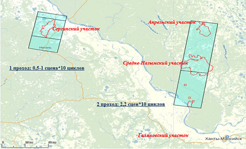
The peculiarity of the mutual geographical location of the sites determined the sounding scheme (Fig. 1):

1. The shooting of the Serginsky area was carried out with 1 standard or reduced passage (25-50 km in azimuth of shooting) in the amount of 10 cycles.

2. The shooting of the April, Middle Nazym, and Galyanovsky areas was carried out with a common passage with a size of at least 2.2 of the standard scenes (120 km of standard shooting) in such a way that the corresponding sections of 10 cycles were entered.


Outlines of scene in the AOI

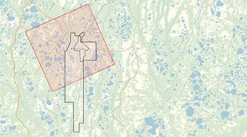
At the next stage, a satellite survey of the COSMO-SkyMed satellite (StripMap Himage) was carried out in the amount of fifteen scenes in the South Kustovoye field, including the city of Kogalym (total of 15 scenes). Mode - StripMap Himage. Polarization - HH.

 
The coverage scheme of the AOI

Рисунок-1---Контуры-сцен-на-зоне-интереса.jpg
Схема-покрытия-сценой-зоны-интереса.jpg
04

Result

Perm National Research Polytechnic University received the latest radar survey data, which was used for further interferometric processing and fulfillment of obligations to the main customer.

Need satellite imagery or help choosing the right data?

Describe your task, area of interest, and desired outcome. We will check data availability, assess new acquisition options, and propose the optimal solution in terms of timelines, cost, and quality.
clients who trust us
25+ years in the geodata market
Request a call back
Back to page top
Мы используем Яндекс.Метрика и собственные Сookies для обеспечения наилучшего опыта работы на нашем сайте, персонализации сайта для наших пользователей и аналитики. Продолжая использовать сайт вы соглашаетесь с условиями Пользовательского соглашения.