



A digital topographic site plan in the format, projection and CRS per the ToR, orthophotomaps, source images, instructions and a technical report.
Search the site
What the service is used for
Design and construction
Preparation of designs and construction of facilities of various purposes.
Above-ground buildings and structures
Construction of above-ground buildings or structures.
Underground structures
Construction of underground structures.
Construction and installation works
Carrying out various types of construction and installation works.
Site encumbrances
Establishing encumbrances on a land plot or any part of it.
Did not find your task?
Describe the territory, the plan scale (creation or update) and the purpose of the work. A specialist will assess the remote sensing archive and the composition.
What you will receive as a result of the work
01
Digital topographic site plan
Map products in the formats, projection, coordinate and height system agreed in the terms of reference.
A large-scale drawing of a plot of the Earth's surface in conventional symbols: situation, relief and terrain objects with technical and metric characteristics.
What you get
- creation or update of a digital topographic site plan
- export of the project to the required formats, projection and coordinate system
- sheet layout by nomenclature sheets or within the mapping territory
Object composition and semantic load are fixed in the terms of reference and the editorial and technical instructions.
02
Orthophotomaps and source imagery
Remote sensing materials: digital orthophotomaps and source images used for the plan.
Orthophotomaps are needed for interpretation and vectorisation of terrain objects; source images are delivered together with the products.
What you get
- digital orthophotomaps for creating or updating a topographic site plan
- source remote sensing materials
- a set of additional and reference materials used in the work
Availability of a remote sensing archive and the need for a new survey affect the timeline and cost.
03
Editorial instructions and report
Editorial and technical instructions and a technical report on the completed work.
The documents accompany creation and update of a digital topographic site plan.
What you get
- editorial and technical instructions for creating or updating the plan
- a technical report on the completed work
- delivery on electronic media or via FTP; text materials are also provided in printed form
The need to prepare and approve editorial and technical instructions is confirmed at the source-data stage.
04
Content of the site plan
Situation, relief and terrain objects in conventional symbols referenced to a coordinate system.
The plan shows hydrography, soil and vegetation, relief, the transport network, utilities, structures and plot boundaries.
What you get
- hydrography, soil and vegetation, terrain relief
- transport interchange, utility networks, including underground utilities
- structures with number of storeys and height characteristics, plot boundaries
The object composition depends on the scale: on plans of large territories small water bodies may be omitted.
How the work goes
Cost and timeline
The full cost of one nomenclature sheet consists of remote sensing materials for the orthophotomap, production work, plan scale, complexity category and timeline.
- consultation — free of charge
- image selection, preliminary analysis of source information, additional and reference materials — free of charge
- image ordering — from 0.5 to 70 USD per 1 km² (price table); the order steps state from 8 to 70 USD per 1 km² depending on the survey (archive or new, mono or stereo, resolution)
- digital orthophotomap creation — from 1 USD per 1 km²; calculated individually and depends on the volume of remote sensing data processed, presence or absence of ground control points and the DEM used
- creation (update) of 1 nomenclature sheet of a digital topographic site plan — from 40 000 rubles (scale, complexity category, turnaround time, number of nomenclature sheets)
- update — depends on how outdated the plan is, but not more than 50% of the creation cost
- work turnaround — from 20 working days (card, table, total in the stages block); in the FAQ the minimum time to create and deliver finished digital topographic site plans is from 5 working days
- creation of orthophotomaps for interpretation and vectorisation — from 5 working days from the date of receiving 100% advance payment for remote sensing materials
- start of interpretation and vectorisation of features — from 3 days after orthophotomap production starts
- payment: 100% prepayment by invoice after signing the contract (FAQ); remote sensing materials — 100% advance, bank transfer only
Creation of 1 DTP map sheet — from 40 000 rubles
Turnaround time — from 20 working days
Consultation and image selection — free of charge
What is needed for a quote
To agree the terms of reference and estimate creation or update of a digital topographic site plan, provide:
- coordinates of the mapping area (in any convenient format)
- scale and type of the topographic site plan being created or updated, presentation format, sheet layout (by nomenclature sheets or within the territory), projection, coordinate and height system
- availability of source map materials, additional and reference materials
- availability of ground-control-point coordinate lists for photogrammetric processing of remote sensing materials
- requirements for object composition and semantic load of the topographic site plan being created (updated)
- whether editorial and technical instructions need to be prepared and approved
If the listed information is not available, it is enough to describe the purpose of the topographic site plan and the types of work to be done with the plans.
Specialists will analyse the task and prepare a proposal for creating or updating a topographic site plan.
Why Innoter
Prompt access to archives
Suitable archive imagery can be obtained faster when the required area and date are already available from operators.
No aviation clearances
A new satellite survey does not require the flight clearances typical of aerial surveys.
Large and remote areas
A single satellite pass covers large areas and makes it possible to work in hard-to-reach regions.
Direct agreements with operators
Distribution agreements help select archive imagery and order new surveys from different providers.
Software and server infrastructure
Modern software and computing capacity for quality control and processing of large data volumes.
Experienced specialist team
Years of experience on complex projects and specialists in cartography, photogrammetry and remote sensing.
Scales, source data and work stages
The composition depends on the plan scale, archive or new survey, ground control points and the terms of reference.
1
A topographic site plan is a large-scale drawing of a plot of the Earth's surface in conventional symbols without accounting for the curvature of the geoid. The scale is constant in all directions.
The document is compiled from a topographic survey: the plan shows situation, terrain relief and objects with technical and metric characteristics.
Plans are produced at large scales from 1:5000 to 1:500 (the largest demanded scale: 1 cm of the plan is 5 metres on the ground) and do not account for Earth's-surface distortion. Maps are issued at smaller scales, cover larger territories and account for the curvature of the globe.
2
Permissible ground sample distance (spatial resolution of images), m:
- scale 1:500 — 0.1 m;
- scale 1:1000 — 0.25 m;
- scale 1:2000 — 0.5 m;
- scale 1:5000 — 1.25 m;
- scale 1:10 000 — 2.5 m.
For construction, 1:500 or 1:1000 plans are used in most cases. The most accurate are tree-by-tree plans and landscape surveys at 1:100 and 1:200.
3
Very-high- and high-resolution satellite imagery can be obtained faster: it may already be in the operator archives, and a new survey does not require approvals from competent authorities. Satellite imagery does not require a field visit, unlike aerial photography and UAV survey.
Aerial photography provides images with high spatial resolution (down to 1 cm/pixel) and a higher level of detail of orthophotomaps and models, a root-mean-square error (RMSE) of point coordinates of less than 10 cm, and can be performed under continuous cloud cover.
4
The main material is archive remote sensing data from spacecraft operators for the most current date, or a new survey. In addition, geographic descriptions, maps and atlases of a larger (smaller) scale, directories and customer data are used.
For an update, map products from the CGK&PD funds or products provided by the customer may be used.
5
Issue alignment, analysis of remote sensing data, source map materials, additional and reference materials: from 1 to 5 working days. Contract signing: from 1 to 5 working days. Receipt of images: from 3 to 10 days from the date of the 100% advance for remote sensing materials. Request and receipt of source map material from funds (if needed): from 1 to 20 working days. Digital orthophotomap creation: from 5 working days. Interpretation and vectorisation: from 15 working days. Adjacent-sheet joining and QC: from 5 to 10 working days. Report compilation: from 5 to 10 days. Total timeline: from 20 days.
Timelines depend on the number of nomenclature sheets, scale and type of product, availability of archive (existing) materials, additional and reference materials. Orthophotomap creation for interpretation and vectorisation — from 5 working days from the date of the 100% remote sensing advance; start of interpretation and vectorisation — from 3 days after orthophotomap start.
6
After 100% prepayment for the purchase of remote sensing materials: ordering of survey and fund data, collection of additional and reference materials, preparation and approval of editorial and technical instructions, incoming inspection of remote sensing materials, creation of digital orthophotomaps, interpretation of orthophotomaps (thematic processing of Earth remote sensing data) and vectorisation of terrain objects, visual and automated QC, export of the project to the required formats, projection and coordinate system, technical report.





Frequently asked questions
Answers to key questions about service parameters, timelines, deliverable formats and workflow. If you did not find what you need — contact us and we will help.
- area of interest (location / coordinates of the object in any convenient form, and area of the object);
- the specific problem to be solved using the digital topographic map
As the main material for execution (update) of the topographic site plan the Earth remote sensing materials available in archives of spacecraft operators for the most current date are used, or a new survey is ordered. Besides, when performing (updating) the digital topographic plan, additional and reference materials are used in the form of various geographical descriptions, maps and atlases of large (small) scale, reference books, as well as data available with the Customer. As an updated digital topographic plan can be used cartographic products available in the CGC&DP collections or cartographic products provided by the Customer.
- Terms of digital topographic plan based on space or aerial survey data depend on the volume and complexity of the order. Minimum term - from 5 (five) working days;
- Terms of delivery of finished digital topographic plans from 5 (five) working days.
100% prepayment by invoice after signing the contract
Saving on preparatory work is not always advisable. It is the basis for the preparation of other construction documents, and redrafting may entail significant costs. The cost of preparing a topographic plan varies depending on the detail and scale.
Topoplan is a schematic representation of the investigated land plot (terrain), on which the entire situation is displayed in conventional signs. They are created in a horizontal plane, where the parameters of objects are represented in a certain scale. In fact, a topographic plan is a projection of the terrain in a reduced form with height marks and binding to the coordinate system.
Inscriptions are made by certain cartographic fonts, taking into account the rules of location on the right of the scheme.
Map and plan in topography are identical concepts. The difference is that a map is provided on a smaller scale and covers larger areas, taking into account the curvature of the surface of the globe. Plans do not take into account the distortion of the land and are carried out in large scales from 1:5000 to 1:500, ie the largest demanded scale in 1 cm. plan 5 meters of land.
Topographic site plan significantly accelerates engineering and construction surveys for the construction of facilities on the site.
The plans shall note:
- Hydrography (water bodies. Plans depicting large areas of terrain do not indicate small water bodies);
- soil and vegetation;
- terrain;
- transportation interchange;
- engineering networks (including underground communications);
- structures (with indication of storeys and height characteristics);
- site boundaries (lands, gardens, forests, fields, etc.).
In the overwhelming number of cases, topoplanes are created at a scale of 1:500 and 1:1000, which ensures high accuracy and detail. The most accurate are sub-tree plans and landscape survey, executed at a scale of 1:100 and 1:200. (vegetation; detailed relief; hydrographic elements; buildings and structures; anthropogenic changes in the earth's crust are displayed).
It is only through a topographic plan that designs for complex structures are created. Whether it is a power line, a transportation highway, a residential building or an industrial facility. All structures occupying a significant area are built on the basis of a topographic plan of the land plot.
Electronic formats are stored forever (The electronic version is created in a specialized program and given to you on a storage medium. In special cases, volumetric 3D models are projected). But any topographic plan is valid for three years, then you will have to rescan the area.
Construction projects are currently created only in electronic format and, if necessary, transferred to paper. Computerized schematics are more accurate and visually convey all the characteristics of the site.
Pay attention to the companies that use their equipment. It is they who will be able to make an accurate plan of the land plot with all its boundaries and construction objects.
Surveying is done using geodetic equipment, total stations, GLONASS/GPS equipment. Thanks to this it is possible to obtain certain results of measurements of the plane of the site. Therefore, even in conditions of high dustiness, humidity, it provides accurate measurements
- Customer's passport.
- Terms of reference. If possible, it specifies all wishes and nuances.
- Contract on the lease of the land plot or extract from the USRN.
- Made plans (if any).
The preparation of the plan and other documents for a building permit is better to make out in one organization, since another will not take responsibility for incorrectly prepared documents.
are drawn up mainly at a scale of 1:500 and include underground utilities. More than others requires approvals, stamps and accreditations
It is depicted in the form of horizontals. Those relief elements, which cannot be shown by horizontal lines, are marked by means of special conventional signs.
For private needs and single-storey construction, the plan is not obligatory, but it will be useful when registering land for lease or ownership.
Topoplan can also be prepared independently, but only for your own use. In the case of tasks, where the scheme is included in the documentation package, it should be prepared only by surveyors, as a self-prepared document will not have legal force.
Before starting field work, geodesists are engaged in checking the available materials. After that, geodesists and cadastral engineers start working on the ground: they perform a topographic survey of the object with calculation of distance, height of coordinates of turning points. The information obtained will be used in calculations.
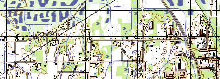
CONDITIONAL SIGNS FOR TOPOGRAPHIC PLANS of scales 1:5000,1:2000,1:1000,1:500
SP 47.13330.2012 "ENGINEERING SURVEYS FOR CONSTRUCTION. BASIC PROVISIONS"
SP 11-104-97 "ENGINEERING-GEODETIC SURVEYS FOR CONSTRUCTION"
GOST R 51872-2002 "GEODETIC EXECUTIVE DOCUMENTATION"
Topographic site plan
The topographic site plan must meet certain requirements. The scale of the plan is selected based on its intended purpose. Maps with small scales do not allow for the detailed representation of individual objects. For construction purposes, plans with scales of 1:500 or 1:1000 are commonly used. The document may include not only the scheme of the site but also additional images.
Objects and Features Depicted on the Plan Using Conventional Symbols:
- Relief: Represented by contours. Elements of relief that cannot be shown by contours are marked using special conventional symbols.
- Landmarks: Objects that can be used as reference points. They are depicted with non-scale symbols and precisely linked to coordinates.
- Transportation Network: Detailed representation using conventional symbols for various types of roads.
- Hydrography: Large lakes, swamps, rivers, and other water bodies are displayed on topographic plans with names, depths, etc.
- Soil-Vegetation Cover: Represented by specific non-scale symbols and colors.
- Engineering Communications: Both above-ground and underground communication lines are indicated on topographic plans.
The topographic site plan can be presented in various formats:
- On paper. This is the standard format and is often required for various approvals.
- In digital format. It can be a digital terrain model or a topographic plan in PDF format. The plan is certified with an electronic-digital signature.
Types of Engineering Topographic Plans
Depending on the level of detail in the representation, topographic maps are divided into several types:- Geodetic Base
- Horizontal Survey Plan
- Tree Survey Plan
The process of creating a topographic plan includes the following stages:
- Preparation of Technical Task (Geodesists prepare cartographic materials based on the Technical Task. The Technical Task for topographic survey is the primary foundational document that initiates the formation of contractual obligations between the parties. In case of any disagreements, all disputes and settlements will be based on this approved and signed document. It is crucial to consider all important details in the Technical Task; otherwise, oral agreements may simply be disregarded.)
- Contract
- Preparation
- Fieldwork
- Deskwork
- Approval
Land surveying includes a whole complex of geodetic works, collection and study of documents, the process of boundary coordination, preparation of boundary surveying file, cadastral registration and obtaining documents for registration of ownership rights.
Surveying is a geodetic method of measuring the boundaries of a land plot in the horizontal plane. In short, it is the determination of the boundaries of a land plot and their legal registration.
This type of plan is carried out to determine the boundaries of plots and objects located on the surveyed territory. It also calculates the areas of land plots and considers their mutual arrangement.
The peculiarity of horizontal survey - Usually, such a scheme does not contain information about the relief and heights. It is necessary for land division, accounting for land plots, etc. Such plans are in demand when dividing land in cottage cooperatives or determining the sizes of undeveloped land.
Clarification of the boundaries of the land plot are certain geodetic works, which are associated with the definition of the coordinates of such a plot, its dimensions, also features, then all these parameters are agreed with the neighbors.

Need satellite imagery or help choosing the right data?
Describe your task, area of interest, and desired outcome. We will check data
availability, assess new acquisition options, and propose the optimal solution in terms of timelines, cost,
and quality.
Discuss the project
clients who trust us
25+ years in the geodata market







