Radar imaging (SAR) is a type of space imaging that uses the microwave radiation range with wavelengths from 1 cm to 1 m to obtain information. SAR is an active method of remote sensing. Satellites are equipped with synthetic aperture radar (SAR), which allows for imaging.
The first SAR tests were conducted in the USA and the USSR in the 1960s for ship detection in high latitudes and other military purposes. In 1968, the Laboratory of Aeromethods of the Ministry of Geology of the USSR began the first tests of area radar aerial photography for geological purposes. Soviet side-looking radar systems (SLRS) "Toros" and "Nith" were used in the tests. The first space radar imaging with a resolution of 25 m was carried out in 1978 from the SeaSAT satellite. In 1981, images with a spatial resolution of 40 m were taken by the space shuttle. The active use of radar imaging began in 1991 with the launch of the ERS-1 satellite with a radar. Initially, the purpose of using the first civilian radar satellite with medium spatial resolution (20 m) was limited to monitoring the seas. However, after the satellite completed several full orbits around the Earth, it was found that, besides marine applications, this satellite had great potential for solving various tasks on land.
Table 1. The most common radar imaging bands
|
Band |
Frequency, GHz |
Wavelength, cm |
Satellite systems |
|
X |
5.2–10.9 |
2.75–5.77 (2.4–3.8) |
Iceye |
|
C |
3.9–6.2 |
3.8–7.6 |
|
|
L |
0.39–1.55 |
19.3–76.9 (15–30) |
SIR-A,B JERS |
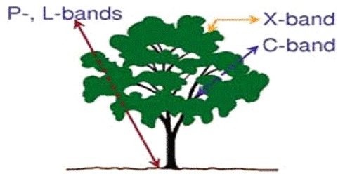
The principle of operation of a radar satellite: the spacecraft sends a radar signal in the microwave range, which reaches the Earth's surface and is reflected from it, as well as partially penetrating inside. The radio signal can penetrate to a depth equal to half the wavelength. The intensity of the reflected signal is determined by the surface properties (roughness, moisture, orientation in space, slope steepness, dielectric constant, etc.) and the wavelength of the radiation, so different ranges of imaging are suitable for different tasks (Fig. 1). After this, the reflected signal returns to the satellite and is recorded.