of geospatial solutions
Sat-Sun: Non-working days
Customer
Gazprom OJSC
Project's objective
Receiving situational space maps with vector layers of objects provided on them, provided for by the Terms of Reference (wells, loops, reservoir, hydraulic fracturing platform and CS, outlines of mining allotment)Completed work
Work description
I. SEARCH FOR ARCHIVE SATELLITE IMAGES
A search for space images of high spatial resolution (from 0.5 to 5 m – depending on the availability in the archive) was conducted on the area of mountain branches of the following UGS facilities of the Russian Federation: Schelkovskoye, Kalugskoye, Kasimovskoye, Uvyazovskoye, Sovkhoznoye, Nevskoye, Leningradskoye, Krasnodar, Kushchevskoye, Punginskoye Karashur.
1. Reception from the Customer of the specified sites UGS in the form of digital files;
2. The search for high-resolution space images from 50 cm to 5 meters to UGS areas. The search was carried out among the following space images:
-
WorldView-1 (resolution – 50 cm);
-
QuickBird (resolution – 70 cm);
-
Ikonos (resolution – 1 m);
-
OrbView-3 (resolution – 1 m);
-
Kompsat-2 (resolution – 1m);
-
ALOS PRISM (resolution – 2,5 m);
-
SPOT-5 (resolution – 2,5 m)
3. Criteria of digital information selection:
-
selection of the most recent by date and the best image quality,
-
the presence of cloud cover – no more than 10%;
-
the relevance of shooting – the date of shooting no later than 2004;
-
angle of deviation of shooting from nadir – no more than 30%.
4. Production of cartograms of the UGS plots coverage with space images.
5. Order of space images.
II. DIGITATION OF AVAILABLE CARTOGRAPHIC MATERIALS AND REDUCING THEM TO A UNIFIED COORDINATE SYSTEM
The available non-geographic map materials for the UGS of the Russian Federation on paper or in electronic format (in * jpg, * cdr, * ppt, * doc, etc.) formats were digitized using the MapEdit and ArcGIS software. The object classes provided for the Terms of Reference were subject to digitization.
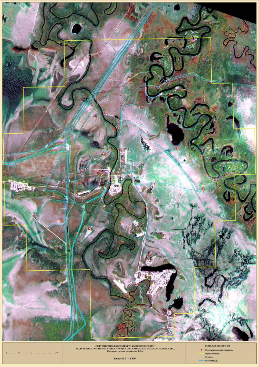
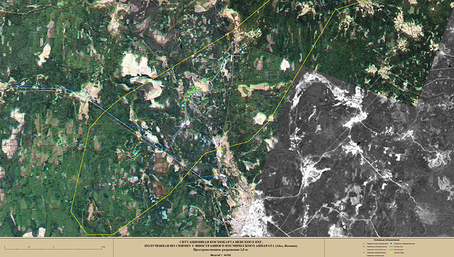
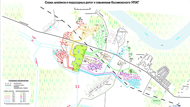
Then, on the high-resolution optical satellite images previously found in the archive, some reference objects were found that are also present on the original cartographic materials. After identifying several such reference objects on satellite images, the geo-referencing of the initial cartographic materials and the vector layers digitized from them was performed. As a result, situational space maps were obtained, representing a background substrate from high resolution satellite images with vector layers of objects provided by the Terms of Reference (wells, loops, reservoir, hydraulic fracturing platform and CS, outlines of mining allotment).
At the next stage, the spatial location of each specific object placed on the spacemap was refined. For example, production well sites are clearly visible in satellite imagery, and their location in most cases was refined using space imagery data by visual interpretation. The location of gas pipelines (loops and collectors) was not always possible to be determined by visual interpretation of satellite images and, in such cases, a comparative analysis of various available materials was performed. In some cases, consulting the Customer’s specialists was required to clarify the location of specific objects.
Note that on the resulting spacemaps, individual loops of each well and loops that collect gas from several wells are shown with one conventional sign. Some groups of closely spaced individual loops, laid in a single bundle, were shown on the cards with a single line, in order not to overload the drawing.
The mapping information systematized in this way was integrated into the geographic information system. The resulting database of geo-positioned spatial data became the basis for obtaining output map products.
The terms of reference also provided for obtaining, at the exit, situational space maps of underground gas storages of the Russian Federation at scales of 1: 5000 – 1: 10000 with the display of individual infrastructure elements (such as hydraulic fracturing platforms and CS) at scales of 1: 1000 – 1: 2500.
III. ANALYSIS OF THE SITUATIONAL SPACE MAPS FOR THE EXISTENCE OF THE LIMITATIONS OF THEIR USE IN THE PART OF THE STATE AND COMMERCIAL SECRET
The general procedure for obtaining and using geospatial data, including remote sensing data from Earth, is defined in the “Regulations on the procedure for obtaining and submitting geospatial information”, which was approved by the Government of the Russian Federation dated May 28, 2007 No. 326. In accordance with this resolution and the subsequent explanations of the General Staff of the Russian Armed Forces space images (including those with a resolution better than 2 m in terrain) obtained from foreign spacecraft are not secret.
Situational spacemaps of UGS RF are based on satellite images obtained from foreign spacecraft: Quickbird and WorldView (USA), ALOS (Japan), SPOT (France), and, therefore, they are not secret.
From the point of view of compliance with the Commercial Secret regime, a list of information constituting a commercial secret, approved by the Order of Gazprom, was analyzed. According to the analysis of this list, the following conclusions were made:
-
The original satellite images taken from foreign spacecraft are not a commercial secret, since they are in the data bank of the respective distributors in the public domain (i.e., any natural or legal person can acquire them at any time);
-
On the situational space maps supplied to the Customer, there is no coordinate grid, and therefore it is impossible to determine or clarify the coordinates of the UGS ground infrastructure objects (exploration and production wells, main and field pipelines, other technological objects) in the state or other coordinate system, and the space image itself, against the background of which UGS facilities are displayed, is neither secret nor confidential, as explained above;
-
Information about the location and occurrence of productive strata and effective gas-saturated UGS thicknesses are not shown on situational space maps;
-
No additional topographic information, except for the information contained in the original non-secret and non-confidential space images, is not applied to space maps.
Results
Thus, considering the relevant items of the List of information constituting a commercial secret, the resulting situational space maps, in the authors' opinion, do not represent a commercial secret. The final decision on the confidentiality and secrecy regimes of situational space maps of the UGS facility of the Russian Federation is made by the Customer (OAO Gazprom).
Need for consultation?
Fill the form and we will contact you
Sat-Sun: Non-working days