Contact

Assessment of the conformity of parcel boundaries with actual cadastral data and identification of changes over time using satellite imagery

01

About the project

The client turned to the Innoter Geospatial Agency for assistance in compiling a body of evidence. The Ministry of Natural Resources had filed a complaint against the client, alleging that the subsoil user had exceeded the boundaries of the leased license area and caused damage to the topsoil.

Industry Forensic expertise
Customer

Confidential

Region: Republic of Sakha (Yakutia)

Project timeline: June–July 2025

End date 09/05/2025
02

Project goal

The client contacted Geospatial Agency INNOTER for assistance in preparing an evidence base. A claim had been brought against the client by the Ministry of Natural Resources, alleging that the subsoil user had operated beyond the boundaries of the leased licensed area and caused disturbance to the fertile topsoil layer.

Risks for the Client

  • Imposition of a substantial financial penalty;
  • Obligation to reclaim and restore disturbed land;
  • Possible suspension or revocation of the subsoil use license;
  • Early termination of the right to use subsoil resources within the leased licensed area;
  • Administrative liability and, in the worst-case scenario, criminal liability;

Objectives of the Expert Assessment

  • Identification and delineation of the boundaries of the two land plots under investigation based on the provided coordinates.
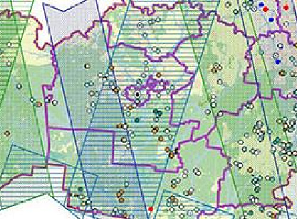
  • Certification and authentication of satellite imagery by the GEO INNOTER laboratory.
  • Interpretation of the sites using visual and automated methods, and overlaying the boundaries on satellite imagery using specialized software.
  • Comparison of the boundaries of the investigated areas with the official cadastral boundaries of the site.
  • Analysis of changes in area and boundary position, and identification of any encroachment beyond the cadastral boundary.
03

Completed works

  1. Use of satellite imagery with ultra-high spatial resolution of 0.3 and 0.5 meters from 2022 and 2025
  2. Official cadastral data from the National Spatial Data System.
  3. Software: QGIS, ENVI, ScanEx Image Processor.
  4. Verification and certification of satellite imagery, including verification that no alterations have been made to it
  5. Application of visual interpretation, atmospheric correction, and orthorectification methods; merging of panchromatic and multispectral channels; cartographic analysis; area calculation; and analysis of the relative positions of boundaries
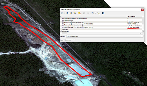
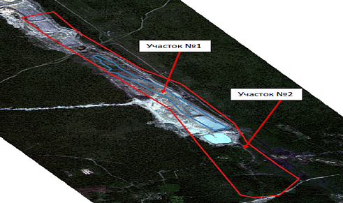
  • Study Area No. 1 was identified based on the coordinates provided by the Client; its area was approximately 30.7 thousand m² (Fig. 1).

Fig. 1 - Area of Study Area No. 1 (red polygon) on the image dated July 1, 2022.

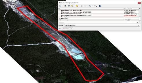
  • Study Area No. 2 was identified based on the coordinates provided by the Client; its area was approximately 248.8 thousand m² (Fig. 2).

Fig. 2 - Area of Study Area No. 2 from Table No. 2 (red polygon) on the image dated July 1, 2022.

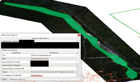
  • The cadastral parcel was confirmed; its area was approximately 553.2 thousand m² (Fig. 3).

Fig. 2 - Layout of the study area with the cadastral number (green polygon) on the image dated July 1, 2022.

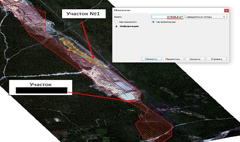
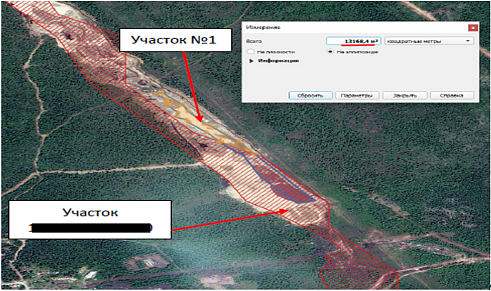
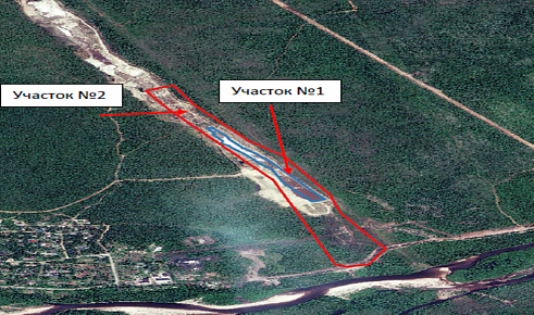
  • It was established that Study Area No. 1 extends beyond the boundaries of the cadastral parcel by approximately 13.1 thousand m², but is entirely located within the boundaries of Study Area No. 2 (Figs. 3-4).

Fig. 3 - Overlay of Study Area No. 1 (blue polygon) on the boundaries of the parcel with the cadastral number (red hatched polygon) on the image dated July 1, 2022.

Fig. 4 - Overlay of Study Area No. 1 (blue polygon) on the boundaries of Study Area No. 2 (red polygon) on the image dated July 1, 2022.

  • Analysis of imagery from 2022 and 2025 showed no changes in the boundaries of the study areas (Figs. 5-6).

Fig. 5 - Overlay of Study Area No. 1 (blue polygon) on the boundaries of the parcel with the cadastral number (red hatched polygon) on the image dated June 18, 2025.

Fig. 6 - Overlay of Study Area No. 1 (blue polygon) on the boundaries of Study Area No. 2 (red polygon) on the image dated June 18, 2025.

    04

    Result

      Project Significance

      The expert assessment made it possible to confirm the actual location and boundaries of the subsoil use area and to establish that the Lessee had not extended its activities beyond the boundaries of the licensed area.

      The results provided an independent evidence base that helped the Client challenge the claims of the regulatory authorities and protect its rights. As a result, a monetary fine amounting to tens of millions of rubles for violation of the environmental legislation of the Russian Federation was not imposed on the Client, and no restrictions were placed on the further use of the subsoil area.

      Thanks to our specialists, the Client received an expert assessment with legal standing in court within a short timeframe and at a reasonable cost.

      Expert Opinion

      For the Client, our satellite imagery-based expert assessment service became the last opportunity to prove its position and avoid negative consequences from the Ministry of Natural Resources. A key factor was the lawyer’s awareness that such an expert assessment was possible. In many cases, lawyers do not receive information during their university education or subsequent professional training about the use of geospatial technologies for protecting their clients’ interests. By engaging GEO INNOTER — which has its own laboratory for the analysis and certification of Earth observation imagery, satellite image interpretation technologies, GIS specialists and cartographers, as well as certified experts — the defense was able to substantiate its position and successfully protect the Client’s interests.

      Need satellite imagery or help choosing the right data?

      Describe your task, area of interest, and desired outcome. We will check data availability, assess new acquisition options, and propose the optimal solution in terms of timelines, cost, and quality.
      clients who trust us
      25+ years in the geodata market
      Request a call back
      Back to page top
      Мы используем Яндекс.Метрика и собственные Сookies для обеспечения наилучшего опыта работы на нашем сайте, персонализации сайта для наших пользователей и аналитики. Продолжая использовать сайт вы соглашаетесь с условиями Пользовательского соглашения.