your companion in the world
of geospatial solutions
Operation mode:
Mon-Fri: 10:00 - 18:00
Sat-Sun: Non-working days

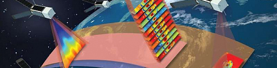
Geological exploration for mineral resources (Geological mapping) using Remote Sensing (RS) methods - non-traditional exploration for indirect presence of mineral resources based on satellite, aerial, and UAV sensors in a wide electromagnetic spectrum.

Images are collected either through optical sensors or radar sensors with synthetic aperture. Optical sensors measure spectral data of sunlight reflected from the Earth's surface. Synthetic aperture radar (SAR) sensors can detect electromagnetic data by transmitting microwave radiation and receiving backscattered waves from the Earth's surface.

Remote sensing images are used for indirect exploration of valuable mineral deposits in two key ways:

  • Mapping and analyzing the geology, faults, and fractures of the ore deposit.
  • Identification of hydrothermally altered rocks based on their spectral characteristics.

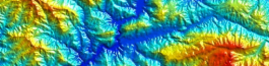
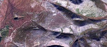
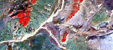
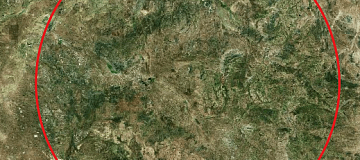
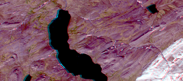
Mapping hydrothermal alteration minerals and structural lines, for example, using multi-spectral images from satellites like Landsat 8 (or Aster), provides valuable information for mineral exploration. For instance, gold mineralization occurs as quartz veins and stringers associated with hydrothermal alteration halos. Faults are interpreted as pathways for mineralizing fluids, where the interaction between host rocks and hydrothermal fluids causes variations in composition. Detecting these features using RS methods is a key indicator for targeting new prospective areas of orogenic gold mineralization. For example, remote sensing image processing methods such as band combinations, band ratios, and principal component analysis (PCA) have been applied to visible, near-infrared, and short-wave infrared ranges from Landsat 8 satellite.

Purposes of Prospecting for Mineral Deposits (Geological mapping)

Indirect support for main traditional prospecting activities on mineral resources by reducing significant investments in geological exploration. In such conditions, the implementation of innovative and cost-effective methods, such as remote sensing, becomes particularly relevant.

Remote Sensing is a valuable tool for geologists, providing relevant information while saving time and resources. It is best suited for locating high-value mineral deposits, such as diamonds and gold. Although remote sensing cannot precisely pinpoint the location of large ore bodies, the data obtained from it can be used to narrow down prospects through other means in smaller areas.

In the last 10-15 years, there has been a significant technological breakthrough in terms of improving the quality and availability of satellite imagery. This has led to a reevaluation of traditional approaches to mineral resource forecasting.

Global experience in using Remote Sensing methods has proven their effectiveness in locating copper-porphyry, gold, and other deposits in countries like Iran, Argentina, China, USA, Canada, and more. Across the world, the preparatory stage of geological exploration includes Remote Sensing methods, but Russia is currently lagging behind. Free satellite images from ASTER, Landsat ETM+, Landsat-8, and recently made publicly accessible, have been successfully utilized in the field of geology.

The introduction of commercial satellite imagery from Worldview-3 (8 SWIR 3.7m + 8 MS 1.24m + PAN 0.31m) has significantly improved the efficiency of preliminary geological exploration or the refinement of previously explored deposits.

Geo Innoter is the only company in Russia whose specialists have undergone multiple training sessions in the application of Remote Sensing by the industry leader MAXAR (USA) for geological tasks!

Работник

Purposes and Objectives of Prospecting for Mineral Deposits (Geological mapping):

Mineral exploration is a task that geologists must approach with the maximum possible information. Rare metals and valuable minerals can easily be overlooked, and the process of their discovery involves costly risks.

In general, remote sensing is used in geological exploration to accomplish the following tasks:

  • Mapping of deposits and host rocks.
  • Lithological mapping.
  • Structural mapping.
  • Exploration of mineral deposits.
  • Study of the geology of the surrounding environment.
  • Study of geobotany.
  • Mapping and monitoring of sedimentary deposits.
  • Mapping and monitoring of potential hazards.
  • Monitoring of deformation and displacement of the earth's surface in mineral deposits.

Advantages of Using Remote Sensing:

  • Remote Sensing is a valuable tool in mineral exploration (geological mapping) due to its ability to save time and money while providing useful information. It is best suited for detecting valuable commodities such as diamonds and gold, which are becoming increasingly difficult to find. Although remote sensing methods may not precisely identify the location of large deposits, the data collected from sensors can be used to narrow down field investigations to smaller areas.
  • Remote Sensing tools are beneficial for risk reduction and prioritization in exploration projects. Expensive operations like drilling and fieldwork can be conducted after collecting and analyzing geospatial data.
  • The ability to synthesize different forms of data is a significant achievement in mineral exploration (geological mapping). Known drilling results can be integrated with topographic maps, aerial imagery, structural maps, and ore content information. Data synthesis can significantly enhance the accuracy and efficiency of exploration programs.

The application of Remote Sensing methods allows for a drastic reduction in the cost of geological exploration by conducting comprehensive research of extensive territories, often inaccessible for traditional exploration methods due to various reasons.

In combination with traditional methods (geological, geophysical, geochemical, etc.), Remote Sensing methods allow for a more objective understanding of the structure of the lithosphere, geological processes, the effectiveness of prospecting deposits, and the analysis of the environmental impact.

The application of Remote Sensing methods significantly reduces the cost of mineral exploration (geological mapping):

  • It reduces financial and time expenses for ground exploration and the use of equipment and personnel.
  • Geological exploration reaches a qualitatively new level.
  • High speed of obtaining information: from 1-2 days to several weeks.
  • High accuracy of information: space images document specific locations at specific times.
  • Significantly broader coverage: Remote Sensing allows for simultaneous imaging of large areas with high accuracy, exploration of inaccessible regions and sites, localization of exploration, and simultaneous observations in different areas.
  • No need to be bound by national or other borders; no special permits required.
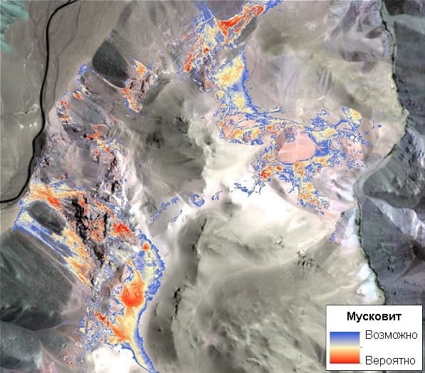
Image

Fig. Muscovite

The use of remote sensing methods and tools reduces the risk of implementing geological exploration projects, helping to establish the priority of exploration of different areas based on their prospects. After completing such works, more expensive exploration methods, such as geophysical surveys (including magnetic surveys, electrical surveys, and magnetometry), are used.

The ability to synthesize various data types has been a tremendous step forward in geological exploration. For example, geophysical results can be combined with topographic maps, aerial imagery, structural maps, and information on the content of valuable components, such as gold. Data synthesis significantly enhances the accuracy and efficiency of exploration work.

Prices for services

The table provides information about the cost of various services related to remote sensing and geological exploration:
Consultation Free
Selection of Images, Preliminary Analysis, and Technical Task Compilation Free
Ordering of Images

The cost of remote sensing materials is calculated individually for each order and may vary:

- Using free satellite images

- and/or using commercial satellite images*
Work of Technical Specialists and Expert(s) From 10,000 USD
TOTAL COST From 10,000 USD

* - if the Client does not provide their own materials, or it is not possible to use free images.

The cost depends on various factors, including:

  • Area of interest (region);
  • Type of imagery - archive / new, free images / paid;
  • Number of images;
  • Quality characteristics of the images;
  • Complexity of the terrain;
  • Seasonality;
  • Advance payment size;
  • Required computational power;
  • Geological complexity of the area;
  • Whether materials need to be purchased or provided by the Client;
  • And more.
Please note that the cost estimation is done individually for each project, and these figures serve as general information. The actual cost of the service will be determined based on the specific requirements and needs of the project.

The cost of execution is calculated on an individual basis, taking into account a specific of task.

After receiving the task description, we calculate the cost and send you a commercial offer.

Period of execution

The completion timeframe for geological exploration of mineral deposits is 20 working days from the date of receiving the advance payment. However, it is important to note that the actual timeframe for providing the service will be determined individually for each customer based on specific project requirements and needs. The service completion timeframe depends on several factors, including:
  • Total area of the area of interest;
  • Availability of archived remote sensing materials and the need for new imaging;
  • Requirements for remote sensing materials and the final product.
The complexity of the project and specific customer requirements will also influence the service completion timeframe. As such, the timeline for delivering the service will be tailored to meet the unique demands of each customer. The complexity of the project, data processing, and analysis requirements will all be considered in determining the specific completion timeframe.

How to place an order:

  1. Step №1: Leave an application on the website with the following details:
    • Location of the research object (coordinates);
    • Questions;
    • Dates for which the analysis is required.
  2. Step №2: Approval of the technical task and cost:
    • Research starts from 10,000 USD;
    • Images are paid separately.
  3. Step №3: Sign the contract and proceed to execution:
    • Timeframe is 20 business days from the date of receiving the advance payment - payment only by bank transfer

Need for consultation?

Fill the form and we will contact you

By clicking the «Send» button, you give your consent to the processing of your personal data, in accordance with Federal Law No. 152-FZ of July 27, 2006 «On Personal Data», on the conditions and for the purposes specified in the Consent to the processing of personal data.

Stages of service provision

  1. Stage № 0 (BEFORE contract conclusion):

    • Obtaining and coordinating information from the Customer. It is necessary to coordinate the task requiring a solution, size, terrain characteristics, and product creation requirements to calculate the cost and timing of the services.

    RESULT: possibility (YES/NO) of providing the service

  2. Stage № 1 (BEFORE contract conclusion):

    • Agreement on the technical task
    • Collection, systematization, and preliminary analysis of remote sensing data (Terra / Aster, Landsat / ETM+, Hyperspectral, Hyperscan, SWIR, etc.);
    • Planning of the survey. The best survey geometry is calculated after a comprehensive geological analysis of the area for exploration, taking into account the available archive of remote sensing data.
    • Collection for creating a vector topographic map with the search area at a scale of 1:10,000 - 1:50,000.
    • Final determination of labor and material costs, agreement on timing and cost.

    RESULT: concluded contract

  3. Stage № 2 (contract execution):

    • Survey execution in all available electromagnetic spectrum ranges, preliminary processing, and delivery of remote sensing data to the Customer's sites.
    • Analysis of materials to build structural geological models on minerals and creation of a fund of spectral signatures for associated rocks and areas of the Customer's interest.
    • Selection of the reference library of mineral and rock spectra for ore zone alterations based on known deposits/showings, selection of the most informative indicator minerals.
    • Processing of existing geological information to create comparative references.
    • Creation of 1:50,000, 1:25,000, and 1:10,000 scale mineral-indicator maps
    • Creation of complex anomaly maps created by analogy with reference objects
    • Creation of prospecting geological maps
    • Preparation of a report, containing explanatory text for the created cartographic materials, as well as recommendations for selecting prospective areas for field verification

    GEО INNOTER uses spectral and subpixel analysis methods (but not limited to): 

    • principal component analysis (Principal Components); 
    • spectral angle method (Spectral Angle Mapper); 
    • Minimum Noise Fraction Transform; 
    • Pixel Purity Index; 
    • Multi-range spectral feature fitting (Multi Range SFF); 
    • structural decoding; 
    • calculation of mineralogical indexes;
    • and others.

    RESULT: Delivery of materials to the Customer

Image

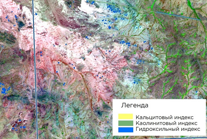
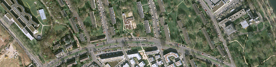
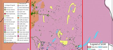
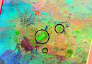
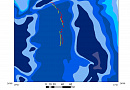
Figure. Example of mineral-indicator map, decoding of ASTER data

The result of the provision of services

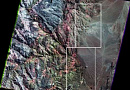
Our team, during project execution, relies on a comprehensive interpretation of both medium and high-resolution satellite images, thematic maps of the area's structure, and classical representations of the region's geology described in the literature. This approach helps achieve the best results, which will be taken into account in the search for deposits during subsequent field verification.

Using structural (lineament) and spectral analysis, we perform the following:

  • Cartography of linear, curvilinear, and circular structures that are potentially ore-hosting or ore-conducting channels.

  • Detection of contrasting geological formations (including based on machine learning classification).

  • Precise delineation of geological bodies outcropping on the surface and located under Quaternary deposits.

  • Tectonic zoning of the territory.

  • Refinement or optimization of the drilling plan, including existing ones.

  • Geological and geomorphological mapping of the region.

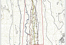
The Customer receives a geological map indicating the areas for field exploration, which are close to achieving success.

The maps are provided in PDF, GeoTIFF, and contour lines (shp format).

In addition, geologists are involved in on-site laboratory studies and major geophysical work.


Requirements for source data

Accurate geographic coordinates of the object in the required coordinate system (specialists of GEO INNOTER will refine the coordinates provided by the Customer in any convenient form).

A set of optical, infrared (near and thermal), and radar images.

All available geological maps of the search area.

Software:

  • GIS - QGIS, ArcGIS, etc.
  • Processing - ERDAS, ENVI SARscape, SNAP, etc.

Related services

Digital elevation models (DEM)
Find out the price
Satellite & UAV Monitoring
Find out the price
Aerial & UAV imagery
Find out the price
Thematic mapping
Find out the price
Remote sensing data
Find out the price
Космический мониторинг территории
Find out the price
Космическая съемка земли
Find out the price
Составление тематических и специальных карт, планов
Find out the price
Цифровые модели рельефа (ЦМР)
Find out the price
Аэрофотосъемка (АФС / БПЛА)
Find out the price
Zazulyak Evgeny Leonidovich
The material was checked by an expert
Zazulyak Evgeny Leonidovich
Engineer, 28 years of experience, Education - Moscow Topographic Polytechnic Technical School, St. Petersburg Higher Military Topographic Command School named after Army General A.I. Antonov, Military Engineering University named after V.V. Kuibyshev. Kuibyshev Military Engineering University.

Customers

Роснефть
Газпром
Газпром нефть
Лукойл
Транснефть

FAQ

Direct identification of, for example, ore-bearing gold by remote sensing is unlikely because there is little of it in the rock, so the contribution of "light" from gold particles will be suppressed by the "light" of the rock. Therefore, only indirect identification of ore-bearing rocks by the "color" of the rock or other known criteria of gold content of the environment is possible.
It is not at all necessary to know the intricacies of aerial and space surveying, as it uses the final materials in the form of geologic anomaly maps (color, intensity, etc.).
  • The algorithm of the remote sensing method in most cases is constructed as follows:
  • Reference objects of similar deposits or mineral deposits close to the area of study (gold, diamonds, platinum, copper, etc.) are selected in geological funds.
  • On the selected objects study the features of multispectral, radar, hyperspectral and geophysical surveys and identify patterns, create spectral signatures of reference objects.
  • They create a data bank of spectral signatures and identify features that are used later as search criteria.
  • Using these search attributes, an analysis is performed on all images of the electromagnetic spectrum for a given area.
  • Comprehensive analysis helps to identify a promising area and structure for further mineral prospecting.
Usually geological maps in Russia correspond to a scale of 1:50,000. But it is possible to obtain maps at a scale of 1:25,000 -1:10,000 using remote sensing to match the next stage of prospecting work, namely geophysical work.
The success of remote sensing technology largely depends on the competence of prospecting geologists, their ability to analyze and synthesize. In general, their ability to correlate geologic information.
Region, for example, rich in gold are Aldan, Mamsko-Chuysky district, along the Lena River. Traditionally: Yakutia, Kolyma, Krasnoyarsk Territory, Amur Region. Large mines are located in the north, in Norilsk.
Over the last 10-15 years there has been a significant technological breakthrough related to the improvement of quality and availability of space images. This made it possible to revise traditional approaches to mineral resources forecasting. The world experience of using remote sensing methods has proved its efficiency by the example of searching for copper porphyry, gold and other deposits in Iran, Argentina, China, USA, Canada, etc. All over the world the preparatory stage includes remote sensing methods in the field of exploration, but Russia is still lagging behind. Free space images ASTER, Landsat ETM+, Landsat-8 are used, which have become publicly available relatively recently, besides, these data have proven themselves in the field of geology.
Mandatory field certification is required, as each method allows to define mineral groups with a certain accuracy. These methods were used in combination with traditional geological methods, which allowed to significantly reduce the time of work and reduce the costs of exploration. Based on the study of reference fields, methods of complex analysis of space (including radar), gravimetric and magnetometric survey materials were developed to identify patterns of gold mineralization location
Objectives and principles of exploration of solid mineral deposits. The purpose of exploration is to identify commercial deposits of minerals, obtain mineral reserves explored in the subsoil and other data necessary and sufficient for the rational design and subsequent operation of mining and processing enterprises.

Exploration of mineral deposits

Exploration works are more labor-intensive and expensive than prospecting works. They require a greater volume of both labor, material and energy costs, which are similar in structure to the costs of mining and capital works. These costs should be linked to a gradual progressive increase of exploration information up to optimal volumes (for a certain period), ensuring quality and reliability. As a consequence, the exploration process, unified in methodological terms, develops as if in stages, called stages.

The exploration stage combines a set of geological and exploration works carried out in the field as a whole or in its part in order to solve the tasks set by the project to study the geological heterogeneities of the object, calculate reserves and geological and industrial evaluation.

Initial stage of exploration of mineral deposits

Initial {preliminary) exploration of mineral deposits is carried out after the prospecting and evaluation stage and continues at a higher qualitative level to obtain reliable information capable of providing a reliable geological, technological and economically justified assessment of the industrial significance of the deposit. At this stage, the geological structure of the deposit, its general size and contours are clarified. The exploration of the near-surface part of the deposit with the help of trenches, trenches, pits and shallow wells is completed; large-scale (up to 1 : 500) geological maps are prepared.

The main direction is exploration of the field to the depth of horizons available for development. It is carried out mainly by drilling wells, and in case of complex geological structure of the field - in combination with underground mining. In the process of these works and geophysical studies, the morphology of mineral bodies, their internal structure, conditions of occurrence and qualitative composition are clarified.

Technological samples are taken for laboratory testing of the main natural types of ores, based on the results of which the allocation of industrial types and grades of ores is planned. In addition, hydrogeological, engineering-geological, mining-geological and other natural conditions affecting the opening and development of the deposit are studied. Such study should ensure the possibility of calculating reserves in categories C, and C2. The ratio of reserves of these categories depends on the complexity of the geological structure of the deposit and the variability of the main parameters of ore bodies.

Based on the results of preliminary exploration, temporary conditions are developed and a technical and economic report is prepared on the feasibility of commercial development of the deposit and detailed exploration.

Detailed exploration of mineral deposits

Detailed exploration of mineral deposits is carried out on deposits positively assessed by preliminary exploration and planned for commercial development in the next 5-10 years. It prepares deposits for transfer to industrial use in accordance with the requirements of classification of reserves of deposits and inferred resources of solid minerals. The required number of detailed explored reserves is determined on the basis of the production capacity of the future enterprise and the normal period of supplying it with these reserves. The detail of studies is increased in the areas of priority mining.

Along with these, the reserves of minerals occurring together with the main minerals are determined, and mineral resources for the production of construction materials are identified.

Based on the results of detailed exploration, a feasibility study of permanent conditions is prepared. According to the approved conditions, mineral reserves are calculated and submitted to the State Commission for Reserves (GKZ) of Russia or the Territorial Commission for Reserves (TKZ).

The previous Regulations on the Staging of Exploration Work envisaged additional exploration stages. Currently, the need for additional exploration is determined by the subsoil user.

Additional exploration of mineral deposits

Additional exploration of mineral deposits that have not been developed by the industry, although explored in detail, may be carried out to obtain additional information required in connection with the revision of the design production capacity of the mining enterprise, the technology of mining and processing of mineral raw materials. The need for additional exploration of a deposit may also be due to the inconsistency of the available geological information with the current classification of reserves and instructions for its application. The methodology and scope of exploration works are determined by the tasks arising therefrom. A report is prepared based on the results of the work, with a recalculation of reserves where necessary.

Additional exploration of a mineral deposit under development is focused on its less studied areas: flanks, deep horizons, isolated ore-productive bodies or deposits. It solves the tasks of detailed study of these areas with replenishment of depleted reserves with proven reserves of high (industrial) categories.
Remote sensing data contributes to mineral exploration and geological mapping by detecting surface expressions associated with mineralization. Features such as altered mineral assemblages, geological structures, and anomalies in vegetation or soil composition provide valuable indicators of potential mineral deposits.
Commonly used remote sensing sensors in mineral exploration include hyperspectral, multispectral, and thermal infrared sensors. Hyperspectral sensors capture detailed information across the electromagnetic spectrum, enabling the identification of specific mineral signatures. Multispectral sensors provide broader coverage, and thermal infrared sensors help detect temperature variations associated with certain mineral deposits.
Spectral analysis of remote sensing data aids in mineral identification by analyzing the unique absorption features in the reflected or emitted electromagnetic radiation. Different minerals exhibit distinct spectral signatures due to their chemical composition, allowing geologists to identify specific minerals associated with potential deposits.
Airborne LIDAR contributes to geological mapping by providing high-resolution and accurate elevation data. It enhances the understanding of topographic features and terrain characteristics, aiding geologists in identifying structural geology, fault lines, and subtle changes in the landscape that may indicate the presence of valuable minerals.
Integrating remote sensing data with GIS technology enhances mineral exploration workflows by providing a spatial context for geological information. This integration allows for the creation of detailed geological maps, spatial analysis, and the visualization of mineral potential. It supports decision-making in the mining industry by facilitating efficient target selection, exploration planning, and resource estimation based on comprehensive geospatial data.

Licenses

License for implementation of geodetic and cartographic activities (page 1)
License for implementation of geodetic and cartographic activities (page 2)
Application for the license for implementation of geodetic and cartographic activities
ISO 9001:2015 Certificate of Conformity №СДС.ФР.СМ.00813.19 (page 1)
ISO 9001:2015 Certificate of Conformity №СДС.ФР.СМ.00813.19 (page 2)

Warranty

Guaranteed to be carried out in accordance with SNIP, GOST and SP., in accordance with advanced methods and the use of the most modern software.

We guarantee 100% quality of services. Cooperating with GEO Innoter specialists, you exclude risks and losses.

The availability of qualified personnel able to work with specialized software and many years of experience allows us to provide these guarantees!

Our partners

Request a call back
Back to page top