of geospatial solutions
Sat-Sun: Non-working days
In 2019, under the state contract "Environmental Impact Monitoring during Mining Activities in the Republic of Mari El Using Remote Sensing Data," work was carried out to search for and monitor illegal quarries. The customer was the Ministry of Natural Resources, Ecology, and Environmental Protection of the Republic of Mari El.
The relevance of this work lies in the fact that annually, due to illegal extraction of natural resources, the state incurs direct losses amounting to billions of rubles. Additionally, such illegal activities cause enormous ecological damage to the environment. Uncontrolled subsoil use contributes to the destruction and degradation of plant communities, provokes erosion, and harms ecosystems, among other things. Satellite images provide a good opportunity to identify and monitor illegal subsoil use objects. According to the technical assignment, the work was performed using very high and high-resolution data from the Russian satellites Kanopus-V and Resurs-P.
Methodology and Scope of Work
To identify illegal quarries, a previously well-proven methodology was chosen, involving expert visual interpretation of the general contours of the quarries followed by the delineation of active mining areas using ISODATA clustering.
The basis for identifying illegal quarries were the satellite images Resurs-P and Kanopus-V with spatial resolution in the panchromatic channel of 0.7 and 2.1 meters respectively (in nadir). The customer provided about 50 images from Resurs-P and Kanopus-V for 2018–2019. Upon analyzing and selecting the received images, it was found that there were no suitable seasonal images from Resurs-P, so only Kanopus-V images from 2018 (mainly) and 2019 were used. Among the Kanopus-V data, snowy and overly cloudy images were excluded from further work. Thus, 10 Kanopus-V images from 2018 and 4 from 2019 remained for the study. Additionally, several Chinese ultra-high resolution images SuperView with a spatial resolution of 0.5 meters in the panchromatic channel were purchased. Figure 1 shows the overall coverage of the study area with satellite images suitable for the work.

Fig. 1 Coverage of the Mari El Republic with images selected for interpretation
Next, the selected images underwent an orthotransformation procedure. The purpose of this operation is to improve the spatial reference of the images by eliminating distortions caused by the terrain and shooting conditions.
To simplify visual interpretation, the study area was divided into sections, which were sequentially processed by the performers, thereby minimizing the likelihood of missing a quarry. The main interpretation criteria for identifying quarries include:
- Spectral brightness;
- Size;
- Shape;
- Structure;
- Context (proximity to roads, settlements).
During the interpretation process, potential illegal subsoil use objects were compared with reference objects collected during the project implementation in 2017–2018. This was done to minimize the number of falsely identified objects that resemble a quarry. Our database of reference false quarries includes wood chips, road construction sand piles, old mine launch pads. We had a layer of licensed subsoil use areas in the Republic of Mari El, so if we saw that the identified object was outside the boundaries of this layer, it was highly likely to be an illegal quarry.
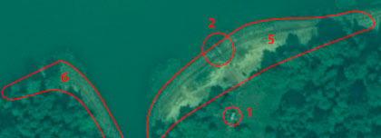
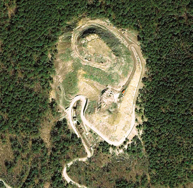
Then, the identified potential subsoil use objects were subjected to unsupervised classification using the ISODATA method to highlight active mining areas. Figure 2 shows the result of this procedure.
")
Fig. 2 General and active parts of the quarry (left and right respectively)
The identified quarries were supplemented with semantic information, entered into the attribute table. The following information was added:
- Interpretation confidence (100%, 75%, 50%, and 25%);
- Usage status (active, abandoned);
- Type (legal, illegal);
- Satellite image;
- Year;
- Area;
- Mineral (based on field verification);
- Depth (based on field verification).
A field verification route was then drawn up for the identified illegal subsoil use objects, consisting of 38 objects (Figure 3).

Fig. 3 Scheme of planned field survey routes
As a result of the field verification, 26 out of 38 objects were indeed illegal quarries. The interpretation accuracy was 69%, which is quite high.
Results
In total, 88 objects were identified, of which 57 are illegal subsoil use objects. 40 out of the 57 objects were verified in the field in 2018–2019, while the remaining 17 were not checked but are highly likely to be illegal quarries. A cartogram of the distribution of illegal quarries by municipal districts of the Republic of Mari El was created (Figure 4). Analyzing the resulting cartogram reveals the uneven distribution of objects across the territory of the republic. Most illegal quarries are located in the southeastern part of the region (Morkinsky, Kuzhenersky districts), while they are completely absent in the northwest (Kilemarsky district).

Fig. 4 Distribution of illegal quarries in the territory of Mari El
Illegal quarries are associated with treeless areas and outcrops of sandy/carbonate rocks close to the surface. The western and northern regions of the republic have high forest cover and low population density, so quarries are almost absent there. Quarries are often located in river floodplains where deeply lying sandy layers are exposed due to erosion.
As a result of the work, a GIS project was created. To view the results of the work, including photographs taken during field verification, a demonstration geoportal was additionally created (Figure 5).

Fig. 5 Fragment of the geoportal based on ArcGIS Online with field verification photographs
Conclusions
Based on the work results, it was established that ultra-high (sub-meter) spatial resolution images are better for identifying illegal quarries. Using images with a resolution of 2 meters or lower during interpretation will lead to the omission of small illegal objects. The most suitable images for the project's purposes are WorldView-2,WorldView-3, SuperView, KompSat-3, Pleiades, and Gaofen-2. Also, Resurs-P, Spot 6-7, Triplesat data performed well. It is possible to use images Kanopus-V and Gaofen-1. In any case, the higher the spatial and radiometric resolution of the original data, the better.
To highlight territories potentially suitable for subsoil use, it is recommended to conduct an analysis of the study area using medium-resolution images Sentinel-2, Landsat-8 and publicly available cartographic substrates (Yandex.Maps, Google Maps) at the initial stage. This will reduce costs for data acquisition and processing since water bodies, continuous forest areas, large industrial and settlement lands, and others can be excluded from the study.
You can order from us


Sat-Sun: Non-working days