your companion in the world
of geospatial solutions
Operation mode:
Mon-Fri: 10:00 - 18:00
Sat-Sun: Non-working days
Pollution determination using remote sensing data is the determination of the presence of new, usually uncharacteristic physical, chemical or biological agents introduced into the environment or arising in it.

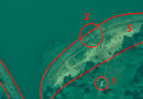
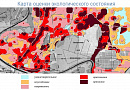
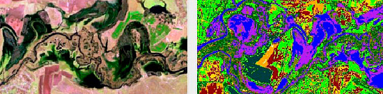
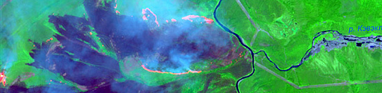
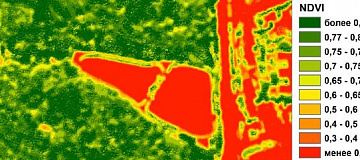
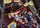
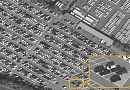
In other words, it is the process of detecting pollutants in the environment, their concentration, as well as identifying the nature of their origin.

According to the type of pollution is subdivided into anthropogenic and natural, and according to the scale there are local, regional and global pollution.

Why is pollution determination needed?

According to statistics, in 2015, 9 million people worldwide died as a result of pollution (source: Wikipedia). It becomes evident that the environmental condition of the planet is strictly monitored by global governments implementing new environmental programs (e.g., Decree of the President of the Russian Federation dated 19.04.2017 No. 176 "On the Strategy of Environmental Security of the Russian Federation for the Period up to 2025").

Organizations that violate environmental preservation face significant fines and other types of restrictions, including the possibility of their activities being prohibited.

Hence, the timely detection of harmful leaks is an essential measure, allowing not only the preservation of the environment but also safeguarding the budget of a particular enterprise. After all, it is technically easier and cheaper to eliminate hazardous substance leaks before the scale of the disaster becomes catastrophic.

Работник

Objectives of pollution determination using remote sensing data:

  • Evaluating the environmental situation in the region;
  • Identifying violations of subsoil use regulations;
  • Identifying emergency enterprises or special facilities;
  • Preventing and eliminating oil spills.

Tasks of pollution determination:

  • Detecting the presence of emissions of harmful substances into water bodies, as well as identifying objects potentially responsible for these emissions;
  • Identifying oil spills on both land and water surfaces;
  • Identifying unauthorized solid waste disposal sites and analyzing their historical state; in some cases, it is possible to determine the predominant type of stored material (plastic, metal, etc.);
  • Determining the extent of gas emissions into the atmosphere;
  • Identifying areas of forest stands in unsatisfactory conditions, allowing for emergency measures to save the forest.

Advantages of using remote sensing data:

  • Remote assessment of territory without the need for physical presence;
  • Possibility to study any territory, regardless of its configuration and geographical location;
  • Availability of archive materials worldwide since 1999;
  • Obtaining information about a large or linearly extensive study area in a short time, and with a suitable archived satellite image, the entire area can be captured in one image, significantly simplifying further processing;
  • Conducting surveys in various spectral channels, expanding the possibilities for subsequent analysis of the territory's condition;
  • Satellite images are significantly cheaper than UAV flights, especially for studying geographically remote areas;
  • Using UAVs or aircraft is essential for researching areas with prolonged and high cloudiness over the area of interest.

Prices for services

Consultation Free of charge
Ordering Satellite Images Starting from 300 USD per image, depending on the spatial resolution of the image and the requirements of the space imaging operators for the placed order.
Image Processing, Vectorization, Technical Report Calculated individually based on the area of the study site and the technical requirements of the task.

The price for detecting local sources of pollution is calculated individually and depends on: the area of the research site; the cost of suitable satellite imaging; the accuracy of georeferencing the obtained result; the required processing of satellite images, etc.

The cost of execution is calculated on an individual basis, taking into account a specific of task.

After receiving the task description, we calculate the cost and send you a commercial offer.

Period of execution

Coordination of terms of reference: from 1 to 5 days* Signing a contract and receiving an advance: from 1 to 5 days* Execution of the contract: from 8 days**
Total term: from 10 days*

* working days
** from the date of receipt of 100% advance payment

How to place an order:

  1. STEP №1: Leave an application on the website with the following information:
    • Location of the object of interest (coordinates, district name, region, shapefile, etc.);
    • Requirements for the imaging period (period for which archival data can be used or new imaging is required);
    • Determination of the required scale and accuracy;
    • Presumed or existing type of pollution;
    • Required final product format.
  2. STEP №2: Coordination of technical task and cost:
    • Satellite images are paid for separately;
    • The cost and list of services for detecting local sources of pollution are developed based on the requirements for the final result.
  3. STEP №3: Contract signing and commencement of work
    • Payment is only accepted through bank transfer. We begin executing the Contract immediately after receiving the advance payment.

We work with individuals, legal entities, individual entrepreneurs, government and municipal authorities, foreign customers, etc.

Need for consultation?

Fill the form and we will contact you

By clicking the «Send» button, you give your consent to the processing of your personal data, in accordance with Federal Law No. 152-FZ of July 27, 2006 «On Personal Data», on the conditions and for the purposes specified in the Consent to the processing of personal data.

Stages of service provision

Stage № 0 (Before Contract Signing):

  • Determination of the research area boundaries;
  • Definition of the research objective and type of presumed pollution;
  • Specification of data accuracy requirements.

RESULT: possibility (YES/NO) of providing the service.


Stage № 1 (Before Contract Signing):

  • Agreement with the customer on the type of space materials to be used;
  • Agreement with the customer on control points, ground control data for orthorectification of space images (if required);
  • Agreement on coordinate system, projection of the final product, output data format with the customer;
  • Agreement with the customer on technical report requirements (if required);
  • Final determination of labor and material costs, agreement on delivery schedules and costs.

RESULT: signed contract.


Stage № 2 (Contract Execution):

  1. Receiving 100% advance payment;
  2. Ordering remote sensing data materials;
  3. Incoming quality control of remote sensing data materials;
  4. Performing necessary processing of remote sensing data materials, orthorectification of images, and creating seamless orthomosaics (if required);
  5. Performing color correction and cloud cover correction of the resulting orthomosaic (if required);
  6. Interpretation of necessary objects, identification of pollution and potential sources, creation of vector GIS layers according to the universally accepted classifier and the classifier provided by the customer;
  7. Adding necessary semantic information;
  8. Exporting data into different coordinate systems and projections;
  9. Analysis of the obtained information, compilation of a consolidated technical report (if required).

RESULT:

Raster base in the form of orthorectified satellite images, vector GIS layers, and a technical report (if required) in accordance with the customer's requirements.

The result of the provision of services

Ready-to-load raster base (satellite images) for various GIS systems, as well as vector layers and a comprehensive analytical report (if required).


Requirements for source data:

  • Accurate location of the area of interest (coordinates, district name, region, shapefile, etc.);
  • Requirements for the period of obtaining satellite images (or the period of conducting a new survey);
  • Requirements for result accuracy;
  • Requirements for the content of the technical report;
  • Other relevant information available.

If it is not possible to provide the specified information, please provide details about the intended use of the remote sensing data. The specialists of "GEO INNOTER LLC" will analyze the requirements and propose the optimal solution to address the problem.

Related services

Orthoimagery (Orthorectification)
Find out the price
Remote sensing imagery Interpretation & spectral analysis
Find out the price
Digital Topographic Maps
Find out the price
Thematic mapping
Find out the price
MSW landfill sites Monitoring
Find out the price
Forest Health Monitoring
Find out the price
Создание ортофотопланов
Find out the price
Создание и обновление топографических карт
Find out the price
Составление тематических и специальных карт, планов
Find out the price
Дешифрирование данных дистанционного зондирования Земли (ДЗЗ)
Find out the price
Лесопатологический мониторинг
Find out the price
Мониторинг мест складирования ТБО
Find out the price
Zazulyak Evgeny Leonidovich
The material was checked by an expert
Zazulyak Evgeny Leonidovich
Engineer, 28 years of experience, Education - Moscow Topographic Polytechnic Technical School, St. Petersburg Higher Military Topographic Command School named after Army General A.I. Antonov, Military Engineering University named after V.V. Kuibyshev. Kuibyshev Military Engineering University.

Customers

Роснефть
Газпром
Газпром нефть
Лукойл
Транснефть

FAQ

Yes. This requires spectral analysis of space images using the SWIR infrared channel. At the moment satellites capable of SWIR data acquisition have been put into orbit and are successfully operating.
Yes. The accuracy of this metric will be influenced by the spatial resolution of the image used, as well as the degree and accuracy of its processing. It should also be taken into account that any oil slick on the surface of a water body changes its shape rather quickly due to the natural process - constant movement of water mass.
Yes, remote sensing can be used to detect pollution. Remote sensing uses sensors such as satellites, aircraft, or drones to capture images and data from the Earth's surface. By analyzing these images and data, scientists and environmentalists can detect various types of pollution including air pollution, water pollution, and soil pollution. For example, remote sensing can detect pollutants such as oil spills, chemical releases, or changes in vegetation health that may be indicative of pollution. This information can then be used to monitor and mitigate pollution, as well as to inform environmental policy and decisions.
Remote sensing plays a crucial role in monitoring and managing various aspects of pollution. Some of the key applications of remote sensing in pollution include: Air Quality Monitoring: Remote sensing can be used to monitor air pollutants such as particulate matter (PM), nitrogen dioxide (NO2), sulfur dioxide (SO2), and ozone (O3). Satellite sensors can provide spatial and temporal data on air quality over large areas. Water Quality Assessment: Remote sensing is employed to assess water quality parameters such as turbidity, chlorophyll-a concentration, and harmful algal blooms. It helps in identifying polluted water bodies and monitoring changes over time. Oil Spill Detection: Satellite and aerial imagery can be used to detect and monitor oil spills in oceans and water bodies. Remote sensing helps in assessing the extent of the spill, tracking its movement, and facilitating timely response measures. Land and Soil Pollution Monitoring: Remote sensing techniques can be applied to detect changes in land cover and land use patterns, which may indicate pollution sources. It can also be used to assess soil contamination and degradation. Urban Heat Island (UHI) Studies: Remote sensing helps in studying the heat island effect in urban areas, where temperatures are higher than in surrounding rural areas. UHI can be linked to pollution, and remote sensing provides valuable data for understanding and mitigating its impact. Deforestation and Biomass Burning Monitoring: Remote sensing helps in monitoring deforestation and biomass burning, which release pollutants into the atmosphere. It aids in assessing the impact on air quality and ecosystems. Industrial Emissions Monitoring: Remote sensing allows for the monitoring of industrial facilities and their emissions. Satellite and aerial imagery can be used to identify pollution sources, track emissions, and assess compliance with environmental regulations. Natural Disaster Impact Assessment: Remote sensing helps assess the environmental impact of natural disasters such as wildfires, volcanic eruptions, and earthquakes, which can lead to pollution and environmental degradation. Mapping Environmental Changes: Remote sensing data can be used to map changes in the environment over time, enabling researchers and policymakers to identify trends related to pollution and take appropriate corrective measures. By leveraging remote sensing technologies, researchers and authorities can obtain comprehensive and timely information about pollution, enabling better decision-making and effective environmental management.
Remote sensing aids pollution management by providing accurate and timely data for monitoring and implementing effective solutions.
Pollution detection through remote sensing involves the use of specialized sensors and satellite imagery to identify and quantify various pollutants. Here are some key ways in which remote sensing is employed to detect pollution: Spectral Analysis: Remote sensing instruments can capture data across different wavelengths of the electromagnetic spectrum. Each type of pollutant has a unique spectral signature. Analyzing the spectral response helps identify and quantify pollutants such as oil, chemicals, or particulate matter. Gas Detection: Sensors on satellites can detect and measure concentrations of gases in the atmosphere. For example, they can identify elevated levels of pollutants like sulfur dioxide (SO2), nitrogen dioxide (NO2), methane (CH4), and carbon monoxide (CO), providing insights into air quality. Infrared Imaging: Infrared sensors are effective in detecting thermal pollution and capturing temperature variations. They can identify heated effluents or discharges into water bodies, indicating potential sources of pollution. Multispectral Imaging: Multispectral sensors capture data in multiple bands, allowing for the differentiation of land cover types and the identification of changes. This capability is useful in monitoring areas affected by land pollution, deforestation, or illegal dumping. Chlorophyll Detection: Chlorophyll-a concentration in water bodies is an indicator of nutrient pollution. Remote sensing can detect chlorophyll levels, helping assess eutrophication and algal blooms that result from excessive nutrient input. Oil Spill Monitoring: Remote sensing plays a crucial role in detecting and monitoring oil spills in oceans and other water bodies. Satellite imagery can capture the extent and location of spills, enabling rapid response and containment efforts. Change Detection: Regular monitoring of an area over time allows for the detection of changes in land use, vegetation, and water quality. Sudden or unexpected changes may indicate pollution events or environmental degradation. Vegetation Stress Detection: Pollutants can cause stress to vegetation. Remote sensing can detect changes in vegetation health by analyzing spectral reflectance, helping identify areas affected by pollution or contamination. Urban Heat Island Effect: In urban areas, remote sensing helps detect the heat island effect, where temperatures are higher than in surrounding rural areas. This can be an indirect indicator of air pollution and increased energy consumption. Data Integration and Modeling: Remote sensing data is often integrated into environmental models, allowing for the simulation and prediction of pollution dispersion, helping authorities understand the potential impact of pollutants. By utilizing these techniques, remote sensing contributes significantly to pollution detection, enabling timely response and effective environmental management.
Various types of sensors are used to monitor different pollutants and environmental parameters. The choice of sensor depends on the specific type of pollution being measured. Here are some common types of sensors used to monitor pollution: Gas Sensors: Gas sensors are designed to detect and measure concentrations of specific gases in the air. Examples include sensors for detecting pollutants like sulfur dioxide (SO2), nitrogen dioxide (NO2), carbon monoxide (CO), and methane (CH4). Particulate Matter (PM) Sensors: These sensors measure the concentration of particulate matter in the air, including fine particles (PM2.5) and coarse particles (PM10). They are crucial for assessing air quality and respiratory health. Weather Sensors: Instruments such as anemometers, barometers, and hygrometers are used to monitor meteorological conditions. Weather data is important for understanding how pollutants disperse in the atmosphere. Infrared Sensors: Infrared sensors can be used to measure thermal radiation and detect temperature variations. They are useful for identifying sources of thermal pollution and monitoring changes in surface temperatures. Chlorophyll Sensors: Sensors that measure chlorophyll levels in water bodies are used to assess nutrient pollution and the presence of algal blooms, which can impact water quality. Lidar (Light Detection and Ranging): Lidar systems use laser technology to measure distances and map topography. They are valuable for monitoring air quality, atmospheric aerosols, and identifying sources of pollution. Fluorescence Sensors: Fluorescence sensors can detect organic compounds and pollutants in water by measuring the fluorescence emitted when certain substances are exposed to specific wavelengths of light. Radiation Sensors: Radiation sensors measure different types of radiation, including ionizing radiation. They are used to monitor environmental radioactivity and detect potential sources of nuclear pollution. Spectral Sensors: Spectral sensors capture data across various wavelengths of the electromagnetic spectrum. They are employed for analyzing the spectral signatures of different substances, aiding in the identification of pollutants. Photometers: Photometers measure the intensity of light, and they can be used to assess water quality by measuring turbidity, which is an indicator of suspended particles in water. The combination of these sensors, often integrated into monitoring systems, allows for comprehensive environmental monitoring and the detection of various types of pollution. Additionally, remote sensing technologies, such as those on satellites and drones, often carry multiple sensors to capture a broad range of environmental data.
1. Government and Non-Profit Environmental Protection Organizations:
Environmental protection authorities and other government agencies can use remotely sensed data to monitor and assess pollution in different regions. These data help develop environmental management strategies and take measures to reduce pollution.
2. Scientific Research Organizations:

Scientists and research organizations use remotely sensed data to study the effects of pollution on ecosystems, climate, and biodiversity. These organizations can conduct long-term studies and analyze changes in the environment.

3.International Organizations:
Organizations such as the World Meteorological Organization (WMO) and the United Nations Environment Programme (UNEP) can use remotely sensed data for international monitoring and cooperation in environmental management.

4. Geological Services and Institutes:
Geological research organizations can use remotely sensed data to detect soil contamination, monitor changes in the landscape, and assess impacts on geological formations.

5. Community Organizations and Activist Groups:
Non-profit organizations and environmental activist groups can use remotely sensed data to monitor industrial operations, detect illegal emissions, and advocate for public interest in environmental issues.

6. Environmental Consulting Firms:
Commercial firms specializing in environmental consulting can use remotely sensed data to provide clients with environmental information, especially as part of environmental assessments of projects.

7. City Governments and Municipalities:
Local authorities can use remote sensing data to monitor pollution in urban and peri-urban areas. This helps in developing sustainable development plans and managing areas at high risk of pollution.

The use of remotely sensed data in solving pollution problems requires cooperation between different organizations, including government, academia, and commercial entities, for effective monitoring and management of the environment.

Licenses

License for implementation of geodetic and cartographic activities (page 1)
License for implementation of geodetic and cartographic activities (page 2)
Application for the license for implementation of geodetic and cartographic activities
ISO 9001:2015 Certificate of Conformity №СДС.ФР.СМ.00813.19 (page 1)
ISO 9001:2015 Certificate of Conformity №СДС.ФР.СМ.00813.19 (page 2)

Warranty

It is optimal to indicate the profile RF and international documents regulating the subject area under consideration.

We guarantee 100% quality of services. Cooperating with GEO Innoter specialists, you eliminate risks and losses!

The presence of qualified personnel with extensive experience in working with specialized software makes it possible to ensure timely and high-quality performance of work!

Our partners

Request a call back
Back to page top