your companion in the world
of geospatial solutions
Operation mode:
Mon-Fri: 10:00 - 18:00
Sat-Sun: Non-working days

Oil spills are a global problem for humanity that has a negative impact on the environment. Pollution of the Earth's surface can occur at any stage of oil extraction, transportation, and processing. The results of oil and/or oil product spills are usually visible immediately, but toxic consequences often manifest on land over many years. This happens because not only surface waters but also groundwater can be affected by pollution. Ultimately, a delayed-action bomb is created, which leads to catastrophic outcomes. Timely detection and elimination of the consequences of oil spills reduce irreparable damage to the environment.

Fast, accurate, and remote spatial assessment of oil pollution is crucial for implementing countermeasures that prevent negative consequences.

In 2019, there were 17,000+ accidents with oil spills at fuel and energy complex facilities in Russia, with 10,500 of them occurring in oil pipelines.

GEO INNOTER LTD performs monitoring of oil spills using satellite imagery in accordance with Federal environmental protection legislation to identify contaminated areas, determine the cause of pollution, and forecast the development of the polluted area.

The Purpose of Onshore oil spill monitoring

Oil spills destroy any aquatic ecosystem and hinder plant growth on land, as the oil film prevents the soil from absorbing water. Consequently, water contaminated with oil cannot be used for irrigating crops and pastures. Prompt operations to prevent the spread of spills directly impact the rapid recovery of the soil to a productive state.

Oil spills in cities and towns can have adverse effects on human health, making it crucial to act swiftly. For people, an oil spill can threaten the closure of public water supply systems. Acting quickly not only reduces the impact of contamination on human health but also restores the city or urban area to a safe environment. It's worth noting that urban areas also include parks and forested areas, which must be considered in the remediation plan.

Monitoring of oil pollution is carried out in accordance with Federal environmental protection legislation to identify contaminated areas, determine the causes of pollution, and implement measures to mitigate the consequences of oil spills.


Работник
monitoring.png

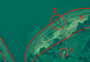
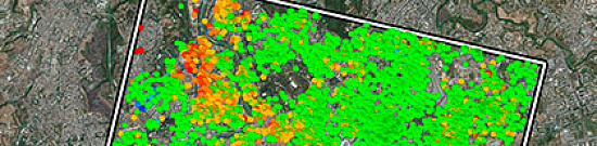
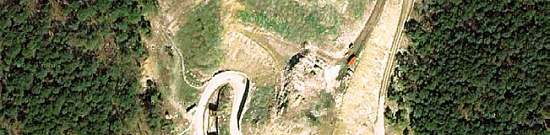
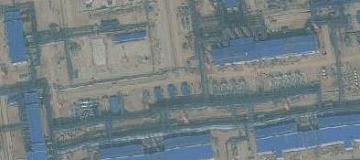
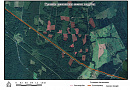
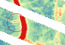
Ris. Detection of contaminated lands in oil production areas.

Monitoring of oil spills on land is essential for oil-producing companies and the structures of the Ministry of Natural Resources and Environment of Russia to maintain a stable environmental situation and prevent violations in the field of nature management.

Goals and Objectives of Onshore oil spill monitoring

The main goal of onshore oil spill monitorings is to identify contaminated areas and determine the causes of their occurrence.
In particular, monitoring of oil spills accomplishes the following tasks:

  • Detection of oil spills within licensed areas.
  • Localization of contaminated land areas.
  • Assessment of the rate of reclamation of areas affected by oil spills.
  • Control of compliance with regulations for the reclamation of areas.
  • Assessment of the environmental consequences of oil spills.
  • Comprehensive assessment of natural and man-made conditions of the territory.
  • Identification of facts of accidental oil spills.
  • Provision of information support for the prevention and elimination of accidental oil and oil product spills.
  • Research, analysis, and assessment of the environmental consequences of oil spills.

Land and water object inventory also includes:

  • Detection of oil spills within licensed areas.
  • Identification of the localization of contaminated land areas.
  • Assessment of the rate of reclamation of areas after oil spills.
  • Control of compliance with regulations for the reclamation of areas.
  • Assessment of the environmental consequences of oil spills.
  • Confirmation of the successful completion of reclamation measures.

Environmental inventory and documentation of lands are carried out in accordance with Federal environmental protection legislation to identify contaminated areas, unregistered waste disposal sites, and land plots where waste negatively affects the natural environment.

monitoring2.png

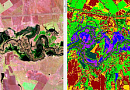
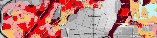
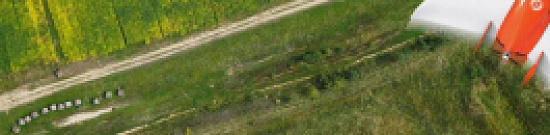
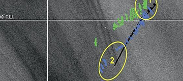
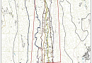
Ris. Example of identifying areas with different degrees of contamination.


Advantages of Using Remote Sensing Data

Modern remote sensing tools provide optical (visible), multispectral, and radar images with ultra-high resolution and high operational efficiency, allowing for the following:

  • Rapid localization and assessment of the scale of anthropogenic impact, including oil spills.
  • Evaluation of the degree of impact of oil spills on ecosystems.
  • Minimization of fieldwork in remote and challenging regions with harsh climates, high swampiness, and underdeveloped infrastructure.
  • Significant reduction in project timelines due to data's comprehensive coverage and rapid acquisition.

On local and regional levels, unmanned aerial vehicles (UAVs) have significant advantages over fieldwork:

  • Continuous monitoring of hazardous oil infrastructure objects.
  • High-quality imaging, including video streaming.
  • Periodic monitoring of pipelines, up to hundreds of kilometers.
  • Rapid detection of oil spills.
  • Assessment of the technical condition of pipelines, detecting damage, corrosion, and ruptures.
  • Coordination of actions of ground teams in case of emergencies.

The advantages of using remote sensing lie in the technical capabilities of satellite imaging:

  • Satellite monitoring of oil spills identifies and clearly delineates polluted areas thanks to the use of spectral channels.
  • InfraRed (IR) spectral imaging offers some potential as a tool for detecting oil spills. During the day, oil absorbs light and emits it as thermal energy at temperatures 3–8 K higher than the ambient temperature.
  • Laser fluorosensors are useful tools due to their ability to identify oil against the background of water, soil, weeds, ice, and snow. They are the only sensors capable of positively differentiating oil on most backgrounds. Laser fluorosensors allow precise identification and differentiation of oil types.
  • Radar detects oil on water only when the oil suppresses capillary waves on the water surface under conditions of weak or moderate waves/wind. Radar offers the only potential for large-scale search and remote sensing during the day/night and in inclement weather. Satellite radar sensors are useful for mapping large spills, although their revisit frequency and lower spatial resolution limit their use for smaller spills.

Prices for services

Consultation Free of charge
Image acquisition, preliminary analysis Free of charge
Ordering radar and optical images

The cost of remote sensing materials is calculated individually for each order and may vary based on:

  • Use of free satellite images
  • and/or use of commercial satellite images
Cost of mapping natural and anthropogenic objects based on image interpretation, field surveys, and laboratory research  Calculated individually
Execution time
From 20 working days (depends on the volume, complexity, and availability of archival images)

The price depends on the number of processed images and the scope of work and is calculated individually for each customer.

After receiving a description of the task, we will calculate the cost and send you a commercial offer.


The cost of execution is calculated on an individual basis, taking into account a specific of task.

After receiving the task description, we calculate the cost and send you a commercial offer.

Period of execution

The completion time for the work is 20 working days from the date of receiving the advance payment, and it is calculated individually for each customer.

The timeframe for completing the work depends on the following factors:

  • Total area of the area of interest;
  • Availability of archival remote sensing materials and the need for new imaging;
  • Requirements for remote sensing materials and the final product;
  • Complexity of the work.

How to place an order:

To order our services, you can follow these steps:
Step 1: Submit a request on our website, providing the following information:
  • Location of the area of interest (coordinates, district, region, shapefile, etc.);
  • Your questions and specific requirements;
  • The time period for which you need the analysis/monitoring.
Step 2: We will coordinate the technical requirements and the cost with you, as the price is determined for each specific case. The satellite images will be priced separately.

Step 3: Once we have agreed on the technical details and cost, we will proceed with signing the contract and starting the work. The completion time is 20 working days from the date of receiving a 100% advance payment for the satellite imagery. Payments are accepted only through non-cash transactions. The remaining payment will be made after the completion of the work.

We serve both individuals and legal entities, individual entrepreneurs, government and municipal authorities, foreign customers, and more.

You can also submit your request via email: innoter@innoter.com or contact us by phone: +7 495 245-04-24, or through the online chat on our website.

Need for consultation?

Fill the form and we will contact you

By clicking the «Send» button, you give your consent to the processing of your personal data, in accordance with Federal Law No. 152-FZ of July 27, 2006 «On Personal Data», on the conditions and for the purposes specified in the Consent to the processing of personal data.

Stages of service provision

Here is an outline of the different stages involved in the process before and during the contract:
Stage 0 (Pre-contract):
  • Determining the dates and parameters of the desired satellite imagery (imaging period, type of imaging).
  • Checking the availability of satellite imagery materials for the area of interest.
  • Verifying selected images to meet the customer's requirements.
Result: Assessment of the possibility (YES/NO) of providing the service.

Stage 1 (Pre-contract):
  • Coordination with the customer regarding the data from archival satellite imagery.
  • Agreement with the customer on the satellite system for ordering new satellite imagery.
  • Final determination of labor and material costs, agreement on delivery timeframes, and pricing.
Result: Signed contract. Stage 2 (Contract execution):
  • Receipt of 100% advance payment.
  • Conducting multispectral high-resolution satellite imaging within the boundaries of the licensed areas and interfield territories, during the specified period indicated by the customer in the order for satellite imagery materials.
  • Incoming quality control of satellite images.
  • Photogrammetric processing of satellite imagery materials, including creating a digital elevation model (DEM), obtaining synthesized images, orthotransforming imaging materials, and creating synthesized orthophotomosaics.
  • Field sampling, chemical and analytical control, and quantitative chemical analysis.
  • Mapping of natural and anthropogenic objects based on image interpretation, field surveys, laboratory research, and analysis of customer data.
  • Initial processing of radar images to eliminate noise and refine the geographic location of objects.
  • Preparation of an analytical report, including statistical, analytical, and technical information about the work performed, and a General Register of polluted lands.
  • Sending the report and other documents, as specified in the contract, to the customer electronically in agreed formats according to the Technical Assignment.
These stages outline the step-by-step process involved in the project, from pre-contract assessments and agreements to the execution and delivery of the final results.

The result of the provision of services

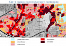
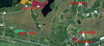
The following cartographic and attribute GIS layers of classified data are created:
  • Contaminated land parcels - 1 layer, with an attribute table indicating the types and degree of contamination.
  • Oil-contaminated water bodies - 1 layer with an attribute table specifying the types of water body contamination.
  • Locations of temporary waste storage - 1 layer with an attribute table indicating the types and status (rehabilitated or unrehabilitated).
  • Sampling points - 1 layer, with an attribute table indicating the type of sample (soil, ground, sediment).
In the conclusion, a final analytical report is prepared, reflecting statistical, analytical, and technical information about the work performed, as well as a general register of polluted and disturbed lands or contaminated water bodies.

Requirements for Source Data

Precise coordinates of the area of interest, requirements for satellite and aerial imagery materials (resolution on the ground, type of imagery, imaging period).

If it is not possible to provide the specified information, please provide information about the purpose of using the satellite imagery materials, and specialists from "GEO INNOTER" will analyze the requirements and suggest an optimal solution to the problem.

Related services

Land displacement monitoring (InSAR Ground Deformation Monitoring)
Find out the price
Aerial & UAV imagery
Find out the price
Infrastructure Change Detection (PIPELINE Monitoring)
Find out the price
Thematic mapping
Thematic mapping
Find out the price
Environmental Monitoring
Find out the price
MSW landfill sites Monitoring
Find out the price
Мониторинг нарушения охранных зон. Дистанционный контроль соблюдения минимальных расстояний с помощью ДЗЗ.
Find out the price
Составление тематических и специальных карт, планов
Find out the price
Мониторинг мест складирования ТБО
Find out the price
Экологический мониторинг (экомониторинг)
Find out the price
Мониторинг смещений и деформации земной поверхности (геодинамический мониторинг)
Find out the price
Аэрофотосъемка (АФС / БПЛА)
Find out the price
Zazulyak Evgeny Leonidovich
The material was checked by an expert
Zazulyak Evgeny Leonidovich
Engineer, 28 years of experience, Education - Moscow Topographic Polytechnic Technical School, St. Petersburg Higher Military Topographic Command School named after Army General A.I. Antonov, Military Engineering University named after V.V. Kuibyshev. Kuibyshev Military Engineering University.

Customers

Rosneft
Gazprom
Gazprom neft
Lukoil
Transneft

FAQ

To assess the state of an oil spill, the following set of data is required:

  • Possible location of the oil spill, environmental information (coordinates, district name, region, SHP file, etc.);
  • Requirements for the time period (period for which archival data can be used or the need for new imagery);
  • Whether monitoring has been conducted in this area previously.
The terms of monitoring works execution depend on the area, requirements to the survey parameters. The minimum execution time is from 20 working days.
100% prepayment on the invoice for RS materials after signing the contract, the rest of the payment after execution.
  • Identifying violations of environmental protection requirements established by the legislation of the Russian Federation;
  • Establishing the reasons that caused environmental pollution;
  • Determining the damage caused as a result of environmental pollution.
In order to develop the observation system for detection of oil (oil product) spills in the Arctic zone of the Russian Federation characterized by extreme natural and climatic conditions and low population density, it is advisable to preferentially use methods of remote sensing of the Earth's surface (aerial and space imagery methods).
  • Appeals and statements from citizens, including individual entrepreneurs, legal entities, information from government authorities, local self-government bodies, and mass media about incidents posing a threat to the life, health of citizens, harm to animals, plants, and the environment, as well as incidents causing harm to life, health of citizens, harm to animals, plants, and the environment;
  • Information about natural and man-made emergencies and disasters;
  • Results of public control in the field of environmental protection (public environmental control);
  • Data from Earth remote sensing;
  • Other information in accordance with the legislation of the Russian Federation.

The monitoring organization consists of three stages and includes:

  • Preparatory work (developing a preliminary system for organizing monitoring in the region, methods of conducting it);
  • Preliminary survey of the spill area (ground-based methods may be used);
  • Planning the organization of the monitoring system.
Remote sensing data contributes to onshore oil spill monitoring by capturing changes in land cover, detecting alterations in soil reflectance, and identifying anomalous patterns. Specific features indicating the presence of oil contamination include dark patches in optical imagery, changes in thermal infrared signatures, and shifts in vegetation health observed through multispectral sensors.
Common remote sensing technologies for onshore oil spill monitoring include optical sensors, thermal infrared sensors, and hyperspectral sensors. Optical sensors capture visual information, thermal infrared sensors detect temperature variations associated with oil, and hyperspectral sensors identify specific spectral signatures of contaminated areas. Integrating these technologies provides a comprehensive understanding of the oil spill's extent and impact.
The temporal aspect of satellite imagery contributes to onshore oil spill monitoring by allowing for the assessment of changes over time. Time-series analysis facilitates the tracking of the spill's progression, the identification of areas affected at different stages, and the evaluation of the environmental impact. This information is crucial for planning response efforts and assessing the effectiveness of cleanup measures.
Remote sensing technology assists in quantifying the volume of oil spilled onshore by providing data on the affected area's extent and thickness of the oil layer. This information is crucial for response and recovery planning, as it helps authorities allocate resources, estimate environmental damage, and implement effective cleanup strategies based on the scale of the spill.
Integrating remote sensing data with GIS technology enhances onshore oil spill monitoring by providing a spatial context for analysis. This integration allows for the creation of detailed maps, visualization of impacted areas, and spatial analysis for decision-making. GIS technology facilitates coordination among response teams, enables efficient resource allocation, and supports evidence-based decision-making throughout the onshore oil spill monitoring and recovery process.

Licenses

License for implementation of geodetic and cartographic activities (page 1)
License for implementation of geodetic and cartographic activities (page 2)
Application for the license for implementation of geodetic and cartographic activities
ISO 9001:2015 Certificate of Conformity №СДС.ФР.СМ.00813.19 (page 1)
ISO 9001:2015 Certificate of Conformity №СДС.ФР.СМ.00813.19 (page 2)

Warranty

Monitoring of oil pollution is carried out in accordance with Federal legislation on environmental protection to identify contaminated water areas, determine the causes of pollution, and implement measures to eliminate pollution:

  • Resolution of the Government of the Russian Federation dated December 31, 2020, No. 2451 "On the Approval of the Rules for the Organization of Measures to Prevent and Eliminate Oil and Oil Product Spills on the Territory of the Russian Federation, except for the internal sea waters of the Russian Federation and the territorial sea of the Russian Federation, as well as on the Recognition of Some Acts of the Government of the Russian Federation as Invalid."
  • Federal Law No. 207-FZ dated July 13, 2020.
  • The obligation to develop a plan for the prevention and elimination of oil and oil product spills (hereinafter referred to as PPLEOP) is introduced for activities related to the extraction, production, transportation, storage, and sale of hydrocarbon raw materials and products on the territory of the Russian Federation (paragraph 4 of the amended Article 46 of Law No. 7-FZ).
  • The Methodology for the detection of oil spills was approved by the Order of the Ministry of Natural Resources and Environment of the Russian Federation dated December 20, 2017, No. 696. Link to the methodology.
  • We guarantee 100% quality in the provision of our services. By collaborating with GEO Innoter specialists, you eliminate risks and losses!

The presence of qualified personnel with extensive experience in working with specialized software allows us to guarantee timely and high-quality completion of tasks!

Advantages of cooperating with GEO INNOTER

  • Many years of experience in the field.
  • Direct distribution agreements with satellite imagery operators.
  • Experience in executing projects of any complexity using both aerial imagery and satellite imagery.
  • Availability of modern software for processing remote sensing data.
  • Robust server capacities for data processing.
  • A team of highly skilled specialists in cartography and photogrammetry.

Our partners

Request a call back
Back to page top