Laser or Lidar scanning is a technology for obtaining and processing information using active optical systems (lasers - lidars) that utilize the phenomenon of light reflection from objects to conduct high-precision measurements of X, Y, Z coordinates.
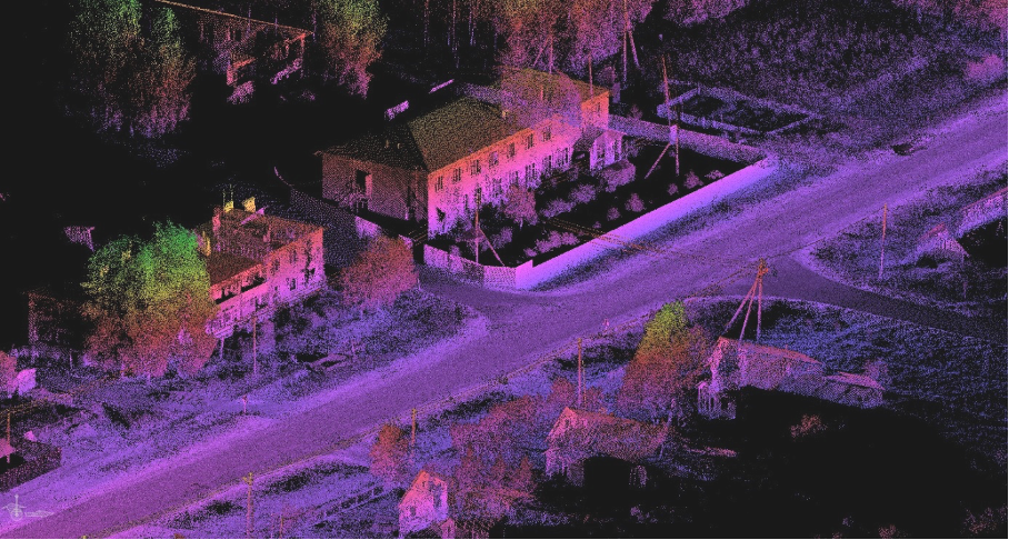
LIDAR Aerial Survey is a type of survey that allows creating a digital 3D model of an object or building by representing it as a set of points with high-precision spatial coordinates. This technology employs laser scanners (lidars) that measure the coordinates of surface points of the object at high speed (up to several tens of thousands of points per second). The obtained set of points is called a "point cloud." For each point in the laser scan, X, Y, Z coordinates, and the intensity value of the reflected signal are determined. The "point cloud" is colored based on the intensity of the reflected signal, resulting in a 3D digital photo-like representation after scanning. Nearly all modern laser scanner models (lidars) have an integrated video or photo camera, which allows coloring the point cloud with real colors.
LIDAR aerial survey can be divided into aerial, terrestrial, and mobile scanning methods.
Uses of Laser Scanning (Lidar aerial survey):
Aerial Laser Scanning (ALS) is a technology that involves high-frequency laser beam irradiation of the Earth's surface, including ground objects, from any aerial vehicle (airplane, helicopter, gyroplane, UAV) to obtain a "point cloud" of coordinates. ALS is used to create topographic plans of linear and planar objects in scales of 1:500 to 1:5000, digital terrain models (DTM), and digital elevation models (DEM). Usually, ALS is accompanied by simultaneous aerial imagery with a resolution of 5-15cm in the visible and near-infrared ranges. It is mainly used for engineering surveys of infrastructure objects, urban planning, volume calculation of moved earth (quarries, waste disposal sites, etc.), and monitoring various types of objects.
Terrestrial Laser Scanning (TLS) is used to obtain detailed 3D models of objects, create facade plans, and large-scale topographic plans from 1:50 to 1:500. Terrestrial laser scanners allow capturing objects as small as 0.5cm with an accuracy of up to 0.5mm, enabling the determination of spatial coordinates of object points. TLS can be performed at any time of the day. Productivity can reach up to 4000m2 for facade scans at a scale of 1:50 and up to 20 hectares for topographic plans at a scale of 1:500. TLS is carried out from ground-level objects or from a tripod in a discrete mode (with device repositioning). This laser scanning method is successfully used in closed spaces and environments (tunnels, caves, etc.) and is ideal for complex structures and interior scans.

You can order from us
Prices for services
| Consultation | Free |
|---|---|
| Preliminary analysis | Free |
| Order of scans |
From 3300 USD* |
| Execution time | From 20 business days (depending on the area of the surveyed territory, survey requirements, time for obtaining flight permission (for ALS), and quality control review, as well as requirements for the final product. |
* - The cost of laser scanning works is discussed individually for each project and depends on the specifics, goals, objectives, deadlines, and requirements for the final results.
The cost of execution is calculated on an individual basis, taking into account a specific of task.
After receiving the task description, we calculate the cost and send you a commercial offer.
Period of execution
The execution time of the works depends on:
- Execution time - from 20 (twenty) business days;
- The execution time of the works depends on the total area of the survey, requirements for the final result, time for obtaining flight permission (for ALS), and quality control review by the military district headquarters, the distance of the object from the location of the performer, and is calculated individually for each Client.
How to place an order:
Need for consultation?
Fill the form and we will contact you
Stages of service provision
The result of the provision of services
The final product based on the laser scanning materials, according to the Client's Technical Task, includes the following:
- Created (updated) topographic plans with scales of 1:500 to 1:5000.
- Report on object monitoring.
- High-precision digital terrain models and digital elevation models.
- Orthophotoplans in the required survey ranges (only for ALS), complementing the laser scanning according to the Client's Technical Task;
- Perspective aerial imagery (only for ALS), according to the Client's Technical Task.
- Laser scanning materials (point cloud) in a format convenient for the Client.
- Description of objects and territories during laser scanning.
Company GEO INNOTER provides the Client, who requested laser scanning services, with the finished products according to the Technical Task on electronic media or via the Internet through FTP servers.
Requirements for Source Data
Accurate coordinates of the area of interest, technical requirements for laser scanning materials (point cloud density, type of survey (ALS, UAV-LiDAR), survey period, requirements for the final result).
If it is not possible to provide the specified information, provide details about the intended use of the laser scanning results, and the specialists of GEO INNOTER will analyze the requirements and propose an optimal solution to the problem.
Related services


Customers
FAQ
- The task that needs to be solved using LiDAR survey;
- Area of interest (location / coordinates of the object in any convenient format, and the area of the object);
- Date or time interval for which the survey can be conducted;
- Requirements for the survey (type of survey, point cloud density, requirements for the final product, and delivery timeline).
Licenses
Warranty
Our company guarantees 100% quality of services. Cooperating with GEO Innoter specialists, you exclude risks and losses!The availability of qualified personnel with extensive experience in working with specialized software allows us to ensure timely and quality work!


