your companion in the world
of geospatial solutions
Operation mode:
Mon-Fri: 10:00 - 18:00
Sat-Sun: Non-working days

Forest Health Monitoring

Forest health monitoring is a system of observations aimed at assessing the condition of forests and forest plantations, identifying disturbances in their stability, areas affected by pests, disease foci, and other natural and anthropogenic environmental factors, as well as tracking the dynamics of these processes.

Forest health monitoring surveys involve activities to assess the state of forests and identify areas affected by pests and diseases. The use of satellite imagery in forest pathology surveys significantly reduces costs.

Purposes of Forest health monitoring

Forest health monitoring ensures early detection of unfavorable conditions in forest stands, evaluation, and prediction of the situation for timely decision-making regarding effective nature conservation and forest protection measures.

Forest health monitoring helps prevent and reduce the damage caused by pests and diseases to the forest.

Conducting forest pathology surveys is a relatively costly and labor-intensive process. However, failure or delayed action in detecting diseases and pests can lead to catastrophic financial and ecological consequences. Adequate preparation for forest pathology surveys not only reduces financial and time costs but also allows for an overview of hard-to-reach areas where field surveys are practically impossible.

The process of forest pathology surveys involves:

  1. Identifying the causes of damage or death of forest stands.
  2. Determining the location and boundaries of damaged forest stands.
  3. Evaluating the current sanitary and pathological condition of forest stands.
  4. Identifying measures to prevent the spread of harmful organisms.
  5. Detecting hazardous trees.

Satelitte images make it easy to detect destructive changes in the condition of tree canopies through multispectral analysis. Progressing dynamics of localized drying indicates the development of tree diseases or the impact of pests. Timely detection of such changes allows for immediate action to eliminate them.

For analysis, high-resolution images are usually used. The use of satellite imagery not only allows for assessing the state of vegetation at the current time but also enables tracking changes based on archived images from previous months and years. This provides information on the time of occurrence of outbreaks, allowing for the forecasting of further development of pest populations.

Работник

Objective of Forest health monitoring :

  • Timely observation and detection of pathological conditions in forests and forest areas, rapid identification and diagnosis of pathological processes in forests;
  • Prediction of the development of harmful species for forests;
  • Forecast of mass weakening and drying of forest stands;
  • Impact of dangerous pests on forest conditions;
  • Degree of contamination of specific forest areas;
  • Analysis of unfavorable indicators;
  • Acquiring, collecting, and detailed analysis of information about pathological changes in forest stands to justify decisions on the necessity of forest protection or other forestry work.

Tasks of Forest health monitoring :

  • Continuous monitoring of the dynamics of the state and stability of forest stands, changes in disease development, population size, and condition of harmful insects, and other forest damages;
  • Systematic summary and analysis of the results of forest pathology monitoring, compiling forest pathology overviews within specified timeframes;
  • Developing forecasts for the forest pathology situation, identifying expected threats to forest stands or forests, and assessing potential ecological and economic damage;
  • Justifying and making rational decisions to protect forests from damage, maintain their stability and productivity;
  • Ongoing monitoring of the population size (reproduction) and condition of harmful insects and other forest damages.

Advantages of Remote Sensing (RS) Data in Forest Pathology Monitoring Compared to Ground Surveys:

Remote sensing-based forest health monitoring using spaceborne systems has several advantages compared to ground surveys:

  • Rapidly detecting foci of disease development and changes in the forest area;
  • Covering extensive, including hard-to-reach forest territories at a single moment, unlike ground surveys;
  • Practically continuous monitoring and tracking of changes and dynamics in the forest area.

With the use of Unmanned Aerial Vehicles (UAVs) it is possible to:

  • Rapidly detect foci of disease development and changes in the forest area on small land parcels;
  • Study forest territories for disease foci in minutes instead of several months, as with traditional ground expedition methods.

Aerial imagery can be conducted in case of mass forest damages (more than 1 thousand ha in the zone of high forest pathology risk, 10 thousand ha in moderate risk, 100 thousand ha in low risk) and forest stands located in remote and inaccessible areas.

Prices for services

Activities Free / Cost per Unit of Measurement
Consultation Free
Image Selection Free
Image Ordering From $300 to $600 USD per image (the number of images depends on the area of the territory)
Technical Specialists' Work From 70,000 rubles (calculated individually)
Report Compilation From 50,000 rubles (calculated individually)
TOTAL COST From 120,000 rubles (calculated individually)*

*The cost estimate depends on the area of the forests and plantations and is calculated individually for each client's objectives with consideration of the Technical Task (TT).

The cost of execution is calculated on an individual basis, taking into account a specific of task.

After receiving the task description, we calculate the cost and send you a commercial offer.

Period of execution

Harmonization of issues and applicable photos: from 1 to 15 days*.
Contract conclusion: from 1 to 3 days.
Receipt of images: from 1 to 5 days **.
Photo processing: from 10 to 35 days.
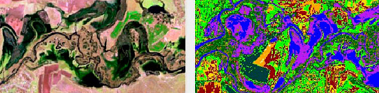
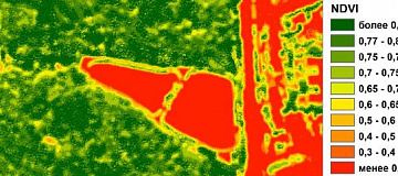
Space image interpretation, creation of training sample polygons for space photo classification: from 1 to 20 days.
Vectorization of the obtained classification: from 1 to 5 days **.
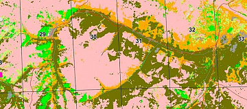
Mapping of the territory with forest damage and degradation: from 1 to 5 days **.
Report writing: from 2 to 15 days.
TOTAL TIME: from 20 days **.

* working days
** from the date of receipt of 100% advance payment, when ordering a new survey the terms will increase

Lead time from 20 days. Depending on the area of forest pathology monitoring, calculated individually for each customer and taking into account the ToR.

How to place an order:

  1. STEP №1: Submit a request for the condition of forests and plantations on the website with the following information:
    • Location of the object under investigation (coordinates, cadastral number, etc.);
    • Frequency of forest pathologic monitoring;
    • Dates for conducting the analysis.
  2. STEP №2: Coordination of the Technical Task and the cost of forest pathologic inspection:
      Technical specialists' work from 70,000 rubles.
    • The images are paid for separately (one image of ultra-high resolution from 300–600 USD).
  3. STEP №3: Contract conclusion and initiation of the execution:
    • Completion period of 20 working days from the date of receiving 100% advance payment - payment is accepted only via non-cash settlement.

We cooperate with individuals, legal entities, individual entrepreneurs, state and municipal authorities, foreign clients, etc.

Need for consultation?

Fill the form and we will contact you

By clicking the «Send» button, you give your consent to the processing of your personal data, in accordance with Federal Law No. 152-FZ of July 27, 2006 «On Personal Data», on the conditions and for the purposes specified in the Consent to the processing of personal data.

Stages of service provision

Stage № 0 (Before Contract Conclusion):

  • Determining the object of observation and examination;
  • Determining the dates and parameters of the desired imaging (period and type);
  • Checking the availability of archival remote sensing data for the area of interest;
  • Verifying the selected archival images that match the client's request;
  • Submitting a request to the operator(s) for new imaging (if necessary).

RESULT: feasibility (YES/NO) of completing the task or objective


Stage № 1 (Before Contract Conclusion):

  • Agreeing with the client on the available remote sensing data or information from operator archives;
  • Agreeing with the buyer, if necessary, on the spacecraft for new imaging, as well as the timing and parameters;
  • Agreeing on the required forest pathologic observation data;
  • Final determination of labor and material costs, agreement on delivery deadlines and costs;
  • Agreeing with the client on the Technical Task for the entire volume.

RESULT: signed contract


Stage № 2 (Contract Execution):

  1. Receiving 100% advance payment;
  2. Ordering materials for space imaging;
  3. Incoming control of remote sensing data;
  4. Processing of remote sensing data, obtaining RCM (Raster Classification Map) if necessary;
  5. Interpreting the satellite image, creating polygons for the classification of the satellite photo;
  6. Vectorization of the obtained classification;
  7. Mapping of the territory with damages and degradation of forest areas;
  8. Preparation of the report.

RESULT: report on the forest pathologic condition, presentation materials, thematic maps of forest degradation.

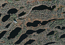
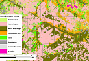
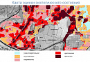
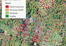
The result of the provision of services

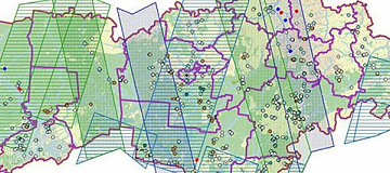
Geo Innother provides a report on the forest pathologic condition, presentation materials, thematic maps of forest degradation, georeferenced Tiff (Geo TIFF), and vector layers of identified objects in Mid/Mif format. All necessary results are delivered on electronic media or through the Internet via FTP servers, and textual materials are also duplicated in printed form.

In addition, based on the research conducted by Geo Innother specialists, it is possible to perform a forensic examination of the forest pathologic condition of the territory.


Requirements for Source Information

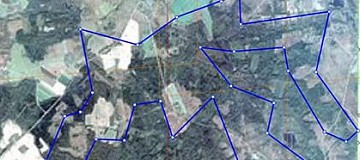
Exact geographical coordinates of the forest examination object in the required coordinate system (Geo Innother specialists will clarify the information provided in any convenient form by the Client).

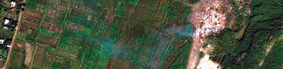
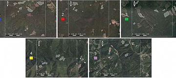
Images that meet the criteria of time of imaging, spatial resolution, and the presence of the necessary spectral channels, with initial georeferencing by RPC (Rational Polynomial Coefficients).

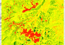
The selection of satellite images for the interpretation of specified images (spatial resolution, mode, spectral range, frequency of space imaging, and other characteristics of satellite images) is carried out based on the tasks of remote observation of the forest pathologic condition.

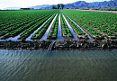
For remote observation of the forest pathologic condition using satellite imagery, photo-spatial resolution from 1 to 30 meters inclusive should be used.

When using multispectral satellite images with spatial resolution from 1 to 3 meters inclusive, changes in the forest pathologic condition must be detected in forest areas of 0.1 hectares and more (The Procedure for Forest Pathologic Monitoring...).

When using multispectral aerial satellite images with spatial resolution from 3 to 10 meters inclusive, changes in the sanitary and forest pathologic condition must be detected in forest areas of 1.0 hectares and more (The Procedure for Forest Pathologic Monitoring...).

If it is not possible to provide the specified information, please provide details on the intended use of remote sensing materials, and Geo Innother specialists will analyze the request and propose the optimal solution to the problem.

Related services

Orthoimagery (Orthorectification)
Find out the price
Remote sensing imagery Interpretation & spectral analysis
Find out the price
Digital agriculture mapping (Crop monitoring)
Find out the price
Digital Topographic Maps
Find out the price
Pollution determination using remote sensing data
Find out the price
Modeling the Territorial Structure Dynamics
Find out the price
Создание ортофотопланов
Find out the price
Создание и обновление цифровых топографических карт
Find out the price
Дешифрирование данных дистанционного зондирования Земли (ДЗЗ)
Find out the price
Выявление локальных источников загрязнений
Find out the price
Изучение структуры и динамики природных территориальных комплексов
Find out the price
Создание цифровых карт сельскохозяйственных угодий
Find out the price
Zazulyak Evgeny Leonidovich
The material was checked by an expert
Zazulyak Evgeny Leonidovich
Engineer, 28 years of experience, Education - Moscow Topographic Polytechnic Technical School, St. Petersburg Higher Military Topographic Command School named after Army General A.I. Antonov, Military Engineering University named after V.V. Kuibyshev. Kuibyshev Military Engineering University.

Customers

Rosneft
Gazprom
Gazprom neft
Lukoil
Transneft

FAQ

The following data set is required for forest condition assessment:
  • Position of the object of interest (coordinates, name of district, region, shp-file, etc.);
  • period requirements (period for which archive data can be used or a new survey is required);
  • whether forest pathology monitoring has been conducted in the area.

The terms of execution of works on forest health monitoring depend on the area, requirements to the survey parameters. The minimum execution period is from 20 working days.
100% prepayment on the invoice for RS materials after signing the contract, the rest of the payment after execution.
For the organization of forest protection measures it is necessary to conduct a survey of the area of forest plantations and sanitary surveys based on the presence of active pest foci a plan to prevent the spread of pests is drawn up. If the forest fund area is owned by the Russian Federation or a state body, the survey and forecast are carried out by executive authorities or local self-government bodies.
According to the Forest Code of the Russian Federation, forests, including forest crops, are subject to protection from pests: viable plants of any species, varieties or biological types, animals, pathogens of any species and biological types that are capable of causing damage to forests and forest resources. Protection of forest crops is aimed at detection of pests and prevention of their spread, and in case of pest and disease outbreaks - their elimination.
The main forest pests to be monitored are: silkworms, star weaver, common pine sawfly, northern, minimizing and big birch sawfly, leafhoppers, elm red-breasted sawfly, mealybugs, sucker cicada and other populations.
To obtain NDVI (vegetation) index, spacecraft, airplanes, UAVs, multirotor drones equipped with NIR cameras are used. The survey is carried out from space or by air carriers from altitudes of 300-700 m, which allows obtaining the most accurate photo. On average, the productivity of this equipment allows to fulfill 5 thousand hectares per day
Yes, quarantine exists to protect forests, and it is carried out by special environmental security bodies. Forest quarantine is a legal regime that provides for a system of state measures aimed at preventing the introduction and/or spread of quarantine pests to protect the country's plant resources Established by the Russian authorities, as well as to ensure official control of pests, established by the executive authority that performs the functions of control and supervision in the field of quarantine and plant protection.
Organization of forest forest health monitoring consists of three stages and includes:
  1. preparatory works (preliminary system of forest health monitoring organization in the region, methods of its conducting are developed);
  2. preliminary forest pathology survey (ground methods can be used);
  3. planning of Forest health monitoring system.
Assessment of forests (assessment of forest plots and assessment of property rights arising from the use of forests) is carried out in accordance with the Federal Law of July 29, 1998 N 135-FZ "On Appraisal Activity in the Russian Federation", is applied by a state or local government body when determining the initial price of a tender for the right to conclude a lease agreement for a state or municipally owned forest plot.
Forest health is worth monitoring for many reasons. Here are just a few, which are the main ones:
  • Forests provide climate stability. In particular, forests have a significant impact on one of the major greenhouse gases;
  • Provide habitat for numerous species of animals and insects;
  • Store water during rainy periods, preventing drought;
  • Protect shores from erosion and soil scouring
LPM is the information basis of the state control over the sanitary condition of forests. Local monitoring - is organized in each lesnichestvo; Regional monitoring - is conducted on the territory of the subjects of the Russian Federation; Federal monitoring - conducted on all forest lands of Russia.
This is the name given to activities conducted in order to obtain information on the current sanitary and forest pathological condition of forest areas, as well as to justify and prescribe forest protection measures. It is carried out by visual, instrumental method, but more often combining one and the other. The ground method is used to accurately determine the boundaries of forest damage. With the visual method, the condition of plantations and individual trees is assessed by eye.
Remote sensing plays a vital role in forest health monitoring by providing valuable data on various aspects of forests. Specific data obtained through remote sensing includes vegetation indices, land surface temperature, tree species identification, and changes in forest cover over time.
Commonly used remote sensing platforms for forest health monitoring include satellites and Unmanned Aerial Vehicles (UAVs). Satellites offer wide-scale coverage and periodic observations, while UAVs provide high spatial resolution and flexibility in capturing detailed information in specific forested areas.
Remote sensing data aids in early detection by capturing spectral signatures associated with stressed vegetation. Changes in vegetation indices and other indicators help identify potential issues such as diseases, pest infestations, or stress factors, enabling timely intervention and forest health management.
Multispectral and hyperspectral imagery contribute to a comprehensive understanding of forest health by capturing a broader range of spectral bands. They provide detailed information on vegetation density, species composition, and biochemical content, allowing for a more nuanced analysis of factors influencing forest health.
Remote sensing supports forest management by providing data for monitoring and assessing forest conditions. Spatial analysis involves processing and interpreting remote sensing data to derive actionable insights, such as identifying areas of deforestation, assessing biodiversity, and guiding conservation strategies to maintain or improve overall forest health.

Licenses

License for implementation of geodetic and cartographic activities (page 1)
License for implementation of geodetic and cartographic activities (page 2)
Application for the license for implementation of geodetic and cartographic activities
ISO 9001:2015 Certificate of Conformity №СДС.ФР.СМ.00813.19 (page 1)
ISO 9001:2015 Certificate of Conformity №СДС.ФР.СМ.00813.19 (page 2)

Warranty

The main regulatory legal documents that determine the tasks and procedures for forest pathologic monitoring are as follows:

  • Article 60.5 of the Forest Code of the Russian Federation - State Forest health monitoring
  • Order of the Ministry of Natural Resources of Russia dated 05.04.2017 No. 156 "On the Approval of the Procedure for State Forest Pathologic Monitoring" (Registered with the Ministry of Justice of Russia on 30.06.2017 No. 47257).
  • Government Decree of 09.12.2020 No. 2047 "On the Approval of Sanitary Safety Rules in Forests".
  • Order of the Ministry of Natural Resources and Environment of the Russian Federation dated 09.11.2020 No. 912 "On the Approval of the Rules for Measures to Prevent the Spread of Harmful Organisms".
  • Order of the Ministry of Natural Resources and Environment of the Russian Federation dated 09.11.2020 No. 910 "On the Approval of the Procedure for Conducting Forest Pathologic Surveys and the Form of the Forest Pathologic Survey Report".

We guarantee 100% quality of service. By cooperating with Geo Innother specialists, you eliminate risks and losses!

The availability of qualified personnel with extensive experience and specialized software allows us to ensure timely and high-quality execution!

Our partners

Request a call back
Back to page top