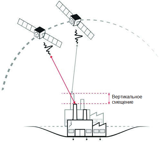
SAR imagery (Radar satellite data) is a special type of space imaging in which microwave radiation with wavelengths ranging from 1 cm to 1 m is used to obtain information by illuminating the Earth's surface and detecting the reflected signals. Radar aerial and space imaging is one of the methods of remote sensing of the Earth's surface, allowing for the acquisition of images of the terrain in the microwave range of the electromagnetic spectrum. Radar images enable the visualization of the Earth's surface and objects regardless of weather conditions, in both day and night time, by emitting and receiving reflected signals from the Earth's surface, followed by the conversion of these signals into images or extraction of phase difference information between the transmitted and reflected signals. The data obtained from radar sensors, similar to optical satellite images, have different spatial resolutions and the ability to capture information in various electromagnetic bands. Radar satellite data consist of two components: the phase component and the amplitude component. The differential interferometric processing of the phase component allows for the measurement of surface displacements, while the processing of the amplitude component enables differentiation of the reflecting surface based on roughness characteristics and volumetric scattering, i.e., object decryption. The technology of differential interferometric processing involves the formation of an interferogram, which, in simplified terms, is the result of multiplying a pair of complex-valued radar images of the same area acquired by identical SAR (Synthetic Aperture Radar) systems from closely located points of the orbit. The phase cycle differences within each pixel in the interferogram represent the relative change in distance between the radar antenna and the reflector (probed surface).

Principle of Differential Interferometry


Applications of SAR imagery/Sar images (Radar satellite data)

SAR imagery/SAR Images (Radar satellite data) is indispensable compared to other observation methods in challenging weather conditions. It offers the ability to obtain images at any time of day and in any weather, precise measurement of coordinates and geometric characteristics of objects, detection of objects invisible in the optical or infrared range of the electromagnetic spectrum, hidden under snow or vegetation cover, or located beneath the Earth's surface.

Работник

Purposes and Objectives of SAR imagery/SAR images (Radar satellite data)

The purpose of space radar imaging is to obtain timely and relevant information about the terrain and water surface, which is necessary for solving numerous tasks in various fields of activity. The main objectives of radar imaging include:

  • Creation and updating of topographic maps and plans, as well as other cartographic products;
  • Creation of engineering-geological maps for geological surveys;
  • Land management and cadastral work;
  • Generation of digital terrain models for planning and development of telecommunication networks;
  • Agricultural research, detection of plant diseases, determination of vegetation phase;
  • Monitoring of emergencies and their consequences, control of emergency restoration work;
  • Forest inventory (forest assessment, determination of age, height, and diameter of growing trees, wood reserves, annual growth, etc.);
  • Detection of oil spills;
  • Detection of fuel dumping from ships;
  • Information support for the prevention and elimination of oil and petroleum product spills;
  • Monitoring of deformation and displacement of the Earth's surface in mining areas;
  • Monitoring of structural deformations in urban areas;
  • Monitoring of critical industrial facilities;
  • Pipeline monitoring;
  • Monitoring of roads and railways and other objects;
  • Monitoring of ice conditions and ship movements;
  • Monitoring of natural and man-made hazardous processes, including earthquakes, landslides, avalanches, sinkholes, flooding, karst, suffusion, river erosion, coastal erosion, and changes in sea and reservoir coastlines.

Initially, the tasks of radar imaging were limited to the study of the ocean surface. However, the scope of radar imaging has expanded, and it now allows for obtaining data on millimeter-level displacements of objects on the Earth's surface, tracking oil pollution and maritime situations in water areas, as well as creating digital terrain models (the well-known SRTM DTM is based on radar data processing).

Advantages of Radar Imaging/SAR Images

Radar imaging offers several advantages compared to other observation methods. It provides high precision in measuring the coordinates and geometric characteristics of objects and the ability to obtain radar images at any time of day and in any weather conditions (microwave radiation easily penetrates through clouds and does not rely on daylight, unlike visible and infrared imagery).

  • Ability to conduct radar imaging in any weather conditions (including strong cloud cover) and at any time of day (including nighttime);
  • High level of detail due to the high spatial resolution of radar imagery;
  • Cost-effective alternative to GPS monitoring of ground displacements.

Innovative processing techniques open up new areas of radar imaging utilization, including:

  • The ability to conduct radar imaging regardless of weather conditions makes it particularly valuable for mapping remote regions in the Far East of Russia and other countries, where snow hinders imaging during the winter and continuous cloud cover occurs during the rainy season throughout the imaging season. Another advantage of radar imaging for cartography is its relatively high spatial resolution, which enables the creation and updating of maps up to a scale of 1:50,000.
  • By using the phase information of radar signals, digital elevation models and terrain models can be created through interferometric processing. These models can be used in various areas of society.
  • Temporal radar images provide information on ground surface displacements. This helps detect ground subsidence in mining areas, deviations of infrastructure objects from their normal positions, and track landslide processes.
  • SAR images of water surfaces enables the detection of oil spills. Due to the specific characteristics of oil, which result in a smoother surface and different reflectivity compared to natural water, oil spills can be easily identified on radar images.
  • SAR images allows for the detection of ships that have intentionally disabled their tracking signals or have lost signal due to accidents. Radar signals are well reflected by metallic surfaces, enabling the automatic detection of ships even on medium-resolution radar images. Moreover, radar images can be obtained just an hour after acquisition, providing more precise information to the relevant authorities.
  • The varying reflectivity of radar imaging allows for the detection of forest fires and deforestation in forest areas, as well as monitoring the condition of agricultural crops.

Prices for services

Consultation Free
Preliminary analysis Free
Radar image order Starting from $1000 per scene depending on the imaging (archive vs. new, resolution) *
Turnaround time From 5 working days (depending on volume, complexity, availability of archive imagery)

The cost of execution is calculated on an individual basis, taking into account a specific of task.

After receiving the task description, we calculate the cost and send you a commercial offer.

Period of execution

Technical task coordination: 1 to 5 days*
Contract signing: 1 to 5 days
Image acquisition: 3 days**
Image processing: 1 to 3 days
TOTAL TIME: 5 days*


business days
** from the date of receiving 100% advance payment

The turnaround time depends on the total area of the survey, the number of processed images, and is calculated individually for each customer.

How to place an order:

STEP 1: Submit an application on the website, providing the following information:

  • Location of the object of interest (coordinates, district name, region, SHP file, etc.);
  • Requirements for the survey period (period for which archival data can be used or the need for a new survey);
  • Requirements for the survey quality.

STEP 2: Technical task coordination and cost agreement:

  • The cost of the work is discussed on a case-by-case basis;
  • Images are paid for separately (starting from $1000 per scene depending on the type of survey - archival or new, mono or stereo, resolution).

STEP 3: Contract signing and commencement of work:

  • The turnaround time is 5 business days from the date of receiving 100% advance payment for the satellite imagery materials - payment is accepted only via bank transfer. The remaining payment is made after the completion of the work.

We work with individuals, legal entities, individual entrepreneurs, government and municipal authorities, foreign customers, etc.

You can also submit your application via email: innoter@innoter.com, or contact us by phone: +7 495 245-0424, or use the online chat on our website.

Need for consultation?

Fill the form and we will contact you

By clicking the «Send» button, you give your consent to the processing of your personal data, in accordance with Federal Law No. 152-FZ of July 27, 2006 «On Personal Data», on the conditions and for the purposes specified in the Consent to the processing of personal data.

Stages of service provision

Stage 0 (Pre-contract stage):

  • Determining the dates and parameters of the desired radar survey (survey period, type of survey)
  • Sending a request to the operator(s) for the execution of the survey

RESULT: Possibility (YES/NO) of providing the service

Stage 1 (Pre-contract stage):

  • Agreeing with the customer on the archival data available from the operators;
  • Agreeing with the customer, if necessary, on the satellite from which the new survey will be conducted, the timeframe, and the survey parameters;
  • Final determination of labor and material costs, agreement on delivery times and costs

RESULT: Signed contract

Stage 2 (Contract execution):

  • Receiving 100% advance payment
  • Ordering satellite imagery materials
  • Incoming quality control of satellite images
  • Preliminary processing of satellite images using specialized software.
  • Preparation of reports and other documents specified in the contract.

The results of the completed work are sent to the customer electronically in agreed-upon formats.

RESULT: The results of the completed work are sent to the customer electronically in agreed-upon formats, according to the Technical Task.

The result of the provision of services

Creation of the final product based on space radar survey materials:

  • Archival radar images
  • Materials from new space radar surveys
  • Materials from space radar interferometric surveys

GEO INNOTER delivers the ready-made products to the customer who requested the space survey materials, according to the Technical Task, on electronic media or via the Internet through FTP servers.

Requirements for source data

Accurate coordinates of the area of interest, requirements for the space survey materials (resolution on the ground, type of survey, survey period).

If it is not possible to provide the specified information, please provide information on the intended use of the remote sensing materials, and GEO INNOTER specialists will analyze the requirements and offer an optimal solution to the problem.

Related services

Digital elevation models (DEM)
Find out the price
Digital terrain models (DTM)
Find out the price
Digital orthoimagery (Orthorectification)
Find out the price
Aerial & UAV imagery
Find out the price
LIDAR Aerial Survey
LIDAR Aerial Survey
Find out the price
Pollution determination using remote sensing data
Find out the price
Создание ортофотопланов
Find out the price
Выявление локальных источников загрязнений
Find out the price
Цифровые модели рельефа (ЦМР)
Find out the price
Цифровые модели местности (ЦММ)
Find out the price
Аэрофотосъемка (АФС / БПЛА)
Find out the price
Лазерное сканирование (LIDAR)
Find out the price
Lavrov Viktor Nikolaevich
The material was checked by an expert
Lavrov Viktor Nikolaevich

Aerophotogeodesist, work experience 58 years, Education - Moscow Institute of Geodesy, Aerial Survey and Cartography (MIIGAiK)

Customers

FAQ

  • Area of interest (location / coordinates of the object in any convenient format, and the area of the object)
  • Date or time interval for which archival imagery can be searched or new imagery can be acquired
  • Requirements for the survey (angle of the image, sun angle, resolution, type of survey, cloud cover)
The terms of work execution depend on the area of the territory, requirements to the survey parameters. The minimum period of work execution is from 5 working days
100% prepayment on the invoice for remote sensing materials after signing the contract, the rest of the payment after the work is done.
SAR imagery/SAR Images (Radar satellite data) is quite an arduous task, because a radar image has a raw image that is unfamiliar to the human eye. Specialized software products are used for radar processing, and specialists should have proper experience in creating secondary products of radar space imagery. However, despite this, the advantages of radar make the use of radar imagery very much in demand.
  • Single Look Complex (SLC) image - information obtained through the focusing of the transmitted signal. The radar image at this processing level includes two channels: an amplitude ("panchromatic") image in grayscale and a phase image of the signal, which is used for creating digital elevation models and displacement maps of the Earth's surface.
  • Geocoded image - The radar image is spatially referenced in a specific coordinate system. Radar images at this processing level are typically delivered in GeoTIFF format.
  • Orthorectified image - High-quality radar image without geometric distortions caused by terrain. Radar satellite imagery at this processing level is used for cartographic materials and spatial analysis.
Synthetic Aperture Radar (SAR) imagery is captured using radar sensors on satellites, providing information on surface characteristics regardless of daylight or weather conditions. Unlike optical imagery, SAR can penetrate clouds and darkness, making it suitable for all-weather and day-and-night applications.
SAR technology contributes to monitoring ground deformation by detecting changes in the phase of radar signals over time. This allows for precise measurements of subsidence or uplift, making SAR suitable for applications such as monitoring land subsidence in urban areas or tracking tectonic movements.
SAR imagery has advantages in agriculture and forestry as it can penetrate vegetation and provide information on crop growth, soil moisture, and forest structure. It supports crop and land monitoring by offering insights into crop health, soil conditions, and changes in vegetation cover, aiding in precision agriculture and forest management.
SAR imagery contributes to disaster management by providing timely and accurate information in the aftermath of disasters. It aids in assessing damage from events such as earthquakes, floods, or landslides, facilitating efficient response efforts, resource allocation, and recovery planning.
Interferometry in SAR, known as InSAR, involves comparing multiple radar images to detect phase differences caused by ground deformation. InSAR enhances precision by enabling the measurement of small changes in elevation. This technique is particularly valuable for monitoring subsidence, uplift, and deformation in various terrains with high accuracy.

Synthetic Aperture Radar (SAR) is a form of radar used to create high-resolution images of landscapes and objects. It works by using the motion of the radar antenna over a target region to simulate a very large antenna or aperture electronically, hence the term "synthetic aperture." SAR is capable of producing detailed images regardless of weather conditions or time of day, making it particularly useful in remote sensing applications. Here’s a detailed explanation of how SAR works and its applications:

How SAR Works

  1. Radar Signal Transmission:

    • A SAR system transmits a radar signal toward the target area from an aircraft or satellite.
  2. Echo Reception:

    • The radar signal bounces off the surface and returns to the radar antenna. The system receives the echoes over a period as it moves along its flight path.
  3. Data Collection:

    • By moving along its path, the radar collects echoes from different points along the surface. This movement effectively simulates a much larger antenna, hence "synthetic aperture."
  4. Signal Processing:

    • Advanced signal processing techniques combine the received echoes to create a high-resolution image. This involves complex algorithms to resolve the phase and amplitude information from the echoes.

Advantages of SAR

  • All-Weather Operation:

    • SAR can penetrate clouds, rain, and other atmospheric conditions, providing reliable imaging regardless of weather.
  • Day and Night Capability:

    • Unlike optical imaging systems, SAR can operate equally well during the day and night.
  • High Resolution:

    • By simulating a large antenna, SAR achieves high-resolution images that are critical for detailed analysis.

Applications of SAR

  1. Earth Observation:

    • Monitoring land use, deforestation, urban sprawl, and agricultural practices.
    • Mapping terrain and generating digital elevation models.
  2. Environmental Monitoring:

    • Tracking changes in ecosystems, wetlands, and coastlines.
    • Detecting oil spills and monitoring ocean currents.
  3. Disaster Management:

    • Assessing damage from natural disasters such as earthquakes, floods, and hurricanes.
    • Providing timely information for rescue and relief operations.
  4. Military and Surveillance:

    • Reconnaissance and surveillance in hostile or inaccessible areas.
    • Detection and tracking of moving targets.
  5. Geological Surveys:

    • Mapping geological features and mineral resources.
    • Monitoring volcanic activity and earthquake-prone regions.
  6. Infrastructure Monitoring:

    • Inspecting bridges, dams, and other critical infrastructure.
    • Monitoring urban development and construction projects.

Conclusion

Synthetic Aperture Radar is a powerful and versatile technology that provides high-resolution imagery under diverse and challenging conditions. Its applications span across various fields including environmental monitoring, disaster management, military surveillance, and geological surveys, making it an invaluable tool for both scientific research and practical applications.

Synthetic Aperture Radar (SAR) imagery is a type of high-resolution image created using radar signals that capture detailed information about the Earth's surface. SAR imagery can penetrate clouds, smoke, and darkness, making it useful for applications such as environmental monitoring, disaster management, and military surveillance.
A radar image is a representation of the Earth's surface or objects on it, created by bouncing radar signals off the target area and capturing the reflected signals. These images provide detailed information about the surface characteristics and can be captured in various weather conditions and during both day and night.
Radar imaging is the process of using radar systems to create images of objects or areas. This technique involves transmitting radar signals, receiving the echoes, and processing these signals to produce images that reveal surface features, textures, and other characteristics. It is widely used in remote sensing, navigation, and military applications.
Synthetic Aperture Radar (SAR) is a form of radar used to produce high-resolution images by utilizing the motion of the radar antenna over the target area. By combining multiple radar signal returns, SAR simulates a large antenna, achieving detailed imaging capabilities regardless of weather conditions or light levels. SAR is extensively used for earth observation, environmental monitoring, and reconnaissance.

Licenses

Warranty

We guarantee 100% quality of service. By collaborating with the specialists of GEO Innoter, you eliminate risks and losses!

Having qualified staff with extensive experience in working with specialized software allows us to guarantee timely and high-quality execution of work!

Advantages of collaborating with GEO Innoter

  • Many years of experience;
  • Direct distribution agreements with satellite imagery operators;
  • Experience in executing projects of any complexity, both with aerial photography and satellite imagery;
  • Availability of modern software for processing remote sensing data;
  • Significant server capacities for processing remote sensing data;
  • A team of highly skilled professionals in the field of cartography and photogrammetry.

Our partners