your companion in the world
of geospatial solutions
Operation mode:
Mon-Fri: 10:00 - 18:00
Sat-Sun: Non-working days

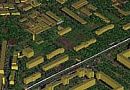
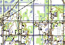
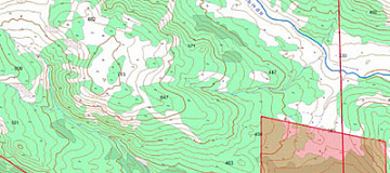
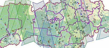
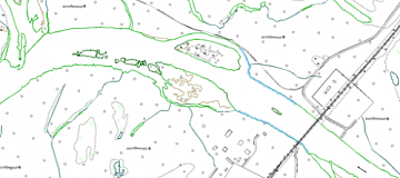
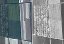
Thematic mapping — a geographical map whose content is defined by a specific theme. Thematic maps represent the distribution of various natural and socio-economic objects and phenomena, characterizing them qualitatively and quantitatively, showing the interrelationships between these objects and phenomena, and their development over time.

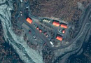
Special maps — are maps used for detailed examination of the terrain, aviation navigation support, transportation organization, and other specialized tasks (the list is regulated by the Resolution of the Government of the Russian Federation dated September 7, 2020, No. 1369).


Purposes of thematic maps

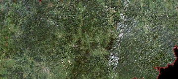
Geological maps - for understanding global, regional, and local characteristics of the Earth's crust structure, ongoing geological processes, exploration of mineral resources, and more.

Geophysical maps - for studying geodynamic phenomena and processes occurring in the Earth's shells and core, and for exploration of mineral deposits.

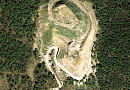
Relief maps - for examining the morphology, genesis, age, and dynamics of land and seafloor relief.

Types of thematic mapping

Climate maps - for analyzing and forecasting the climate of territories and its elements by months, seasons, years, climatic periods, and epochs.

Hydrological maps - for studying the distribution of surface water regime, composition, and properties of terrestrial waters, water balance, and resources of territories.

Oceanographic maps - for studying the world's oceans.

Soil maps - used in soil cadastre accounting, economic assessment of soils, development of agronomic measures and land reclamation, and combating soil erosion.

Zoogeographic maps - for inventory, studying the distribution and migration of animals, their interactions with the environment, and for developing measures for the conservation and reproduction of wildlife.

Socio-economic maps are used in Earth sciences and the development of projects for the development of World Ocean resources, economic assessment of resources, planning measures for their conservation and reproduction, development, and placement of reproduction, extraction of mineral resources on the continental shelf, etc.

Работник

Purposes and Objectives of thematic mapping

The purpose of thematic mapping and special maps is for evaluative research on:

  • Living conditions of the population, the impact of climate on people's health, and adaptability to adverse weather and climatic factors;
  • Agroclimatic conditions and the influence of climate fluctuations on agricultural crop yields;
  • Territory development conditions for civil, industrial, and other types of construction;
  • Recreational conditions of the area, and much more.

The main objective of creating (updating) thematic and special maps is to obtain cartographic products that correspond as closely as possible to the actual state of the area, created in accordance with applicable regulatory and technical documents and the Technical Task.

Maps of exploration and development areas are necessary to solve the following tasks in the oil and gas industry:

  • Identification and study of hazardous geological processes;
  • Determination of karst hazard of the territory;
  • Identification of swamps and marshy areas;
  • Determination of ravine and gully erosion;
  • Identification of potentially hazardous landslide areas.

For safe planning of infrastructure development in oil and gas fields, a complete understanding of the surrounding environment is necessary.

As a result of decoding remote sensing materials, the following aspects are identified:

  • Areas with potential development of landslide processes;
  • Areas with potential development of karst processes;
  • Marshy areas;
  • Ravine and gully network and areas with potential development of ravine and gully processes;
  • Determination of soil types;
  • Determination of types of Quaternary deposits.

In the process of field and laboratory work, the potentially hazardous areas found are verified on-site through soil, rock, and water sampling, chemical analysis, and documentation of field surveys and sampling protocols for quantitative chemical analysis.

The result of decoding remote sensing materials, thematic mapping, sampling, and analysis is the creation of maps of potentially hazardous geological processes. The set of thematic maps should provide information about the natural conditions of the territory where construction will take place and factors of technogenic impact on the environment, evaluation of hazardous processes and phenomena, and the development of measures for environmental protection.

Project Implementation Mechanism:

By using own resources: obtaining and analyzing remote sensing materials, spatial referencing, creating orthophotos, creating digital elevation models (DEM), and creating digital thematic cartographic materials.

Through local partners: fieldwork, chemical and analytical research.

Depending on the customer's requirements, the following thematic maps can be created:

  • Engineering-geological zoning map;
  • Engineering-geological conditions map with a table of characteristics of identified taxons;
  • Map of factual material based on a situational plan;
  • Map of hazardous geological and engineering-geological processes;
  • Map of karst development and karst hazard;
  • Map-scheme of hazardous geological processes development.
The result of the work should provide sufficient materials and data for the project justification of the locations for the placement of territorial and linear facilities, the development of measures and structures for engineering protection, protection of the geological environment, and the creation of safe living conditions for the population, and the development of construction organization projects.

Advantages of Using Remote Sensing Data in Thematic Maps

High and very high-resolution satellite imagery can be obtained more promptly as they may already be in the archives of the operator, and new imagery does not require any coordination with competent authorities.

In addition, aerial imagery allows obtaining images with high spatial resolution (up to 1 cm/pixel) and provides a higher level of detail for orthophotos and models, ensuring the root mean square error (RMSE) of coordinate determination is less than 10 cm. Aerial imagery can also be conducted below continuous cloud cover.

Remote sensing data enable the following:

  • Precise localization of potentially hazardous geological areas;
  • Minimizing fieldwork;
  • Reducing anthropogenic impact on the development territory;
  • Significantly reducing the time required for engineering surveys due to the overview and speed of obtaining remote sensing data.

Prices for services

Consultation Free of charge
Search for images, preliminary analysis of the availability of source data, additional and reference materials Free of charge
Image Ordering From $0.5 to $70 per 1 km2, depending on the type of imagery (archive-new, mono-stereo, resolution)*
Cost of Creating Orthophotomaps From $1 per 1 km2, calculated individually for each specific order, depending on the amount of remote sensing data processed, presence (absence) of ground control points, and the used digital elevation model (DEM).
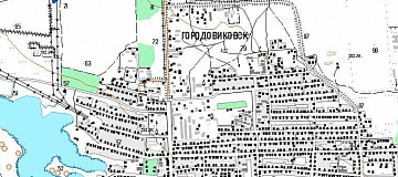
Cost of Creating (Updating) 1 Topographic Map Sheet The cost of creating 1 nomenclature sheet of the map starts from 40,000 rubles and depends on the map scale, complexity category, execution period, and number of nomenclature sheets. The cost of updating depends on the degree of map obsolescence but does not exceed 50% of the creation cost.
Execution Period From 20 working days (depends on the volume, complexity category, availability of remote sensing data, additional and reference materials)

The total cost of creating one nomenclature sheet of the map (from 40,000 rubles) includes the cost of remote sensing data materials used to create the orthophotomap, the cost of the work to produce it, the map's scale, complexity category, and creation period. The cost of updating depends on the degree of obsolescence of the updated map but does not exceed 50% of the creation cost.

The cost of execution is calculated on an individual basis, taking into account a specific of task.

After receiving the task description, we calculate the cost and send you a commercial offer.

Period of execution

Agreement of questions, analysis of the availability of remote sensing data (RS), source map materials, additional and reference data: from 1 to 5*
Contract signing: from 1 to 5*
Obtaining images: from 3 to 10**
Requesting and obtaining source map materials from the State Cartographic and Geodetic Control and Documentation (if necessary): from 1 to 20*
Creation of orthophotomaps (COFP): from 5*
Deciphering and vectorization: from 15*
Summarizing adjacent sheets, performing checks: from 5 to 10*
Report preparation: from 5 to 10
TOTAL TIME: from 20*

* working days
** from the date of receiving 100% advance payment for remote sensing data materials

The timelines for cartographic works depend on the number of nomenclature sheets, scale, and type of the created product, availability of archive remote sensing data, additional and reference materials.

It is essential to understand the purpose of creating the map, know the size, terrain characteristics, and required accuracy of the product to calculate the cost and timelines of the work.

How to place an order:

  1. STEP #1: Leave a request on the website, specifying:
    • Mapping area (coordinates, district, region, shapefile, etc.);
    • Requirements for the map (scale, creation-update, map type);
    • Requirements for remote sensing data (RSD, availability of source map materials, additional and reference data);
    • Work completion deadlines.
  2. STEP #2: Coordination of technical specifications and cost:
    • Purchase of remote sensing data, images are paid separately (from $8 to $70 per 1 km2 depending on the type of imagery, archival-new, mono-stereo, resolution);
    • Coordination of the work execution technology and requirements for the created product.
  3. STEP #3: Contract signing and commencement of work

The starting time for creating orthophotomaps (COFP) for deciphering and vectorization is 5 working days from the date of receiving 100% advance payment for remote sensing data materials. Payment is only accepted via bank transfer. The deciphering and vectorization of objects will begin 3 days after the start of COFP creation.

Need for consultation?

Fill the form and we will contact you

By clicking the «Send» button, you give your consent to the processing of your personal data, in accordance with Federal Law No. 152-FZ of July 27, 2006 «On Personal Data», on the conditions and for the purposes specified in the Consent to the processing of personal data.

Stages of service provision

STEP № 0 (Prior to the conclusion of the contract):

  • Determining the purpose of creating (updating) thematic and special maps;
  • Familiarization with the area of interest;
  • Agreeing on the accuracy characteristics of the product;
  • Preliminary selection and evaluation of archival remote sensing data (DZZ) for compliance with requirements;
  • Planning new imagery if necessary;
  • Determining the availability of cartographic products from the Client, in the federal spatial data fund, for updating or creating a new project.

RESULT: Possibility (YES/NO) of providing the service


STEP № 1 (Prior to the conclusion of the contract):

  • Agreeing with the client on the availability of remote sensing data (DZZ) available in the operator's archives or ordering new imagery;
  • Determining the work technology and confirming with the client the methodology and deadlines;
  • Agreeing with the client on the projection, coordinate system, and height of the created (updated) thematic and special map;
  • Approving with the client the volume of additional data that must be included in the created project;
  • Approving with the client the Technical task for the entire scope of work;
  • Determining the labor costs, costs for remote sensing data materials, additional and reference data, and agreeing on delivery times and the total cost of the work.

RESULT: Signed contract


STEP № 2 (Execution of the contract):

  1. Receiving advance payment (100% prepayment for the purchase of remote sensing data materials);
  2. Ordering remote sensing data materials (conducting new imagery), ordering from available data funds, collecting and analyzing additional and reference materials;
  3. Preparing, agreeing, and approving editorial and technical instructions for the creation (update) of thematic and special maps with the Client;
  4. Incoming control of remote sensing data materials;
  5. Creating digital orthophotoplans necessary for the creation (update) of thematic and special maps;
  6. Deciphering orthophotoplans (thematic processing of remote sensing data), vectorization of terrain objects for creating (updating) thematic and special maps;
  7. Performing visual and automated control of the created product;
  8. Exporting the created (updated) project to the required formats, projection, and coordinate system;
  9. Writing a technical report.

The result of the provision of services

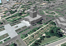
Cartographic products, in formats, projection, coordinate system, and height, according to the Technical Task, consist of remote sensing data (RSD) in the form of digital orthophotoplans and source images, a set of additional and reference materials used in the work, editorial and technical instructions, and a technical report. All results will be delivered on electronic media or via the Internet through FTP servers, with text materials also duplicated in printed form.

Requirements for Source Data

For the qualitative execution of preliminary work, the following must be provided:

  • Coordinates of the cartographic area (in any convenient form)
  • Scale and type of the created (updated) map, format of presentation, how to provide data (per nomenclature sheets or within the cartographic area), projection, coordinate system, and height;
  • Availability of source cartographic materials, additional, and reference data;
  • Lists of coordinates of reference points for photogrammetric processing of remote sensing data;
  • Requirements for the object composition, semantic information of the created (updated) map;
  • The need for the development and coordination of Editorial and Technical Instructions for creating (updating) cartographic products.

If it is not possible to provide the specified information, it is necessary to provide information on the purpose of the maps and the types of work that are planned to be performed using the maps. The specialists of GEO INNOTER will analyze the information and prepare an optimal offer for creating (updating) cartographic products (maps).

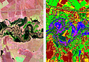
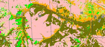
In the process of creating up-to-date thematic maps, existing topographic maps and plans are systematized and used, the completeness and accuracy of which meet the requirements of the created scale, as well as engineering-geological maps, the results of surveys from previous years describing the development of exogenous processes in the survey area, and additional and reference materials (including materials from the CGCF, territorial inspections of the State Geonadzor, and reference-information systems of other agencies).

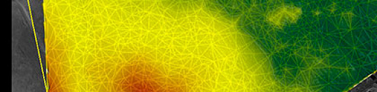
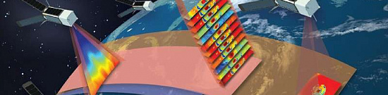
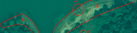
Photogrammetric processing of remote sensing data (DZZ) includes the creation of a plan-altitude basis, creation of a digital elevation model (DEM), obtaining synthesized images, and orthotransformation of images. The construction of a digital elevation model allows identifying a number of geological processes, such as solifluction and landslides, for example.

Deciphering of synthesized orthophotos, "attached" to the digital elevation model, allows not only detailing geological processes but also in some cases more accurately identifying the areas where a particular process occurs.

Related services

Mapping / MAPPING & DATABASE PRODUCTION
Find out the price
Satellite imagery. Satellite data
Find out the price
Orthoimagery (Orthorectification)
Find out the price
Satellite Imagery as evidence in legal proceedings
Find out the price
Satellite & UAV Monitoring
Find out the price
Photogrammetric processing (Image Processing)
Find out the price
Космический мониторинг территории
Find out the price
Судебная экспертиза
Find out the price
Фотограмметрические работы
Find out the price
Заказ космической съемки. Космоснимки
Find out the price
Картографические работы
Find out the price
Создание ортофотопланов
Find out the price

Customers

Роснефть
Газпром
Газпром нефть
Лукойл
Транснефть

FAQ

  • area of interest (location / coordinates of the object in any convenient form, and area of the object);
  • the specific problem to be solved using the digital topographic map
As the main material for creation (update) of thematic and special maps, RS materials available in archives of spacecraft operators for the most current date are used, or new imagery is ordered. In addition, when creating (updating) maps, additional and reference materials are used in the form of various geographical descriptions, maps and atlases of larger (small) scale, reference books, as well as data available to the Customer. The map to be updated can be a map available in the collections of the CGCAP or a map provided by the Customer.
  • The terms of creating a digital topographic map based on space or aerial survey data depend on the volume and complexity of the order. The minimum term - from 5 (five) working days;
  • Delivery time of finished digital topographic maps from 5 (five) working days.
100% prepayment by invoice after signing the contract.
Thematic mapping involves the visualization of specific themes or topics on a map, focusing on conveying information related to a particular subject. Unlike general or topographic mapping, thematic maps are designed to highlight and communicate specific spatial patterns or distributions.
Thematic mapping addresses a wide range of themes, including population distribution, climate patterns, land use, economic indicators, and more. These maps contribute valuable insights in fields such as demographics, environmental science, urban planning, and social sciences by presenting spatial relationships and trends related to specific themes.
Color symbology is employed in thematic mapping to represent different values or categories associated with the chosen theme. Color helps visually distinguish and emphasize variations, making it easier for map readers to interpret and understand the patterns or trends depicted on the map.
Choropleth maps are a common type of thematic map that uses shading or coloring to represent variations in quantitative data across geographic areas. These maps are effective in illustrating spatial patterns of variables such as population density, income levels, or disease prevalence, providing a clear visual representation of data distribution.
Geographic Information System (GIS) technology has revolutionized the creation and analysis of thematic maps. GIS allows for the integration of various data layers, spatial analysis, and dynamic map creation. It enhances the precision and efficiency of thematic mapping, enabling professionals in fields such as public health, environmental science, and urban planning to make informed decisions based on spatial data.

Licenses

License for implementation of geodetic and cartographic activities (page 1)
License for implementation of geodetic and cartographic activities (page 2)
Application for the license for implementation of geodetic and cartographic activities
ISO 9001:2015 Certificate of Conformity №СДС.ФР.СМ.00813.19 (page 1)
ISO 9001:2015 Certificate of Conformity №СДС.ФР.СМ.00813.19 (page 2)

Our partners

Request a call back
Back to page top