



Archival and new images for the observation period, thematic LULC maps and analysis results in the agreed indices and formats.
Search the site
What the service is used for
LULC classification
Extraction of land-use and land-cover characteristics from multispectral satellite and aerial/UAV images: unsupervised and supervised classification, segmentation.
Maps and cadastre
Creation and update of topographic maps and plans, urban and land cadastre, administrative-territorial management.
Agriculture and forestry
Field boundaries, vegetation phases, agricultural land inventory, changes in forestry.
Environment and emergencies
Soil and water pollution, illegal dumps, illegal quarries, forest fires from infrared imagery.
Water resources
Monitoring of changes in water bodies in the area of interest.
Did not find your task?
Describe the territory, period and purpose of monitoring. A specialist will assess the archive and the feasibility of a new survey.
What you will receive as monitoring results
01
Archival images for the monitoring period
Black-and-white, colour, multispectral and synthesised images for the monitoring period according to the ToR.
We select the available archive for the area of interest if the dates and survey parameters are held by the operators.
What you get
- archival images for the agreed period
- a selection by available dates
- materials of the required survey type if available in the archive
- delivery on storage media or via FTP
Availability of frames depends on the operator archive, cloud cover and the actual survey date. There is not an image for every date.
02
New survey materials
New satellite survey of the required type if the archive is insufficient.
We order the survey from the satellite operator after the advance payment and agreement of parameters. A new satellite survey does not require approvals from government authorities.
What you get
- a new survey of the agreed type
- compliance with the contractual time parameters
- incoming quality control of materials
- delivery in the formats specified in the ToR
The new-survey timeline is from 5 working days after prepayment and may increase because of area and climatic conditions.
03
Thematic LULC maps
Land-use and land-cover maps (Land User and Land Cover) according to the agreed classification.
Classification is performed on multispectral satellite and aerial/UAV images: unsupervised, supervised and segmentation.
What you get
- thematic LULC maps
- update of cartographic products based on LULC analysis
- an assessment of the situation on a date and of change dynamics
- materials in the agreed formats
The class composition and legend are set by the terms of reference. The source does not list names of the 12 indices.
04
LULC analysis results
LULC analysis in the agreed indices and formats, including dynamics over the monitoring period.
GEO INNOTER delivers the finished products according to the terms of reference on electronic media or via FTP.
What you get
- analysis results in the agreed indices
- an assessment of changes over a 2–7 year period if the task is set this way
- a report and documents under the contract
- delivery on storage media or via FTP
The exact set of indices and formats depends on the ToR. The source mentions 12 main indices without listing their names.
How the work goes
Cost and timeline
The cost depends on the area, archival or new survey, observation frequency and the scope of thematic processing.
- consultation — free of charge
- preliminary analysis — free of charge
- remote sensing materials per the table — from 0.5 $ per 1 km², calculated individually
- the service card states from 8 $ per 1 km²
- price is affected by area, quality requirements and product type: orthophotomap, DTM, DEM, 3D model, thematic processing
- new survey — from 5 working days after prepayment; timelines may increase for a large area and climatic conditions
- delivery of archival data — from 3 days
- the service card timeline is from 5 days
- the overall timeline in the schedule block is from 15 days
- agreement of requirements — from 1 to 5 working days; contract signing — from 1 to 5 working days
- survey order to the satellite operator — from 5 days from the 100% advance date; thematic processing — from 15 working days
Order cost — from 8 $ per 1 km²
Timeline in the card — from 5 days; overall with processing — from 15 days
Consultation and preliminary analysis — free of charge
What data are needed to quote monitoring
To assess the archive, a new survey and the cost, please provide:
- description of the task for which change monitoring by satellite or aerial/UAV survey is needed
- object location: coordinates, district/region name or a shapefile
- survey frequency requirements
- the period for which the archive can be used, or whether a new survey is required
- quality requirements: off-nadir angles, ground resolution, cloud cover, sun angle, panchromatic, multispectral, hyperspectral or laser survey
- deadlines for delivery of finished materials
- exact coordinates of the area of interest, requirements for remote sensing materials and output data formats
If the exact parameters are unknown, describe the intended use of the remote sensing materials — specialists will analyse the requirements and propose an option.
Describe the task in simple terms — we will assess the archive and the feasibility of a new survey.
Why Innoter
Prompt access to archives
Suitable archive imagery can be obtained faster when the required area and date are already available from operators.
No aviation clearances
A new satellite survey does not require the flight clearances typical of aerial surveys.
Large and remote areas
A single satellite pass covers large areas and makes it possible to work in hard-to-reach regions.
Direct agreements with operators
Distributor agreements help select archival imagery and order new surveys from different suppliers.
Software and server infrastructure
Modern software and computing capacity for quality control and processing of large data volumes.
Experienced specialist team
Many years of experience in complex projects and specialists in cartography, photogrammetry and remote sensing.
Monitoring types, LULC and survey constraints
The composition depends on the task, frequency, archive or new survey, and thematic processing requirements.
1
Baseline — land condition at the start of monitoring. Periodic — data for a month, quarter or year. Operational — land condition at the current moment. For the local level the source recommends monitoring from UAV and drone images.
2
In remote sensing practice, land-use analysis (Land User) and industrial-economic infrastructure / objects (Land Cover) are distinguished, together LULC. The goal is a change-detection system. LULC characteristics are extracted from multispectral images; unsupervised and supervised classification and segmentation are used. For indexing land condition the source mentions 12 main indices, including near-real-time vegetation growth conditions. The element does not list index names.
3
A very-high- and high-resolution archive can be obtained faster: frames may already be held by the operator, and a new satellite survey does not require government approvals. Aircraft or UAV materials are more informative and better in metric properties, but take longer: a flight permit, relocation of the platform and operators are needed, and the cost per 1 km² is several times higher. For change monitoring the source proposes doing this once a year to confirm the satellite survey.
4
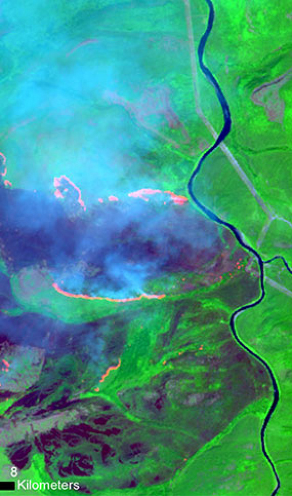
Satellite systems image in the infrared: thermal points — fire seats — are detected from temperature differences, and after processing and georeferencing the fire boundaries are determined. Environmental monitoring: soil and water pollution, negative changes in forestry and agriculture, illegal waste storage sites, unauthorised extraction of natural resources. In agriculture: field boundaries, agricultural land inventory, support of sowing and land reclamation.
5
Agreement of requirements for remote sensing materials — from 1 to 5 working days. Contract signing — from 1 to 5 working days. Survey order to the satellite operator — from 5 days from the 100% advance date. Archival materials — from 3 days from the advance. Thematic processing — from 15 working days. Overall timeline in the schedule block — from 15 days. The service card states from 5 days. New survey in the table — from 5 working days after prepayment, archive — from 3 days. Timelines depend on area, survey parameters and the end product.
6
High- and very-high-resolution images over large territories. Repeated acquisition of characteristics of natural and anthropogenic objects with georeferencing. Operational monitoring without the “human factor” on site. Data for Russia and other countries without restrictions. High survey frequency. Remote sensing methods do not require prior information on land cover or land-use types and do not depend on reporting by people living on the land under study.






Frequently asked questions
Answers to key questions about service parameters, timelines, deliverable formats and workflow. If you did not find what you need — contact us and we will help.
- The task that needs to be addressed using the images;
- Area of interest (location / coordinates of the object in any convenient format, and the area of the object);
- Date or time interval for which archival imagery can be considered or new imagery can be acquired;
- Requirements for the imaging (image tilt angle, solar angle, spatial resolution, imaging type, cloud cover, tolerance for snow cover).
- As a rule, the minimum area for ordering archival satellite images is 25 km2, and for a new satellite survey, it is 100 km2. The minimum strip width (distance between two closest points) depends on the satellite operator, survey mode, and product, and can range from 2 to 5 km.
Land User and Land Cover – «Land use and land cover (soil cover)»
Selected examples:
Selected examples:
- Urban or developed land (Residential / Commercial and other services / Industrial areas / Communications and utilities / Mixed urban or developed land)
- Agricultural land (Arable land and pastures / Gardens, groves, vineyards, nurseries and ornamental garden plots)
- Grassland (Grassland / Shrub and bush pasture / Mixed pasture)
- Forest fund lands (Deciduous forests / Evergreen forest land / Mixed forests)
- Water Resources (Rivers / Streams and Canals / Lakes / Reservoirs / Bays)
- etc.
The study of land cover is part of broad scientific programs of many countries, e.g. UN, NASA, ESA, etc. to monitor the Earth's vital signs from land, air and space, using a multitude of satellites and instruments (sensors), including the International Space Station to better understand our home planet.
Monitoring of changes in the territory of license areas is a comprehensive system of regular observations of the state of land and the environment, collection of information, assessment and forecasting of spatial and temporal changes in the state of environmental components under the influence of natural and anthropogenic factors within the boundaries of the licensed subsoil area during the development, development, operation and liquidation of deposits
- Timely identification of changes in land and environmental conditions within the boundaries of the licensed area.
- Identification of accumulated environmental damage, determination of the extent of its spread, and potential sources of negative impact.
- Evaluation of the dynamics of environmental changes within the boundaries of the licensed areas.
- Assessment of changes in land conditions, forecasting, and development of recommendations for preventing and mitigating the consequences of negative processes.
- Organization of data collection, transmission, processing, systematization, and storage of information on land and environmental conditions.
- Monitoring changes in the condition of industrial facilities, intra-field pipelines, exploration wells, and other infrastructure objects whose location is lost; identification of objects in non-design positions.
- Control over compliance with land use conditions - correlating the actual boundaries of industrial facilities with the boundaries stipulated in land allocation acts, and identifying unregistered objects for inventory and cadastral registration of real estate.
- Monitoring the condition of slurry barns, monitoring the pace of slurry barn reclamation, and the condition of slurry reservoirs and slurry processing plants.
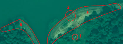
- Monitoring the integrity of spoil heaps, embankments, hydraulic structures, and roads within licensed areas.
- Inventory of flare systems for associated petroleum gas combustion, monitoring the volume of gas burned.
- Inventory of common mineral extraction sites, the condition of their extraction areas to ensure industrial and environmental safety.
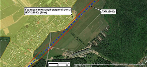
- Identification and control of additional industrial activities at the field - power line installation, selective and clear-cut logging, monitoring the condition of access roads, subcontractor activities.
- Monitoring the environment within licensed areas (deforestation, oil spills, etc.).
regular acquisition and interpretation of information on the state of the Earth's surface from remote sensing spacecraft
Earth remote sensing from space makes it possible to obtain data on hard-to-reach objects and to observe large areas, including without local authority clearances
Need satellite imagery or help choosing the right data?
Describe your task, area of interest, and desired outcome. We will check data
availability, assess new acquisition options, and propose the optimal solution in terms of timelines, cost,
and quality.
Discuss the project
clients who trust us
25+ years in the geodata market






